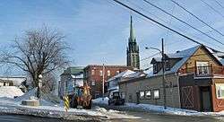
East Angus, Quebec
| East Angus | |
|---|---|
| City | |
 | |
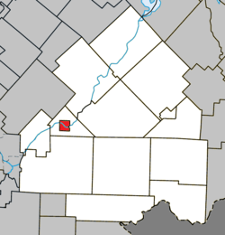 Location within Le Haut-Saint-François RCM | |
 East Angus Location in southern Quebec | |
| Coordinates: 45°29′N 71°40′W / 45.483°N 71.667°WCoordinates: 45°29′N 71°40′W / 45.483°N 71.667°W[1] | |
| Country |
|
| Province |
|
| Region | Estrie |
| RCM | Le Haut-Saint-François |
| Constituted | March 14, 1912 |
| Government[2] | |
| • Mayor | Robert G. Roy |
| • Federal riding | Compton—Stanstead |
| • Prov. riding | Mégantic |
| Area[2][3] | |
| • Total | 8.30 km2 (3.20 sq mi) |
| • Land | 7.91 km2 (3.05 sq mi) |
| Population (2011)[3] | |
| • Total | 3,741 |
| • Density | 472.7/km2 (1,224/sq mi) |
| • Pop 2006-2011 |
|
| Time zone | UTC−5 (EST) |
| • Summer (DST) | UTC−4 (EDT) |
| Postal code(s) | J0B 1R0 |
| Area code(s) | 819 |
| Highways |
|
| Website |
www |
East Angus is a city in Le Haut-Saint-François Regional County Municipality, in Quebec, Canada. The city had a population of 3,741 as of the Canada 2011 Census.
References
External links

| Cities & Towns | |
|---|---|
| Municipalities | |
| Townships | |
| |
This article is issued from
Wikipedia.
The text is licensed under Creative Commons - Attribution - Sharealike.
Additional terms may apply for the media files.