Hampden, Quebec
| Hampden | |
|---|---|
| Township municipality | |
 | |
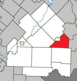 Location within Le Haut-Saint-François RCM | |
 Hampden Location in southern Quebec | |
| Coordinates: 45°30′N 71°15′W / 45.5°N 71.25°WCoordinates: 45°30′N 71°15′W / 45.5°N 71.25°W[1] | |
| Country |
|
| Province |
|
| Region | Estrie |
| RCM | Le Haut-Saint-François |
| Constituted | January 1, 1874 |
| Government[2] | |
| • Mayor | Bertrand Prévost |
| • Federal riding | Compton—Stanstead |
| • Prov. riding | Mégantic |
| Area[2][3] | |
| • Total | 111.80 km2 (43.17 sq mi) |
| • Land | 112.70 km2 (43.51 sq mi) |
|
There is an apparent contradiction between two authoritative sources | |
| Population (2011)[3] | |
| • Total | 214 |
| • Density | 1.9/km2 (5/sq mi) |
| • Pop 2006-2011 |
|
| Time zone | UTC−5 (EST) |
| • Summer (DST) | UTC−4 (EDT) |
| Postal code(s) | J0B 1Y0 |
| Area code(s) | 819 |
| Highways |
|
| Website |
www |
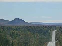
Hampden is a township municipality of about 200 people in Le Haut-Saint-François Regional County Municipality, in the Estrie region of Quebec, Canada.
References
External links

Places adjacent to Hampden, Quebec | |
|---|---|
| Cities & Towns | |
|---|---|
| Municipalities | |
| Townships | |
| |
This article is issued from
Wikipedia.
The text is licensed under Creative Commons - Attribution - Sharealike.
Additional terms may apply for the media files.