Newport, Quebec
| Newport | |
|---|---|
| Municipality | |
 | |
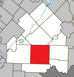 Location within Le Haut-Saint-François RCM | |
 Newport Location in southern Quebec | |
| Coordinates: 45°23′N 71°29′W / 45.383°N 71.483°WCoordinates: 45°23′N 71°29′W / 45.383°N 71.483°W[1] | |
| Country |
|
| Province |
|
| Region | Estrie |
| RCM | Le Haut-Saint-François |
| Constituted | January 1, 2006 |
| Government[2] | |
| • Mayor | Thérèse Ménard-Théroux |
| • Federal riding | Compton—Stanstead |
| • Prov. riding | Mégantic |
| Area[2][3] | |
| • Total | 272.50 km2 (105.21 sq mi) |
| • Land | 271.88 km2 (104.97 sq mi) |
| Population (2011)[3] | |
| • Total | 720 |
| • Density | 2.6/km2 (7/sq mi) |
| • Pop 2006-2011 |
|
| Time zone | UTC−5 (EST) |
| • Summer (DST) | UTC−4 (EDT) |
| Postal code(s) | J0B 1M0 |
| Area code(s) | 819 |
| Highways |
|
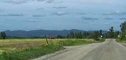
Newport is a municipality of about 700 people in Le Haut-Saint-François Regional County Municipality, in Quebec, Canada. Newport has a small town called Island Brook.
On July 24, 2002, the then-township of Newport was amalgamated into the city of Cookshire-Eaton as part of the early 2000s municipal reorganization in Quebec. After a referendum, Newport de-merged and became an independent municipality on January 1, 2006. However, it remains part of the urban agglomeration of Cookshire-Eaton.
References
External links

Places adjacent to Newport, Quebec | |
|---|---|
| Cities & Towns | |
|---|---|
| Municipalities | |
| Townships | |
| |
This article is issued from
Wikipedia.
The text is licensed under Creative Commons - Attribution - Sharealike.
Additional terms may apply for the media files.