Saint-Isidore-de-Clifton, Quebec
| Saint-Isidore-de-Clifton | |
|---|---|
| Municipality | |
 | |
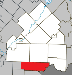 Location within Le Haut-Saint-François RCM | |
 St-Isidore-de-Clifton Location in southern Quebec | |
| Coordinates: 45°16′N 71°31′W / 45.27°N 71.52°WCoordinates: 45°16′N 71°31′W / 45.27°N 71.52°W[1] | |
| Country |
|
| Province |
|
| Region | Estrie |
| RCM | Le Haut-Saint-François |
| Constituted | December 24, 1997 |
| Government[2] | |
| • Mayor | André Perron |
| • Federal riding | Compton—Stanstead |
| • Prov. riding | Mégantic |
| Area[2][3] | |
| • Total | 178.60 km2 (68.96 sq mi) |
| • Land | 177.23 km2 (68.43 sq mi) |
| Population (2011)[3] | |
| • Total | 716 |
| • Density | 4.0/km2 (10/sq mi) |
| • Pop 2006-2011 |
|
| Time zone | UTC−5 (EST) |
| • Summer (DST) | UTC−4 (EDT) |
| Postal code(s) | J0B 2X0 |
| Area code(s) | 819 |
| Highways |
|
| Website |
www |
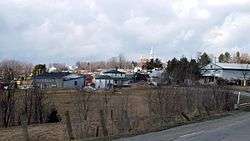
Saint-Isidore-de-Clifton is a municipality of 800 people in Le Haut-Saint-François Regional County Municipality, in Quebec, Canada on the Canada–United States border.
References
External links

Places adjacent to Saint-Isidore-de-Clifton, Quebec | ||||||||||
|---|---|---|---|---|---|---|---|---|---|---|
| ||||||||||
| Cities & Towns | |
|---|---|
| Municipalities | |
| Townships | |
| |
This article is issued from
Wikipedia.
The text is licensed under Creative Commons - Attribution - Sharealike.
Additional terms may apply for the media files.