Wastedo, Minnesota
| Wastedo, Minnesota | |
|---|---|
| Unincorporated community | |
 Wastedo  Wastedo | |
| Coordinates: 44°24′17″N 92°51′05″W / 44.40472°N 92.85139°WCoordinates: 44°24′17″N 92°51′05″W / 44.40472°N 92.85139°W | |
| Country | United States |
| State | Minnesota |
| County | Goodhue |
| Township | Leon |
| Elevation | 1,188 ft (362 m) |
| Time zone | UTC-6 (Central (CST)) |
| • Summer (DST) | UTC-5 (CDT) |
| ZIP code | 55009 |
| Area code(s) | 507 |
| GNIS feature ID | 654996[1] |
Wastedo is an unincorporated community in Leon Township, Goodhue County, Minnesota, United States.
The community is located at the junction of U.S. Highway 52, 380th Street (County Road 9), and 90th Avenue.
Nearby places include Cannon Falls, Hader, and Zumbrota.
Wastedo was settled in 1856. The community had a post office from 1857 until 1903.[2]
References
- ↑ "Wastedo, Minnesota". Geographic Names Information System. United States Geological Survey.
- ↑ "Goodhue County". Jim Forte Postal History. Retrieved 4 October 2014.
Municipalities and communities of Goodhue County, Minnesota, United States | ||
|---|---|---|
| Cities | 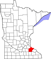 | |
| Townships | ||
| CDP | ||
| Unincorporated communities | ||
| Indian reservation | ||
| Ghost towns/Neighborhoods | ||
| Footnotes | ‡This populated place also has portions in an adjacent county or counties | |
This article is issued from
Wikipedia.
The text is licensed under Creative Commons - Attribution - Sharealike.
Additional terms may apply for the media files.