Hay Creek, Minnesota
| Hay Creek, Minnesota | |
|---|---|
| Unincorporated community | |
 Hay Creek  Hay Creek | |
| Coordinates: 44°29′31″N 92°32′38″W / 44.49194°N 92.54389°WCoordinates: 44°29′31″N 92°32′38″W / 44.49194°N 92.54389°W | |
| Country | United States |
| State | Minnesota |
| County | Goodhue |
| Township | Hay Creek |
| Elevation | 833 ft (254 m) |
| Time zone | UTC-6 (Central (CST)) |
| • Summer (DST) | UTC-5 (CDT) |
| ZIP code | 55066 |
| Area code(s) | 651 |
| GNIS feature ID | 644751[1] |
Hay Creek is an unincorporated community in Hay Creek Township, Goodhue County, Minnesota, United States.
The community is located at the junction of State Highway 58 (MN 58), Hay Creek Trail, and 315th Street.
Hay Creek flows through the community. Nearby places include Red Wing, Goodhue, Belvidere Mills, Frontenac, and Lake City.
Hay Creek was once a station on the Chicago Great Western Railway between Red Wing and Rochester, Minnesota.[2][3] The abandoned railroad right-of-way is being developed as the Goodhue Pioneer State Trail.
References
- ↑ "Hay Creek, Minnesota". Geographic Names Information System. United States Geological Survey.
- ↑ Chicago and Great Western timetable, Randolph and Osage, Traveler's Railway Guide, Western Section (March 1903), p. 74
- ↑ Photograph of Hay Creek depot, Goodhue County Historical Society (1916)
Municipalities and communities of Goodhue County, Minnesota, United States | ||
|---|---|---|
| Cities | 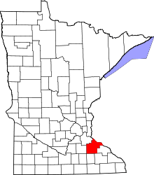 | |
| Townships | ||
| CDP | ||
| Unincorporated communities | ||
| Indian reservation | ||
| Ghost towns/Neighborhoods | ||
| Footnotes | ‡This populated place also has portions in an adjacent county or counties | |
This article is issued from
Wikipedia.
The text is licensed under Creative Commons - Attribution - Sharealike.
Additional terms may apply for the media files.