Hader, Minnesota
| Hader, Minnesota | |
|---|---|
| Unincorporated community | |
 Hader  Hader | |
| Coordinates: 44°21′56″N 92°48′04″W / 44.36556°N 92.80111°WCoordinates: 44°21′56″N 92°48′04″W / 44.36556°N 92.80111°W | |
| Country | United States |
| State | Minnesota |
| County | Goodhue |
| Townships | Leon, Wanamingo |
| Elevation | 1,181 ft (360 m) |
| Time zone | UTC-6 (Central (CST)) |
| • Summer (DST) | UTC-5 (CDT) |
| ZIP code | 55992 |
| Area code(s) | 507 |
| GNIS feature ID | 654739[1] |
Hader is an unincorporated community in Goodhue County, Minnesota, United States.
The community is located at the junction of U.S. Highway 52, State Highway 57 (MN 57), and Goodhue County Road 8 (County 8 Boulevard).
Hader is located within Leon Township and Wanamingo Township. Nearby places include Zumbrota, Wanamingo, Goodhue, Minneola Township, Belle Creek Township, and Cannon Falls.
ZIP codes 55992 (Zumbrota), 55983 (Wanamingo), 55009 (Cannon Falls), and 55027 (Goodhue) all meet near Hader.
History
When Hader was founded by Otis F. Smith in 1857, it was built in order to be the county seat. However, these plans failed, the plat was not fulfilled, and few buildings were built during that time.
References
Municipalities and communities of Goodhue County, Minnesota, United States | ||
|---|---|---|
| Cities | 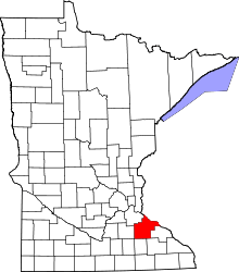 | |
| Townships | ||
| CDP | ||
| Unincorporated communities | ||
| Indian reservation | ||
| Ghost towns/Neighborhoods | ||
| Footnotes | ‡This populated place also has portions in an adjacent county or counties | |
This article is issued from
Wikipedia.
The text is licensed under Creative Commons - Attribution - Sharealike.
Additional terms may apply for the media files.