Claybank, Minnesota
| Claybank, Minnesota | |
|---|---|
| Unincorporated community | |
 Claybank  Claybank | |
| Coordinates: 44°26′30″N 92°37′55″W / 44.44167°N 92.63194°WCoordinates: 44°26′30″N 92°37′55″W / 44.44167°N 92.63194°W | |
| Country | United States |
| State | Minnesota |
| County | Goodhue |
| Township | Goodhue |
| Elevation | 1,060 ft (320 m) |
| Time zone | UTC-6 (Central (CST)) |
| • Summer (DST) | UTC-5 (CDT) |
| ZIP code | 55027 |
| Area code(s) | 651 |
| GNIS feature ID | 654645[1] |
Claybank is an unincorporated community in Goodhue Township, Goodhue County, Minnesota, United States.
The community is located near the junction of County 6 Boulevard and 350th Street. State Highway 58 (MN 58) is nearby. Nearby communities include Goodhue, Ryan, White Rock, Vasa, Belvidere Mills, and Hay Creek.
It was once a station on the former Chicago Great Western Railway between Red Wing and Rochester, Minnesota.[2] Rail spurs extended two miles to the east to clay pits, where clay was mined and shipped by rail to the stoneware industry of Red Wing.[3][4] A post office was established as Claybank in 1890, and remained in operation until 1904.[5]
References
- ↑ "Claybank, Minnesota". Geographic Names Information System. United States Geological Survey.
- ↑ Chicago and Great Western timetable, Randolph and Osage, Traveler's Railway Guide, Western Section (March 1903), p. 74
- ↑ 1894 Partial plat of Goodhue Township showing Claybank and locations of clay mining properties
- ↑ Upham, Warren (1920). Minnesota Geographic Names: Their Origin and Historic Significance. Minnesota Historical Society. p. 206.
- ↑ "Goodhue County". Jim Forte Postal History. Retrieved 14 June 2015.
Municipalities and communities of Goodhue County, Minnesota, United States | ||
|---|---|---|
| Cities | 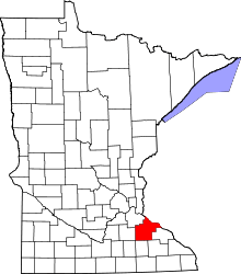 | |
| Townships | ||
| CDP | ||
| Unincorporated communities | ||
| Indian reservation | ||
| Ghost towns/Neighborhoods | ||
| Footnotes | ‡This populated place also has portions in an adjacent county or counties | |
This article is issued from
Wikipedia.
The text is licensed under Creative Commons - Attribution - Sharealike.
Additional terms may apply for the media files.