Wacouta, Minnesota
| Wacouta, Minnesota | |
|---|---|
| Unincorporated community | |
 Wacouta  Wacouta | |
| Coordinates: 44°32′42″N 92°26′06″W / 44.54500°N 92.43500°WCoordinates: 44°32′42″N 92°26′06″W / 44.54500°N 92.43500°W | |
| Country | United States |
| State | Minnesota |
| County | Goodhue |
| Township | Wacouta |
| Elevation | 715 ft (218 m) |
| Time zone | UTC-6 (Central (CST)) |
| • Summer (DST) | UTC-5 (CDT) |
| ZIP code | 55066 |
| Area code(s) | 651 |
| GNIS feature ID | 653706[1] |
Wacouta is an unincorporated community in Wacouta Township, Goodhue County, Minnesota, United States.
The community is located southeast of Red Wing along Highways 61 and 63. Bullard Creek flows through the community, with the Mississippi River and Lake Pepin located nearby.
Nearby places include Red Wing, Frontenac, Hay Creek, and Lake City.
References
Municipalities and communities of Goodhue County, Minnesota, United States | ||
|---|---|---|
| Cities | 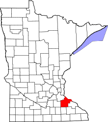 | |
| Townships | ||
| CDP | ||
| Unincorporated communities | ||
| Indian reservation | ||
| Ghost towns/Neighborhoods | ||
| Footnotes | ‡This populated place also has portions in an adjacent county or counties | |
This article is issued from
Wikipedia.
The text is licensed under Creative Commons - Attribution - Sharealike.
Additional terms may apply for the media files.