Washington State Route 99
| ||||
|---|---|---|---|---|
|
Pacific Highway William P. Stewart Memorial Highway | ||||
|
A map of the Seattle metropolitan area with SR 99 highlighted in red. | ||||
| Route information | ||||
| Defined by RCW 47.17.160 | ||||
| Maintained by WSDOT | ||||
| Length | 49.13 mi[1] (79.07 km) | |||
| Existed | 1969–present | |||
| Southern segment | ||||
| South end |
| |||
| Major junctions |
| |||
| North end |
| |||
| Northern segment | ||||
| South end |
| |||
| Major junctions |
| |||
| North end |
| |||
| Location | ||||
| Counties | Pierce, King, Snohomish | |||
| Highway system | ||||
| ||||

State Route 99 (SR 99), also known as the Pacific Highway, is a state highway in the Seattle metropolitan area, part of the U.S. state of Washington. It runs 49 miles (79 km) from Fife in the south to Everett in the north, passing through the cities of Federal Way, SeaTac, Seattle, Shoreline, and Lynnwood. The highway is divided into two segments by a 2-mile (3.2 km) gap in the city of Tukwila, between the interchanges of SR 518 and SR 599. The route primarily follows arterial streets and has several freeway segments, including the Alaskan Way Viaduct in Downtown Seattle.
SR 99 follows a section of U.S. Route 99 (US 99), which originally crossed the state from south to north. US 99 was created in 1926 and replaced earlier local roads that date back to the 1890s and state roads designated as early as 1913. The highway was moved onto the Alaskan Way Viaduct in 1953, replacing a congested stretch through Downtown Seattle, and other sections were built to expressway standards in the 1950s.
US 99 was ultimately replaced by the Tacoma–Everett section of Interstate 5 (I-5), which opened in stages between 1965 and 1969. The route was de-certified in 1969 and SR 99 was created to keep segments of the highway under state control. It was officially named the William P. Stewart Memorial Highway in 2016, after a 15-year campaign to replace an earlier designation honoring Confederate president Jefferson Davis.
Route description
SR 99 follows a section of former U.S. Route 99 (US 99) within the Seattle metropolitan area, from Fife to southern Everett.[2] It is officially designated as the William P. Stewart Memorial Highway, but is commonly known as the Pacific Highway or by one of its local monikers.[2] The entire highway is listed as part of the National Highway System, a national network of roads identified as important to the national economy, defense, and mobility.[3][4] A section of the highway from Tukwila to Shoreline is also designated as a Highway of Statewide Significance by the state legislature.[5] The Washington State Department of Transportation (WSDOT) estimates that average traffic volumes on SR 99, measured in terms of average annual daily traffic for 2016, range from a minimum of 17,000 vehicles on Everett Mall Way to a maximum of 97,000 at the First Avenue South Bridge in Seattle.[6]
Fife to SeaTac
SR 99 begins in Fife as an extension of 54th Avenue East at a partial cloverleaf interchange with Interstate 5. Immediately north of the interchange, SR 99 turns east onto Pacific Highway and passes the Emerald Queen Casino, a gambling and hotel facility operated by the Puyallup Tribe, and a commercial district at the outskirts of Fife. The highway makes a gradual turn to the north, parallel to Interstate 5 and the West Fork of Hylebos Creek, and enters Milton. SR 99 travels north along a ridge and crosses into King County, turning northeast and entering the city of Federal Way in King County. The road cuts through a forested part of the Hylebos basin near West Hylebos Wetlands Park and reaches a commercial district surrounding Kitts Corner.[7][8]
At Kitts Corner, the highway intersects the western section of State Route 18, which continues east to an interchange with I-5 and onto a freeway traveling towards Auburn and Covington.[9] SR 99 continues due north through Federal Way's main commercial strip and passing Celebration Park, The Commons at Federal Way, and Steel Lake. The highway gains a set of high-occupancy vehicle lanes that are also open to right turns into parking lots and side streets.[1] From northern Federal Way to the Redondo area of Des Moines, SR 99 is concurrent with SR 509, which continues southwest to Dash Point State Park and northwest to downtown Des Moines, for four miles (6 km).[8][9]
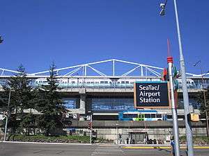
The two highways pass Saltwater State Park and the former Midway landfill before splitting near Highline College at an intersection with Kent Des Moines Road (SR 516). SR 99 then enters the city of SeaTac and continues north as International Boulevard, passing a federal detention center and light rail station on the southwest side of Angle Lake. The highway runs along the east side of Seattle–Tacoma International Airport and its expressway, serving the airport's terminals, parking garage, light rail station, and nearby hotels. SR 99 terminates at an interchange with State Route 518 in southern Tukwila, near the airport's consolidated rental car facility and the Tukwila light rail station.[8][9] A 2.4-mile (3.9 km) segment of International Boulevard forms the gap between the two segments of SR 99.[10]
Seattle and Aurora Avenue
SR 99 resumes at the north end of Tukwila International Boulevard and supersedes SR 599, a short freeway connecting to I-5, near the Duwamish River. The freeway travels northwest along the river's west bank through an industrial area that faces Boeing Field. It then enters the city of Seattle and intersects the Des Moines Memorial Drive in the South Park neighborhood before the freeway ends. At an interchange with SR 509, SR 99 turns north and travels across the Duwamish River on the First Avenue South Bridge, a pair of bascule bridges that form a continuation of the SR 509 freeway.[11][12]
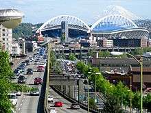
At the north end of the bridge, SR 99 turns northwest onto East Marginal Way South and travels through Seattle's industrial neighborhood along the east bank of the Duwamish Waterway. The six-lane street turns north and passes a cement factory before transforming into a four-lane freeway at an interchange with the West Seattle Freeway on the east end of the West Seattle Bridge. SR 99 widens to six lanes, including a northbound bus lane, and passes through the SoDo neighborhood as the dividing line between the Port of Seattle's container ship terminals to the west and industrial businesses to the east beyond a rail terminal. The freeway passes the corporate headquarters of Starbucks and Coast Guard Station Seattle before turning northeast and reaching the future portal of the Alaskan Way Tunnel near CenturyLink Field and Safeco Field. SR 99 then ascends a set of temporary ramps to join the Alaskan Way Viaduct,[13] a double-decker freeway that runs along the city's waterfront.[9][11]
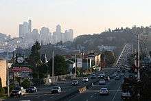
The Alaskan Way Viaduct continues northwest along the central waterfront, flanked to the west by the surface Alaskan Way. The viaduct has a single set of ramps to Downtown Seattle on Seneca and Columbia streets and passes the city's ferry terminal, Seattle Aquarium, and Pike Place Market. Near Victor Steinbrueck Park, SR 99 begins its descent from the viaduct and intersects Elliott and Western avenues before traveling into the Battery Street Tunnel, which runs northeasterly under Battery Street for 3,140 feet (960 m) through Belltown.[14] SR 99 emerges from the tunnel at Denny Way and travels north onto Aurora Avenue North through the South Lake Union neighborhood, located to the east of the Seattle Center and iconic Space Needle. Between crossings of Harrison and Mercer streets, the highway passes the north portal of the Alaskan Way Tunnel, which is planned to replace the viaduct and Battery Street Tunnel when it opens to traffic in February 2018.[15] Aurora Avenue continues north as a six-lane street with bus lanes and a median barrier that restricts access from side streets to right-in/right-out. The highway runs along the eastern slope of Queen Anne Hill, above the Westlake neighborhood along Lake Union, to the Lake Washington Ship Canal.[9][11]
Aurora Avenue then crosses the ship canal on the George Washington Memorial Bridge (commonly known as the Aurora Bridge), a steel cantilever arch bridge with a clearance of 167 feet (51 m).[16] The bridge has six lanes and no median barrier, which resumes after an interchange with Bridge Way on the north approach, which crosses over the Fremont Troll.[17] The highway continues north through part of Fremont and intersects North 46th Street before entering Woodland Park. SR 99 forms the boundary between Woodland Park to the east and the Woodland Park Zoo to the west and passes under a series of three pedestrian overpasses.[18] The highway turns northeast to follow the shore of Green Lake and passes through the residential districts of Phinney Ridge and Greenwood, where traffic signals replace the medians and right-in/right-out access. SR 99 passes west of the North Seattle College campus in Licton Springs and intersects Northgate Way, a major street that provides access to Northgate Mall. Aurora Avenue then bisects the Evergreen Washelli Memorial Park, the city's largest cemetery,[19] and passes between Haller Lake and Bitter Lake before reaching the northern city limit at North 145th Street (SR 523).[9][11]
Shoreline and Snohomish County
SR 99 enters Shoreline and passes through the city's main commercial district, running parallel to the Interurban Trail.[20] The stretch of Aurora Avenue through Shoreline has a landscaped median, plant buffers for sidewalks, several left-turn pockets, and an overpass for the Interurban Trail.[21] Near Shorewood High School and the Shoreline city hall, the highway is flanked to the east by the Interurban Trail and a park with a preserved section of the original North Trunk Road, which was paved in red bricks.[22] After passing Echo Lake and the Aurora Village shopping center, SR 99 reaches the boundary between King and Snohomish counties and a partial cloverleaf interchange with SR 104 and its spur route on the county line itself.[11]
_northbound_at_4th_Avenue%2C_Everett.jpg)
After the interchange, the highway turns northeast and runs through a predominantly commercial area of Edmonds, passing east of the Swedish Medical Center's Edmonds campus and west of Hall Creek and the Interurban Trail. SR 99 continues northeast into Lynnwood and passes the Edmonds Community College campus before reaching the Crossroads commercial district at a junction with 196th Street Southwest (SR 524).[23] The highway runs along the city's retail strip and through its international district (also described as a Koreatown),[24] which is surrounded by apartments and homes that are setback from SR 99. After leaving Lynnwood city limits and entering an unincorporated area south of Paine Field, SR 99 passes Lake Serene and intersects SR 525 at a partial cloverleaf interchange.[11]
The highway travels north into Everett on Evergreen Way and turns northeast onto Everett Mall Way in the Fairmont neighborhood. SR 99 then passes through several residential subdivisions and reaches the Everett Mall, where it turns north and terminates at the Broadway Interchange. The interchange includes connections to I-5, the Boeing Freeway (SR 526), and SR 527. The road itself continues north towards Downtown Everett as Broadway.[11]
History
Pacific Highway and U.S. Route 99
SR 99 was created from the remnants of U.S. Route 99 (US 99), a highway which spanned Western Washington from the Oregon border in Vancouver to the Canadian border at the Peace Arch in Blaine. US 99 itself was preceded by a century-old network of military roads, wagon roads, and auto trails that were built across the state in the 19th century and early 20th century until it was formally incorporated into the state highway system.[25]
In southern King County, modern-day SR 99 follows a section of the Fort Steilacoom–Fort Bellingham military road, constructed in the 1850s by the U.S. Army.[26] A section north of Seattle follows the R.F. Morrow wagon road, constructed in 1901 and later incorporated into the North Trunk Road.[27] The North Trunk Road was completed from Seattle to the area east of Edmonds in August 1912 and initially paved with bricks.[28] An interurban railway was also built along sections of the wagon road in 1906 and would serve Everett–Seattle traffic until 1939.[29]
The Pacific Highway, an inter-state coastal highway, was championed by good roads advocates in the early 1910s and added to the state highway system in 1913.[30][31] It originally followed the White River valley from Tacoma to Renton and the Bothell–Everett Highway along North Creek in Snohomish County.[31][32] The highway was designated as State Road 1 in 1923,[33] a number that it would retain after the creation of Primary State Highway 1 (PSH 1) in 1937.[34] The Pacific Highway was incorporated into the new national numbered highway system in 1926 as US 99, connecting the three West Coast states and running from the Mexican border to Canada.[35] The Bothell route was bypassed by a newer and straighter highway to the west that opened on October 9, 1927.[36] It was built by the state government in tandem with a set of new bridges connecting Everett to Marysville and cost $645,000 to construct and partially pave.[37] The White River route was bypassed in early 1928 by the 24-mile-long (39 km) Highline route, which traveled along the western plateau near Des Moines.[38] The new highway cost $3 million to construct and pave and reduced the distance to Tacoma by 9.3 miles (15.0 km).[39][40]
US 99 was originally routed north from Downtown Seattle on 4th Avenue, Westlake Avenue, 7th Avenue, and Dexter Avenue, crossing the Lake Washington Ship Canal on the Fremont Bridge before continuing onto Fremont Avenue. A high-level crossing of the Ship Canal to replace the existing drawbridges was proposed in the 1920s as the "final link" in the Pacific Highway.[41][42] The 132-foot-high (40 m) bridge was funded by the state, county, and municipal governments and approved for construction in 1927.[43][44] Construction on the bridge began in 1929 and was completed on February 22, 1932, during a dedication ceremony that named it the George Washington Memorial Bridge.[45] The bridge was sited on Aurora Avenue, which was expanded into a limited-access expressway that extended south to Denny Way and north through Woodland Park to North 65th Street.[46][47] The expressway on the north side of the bridge was completed in May 1933 after a public debate over its routing through Woodland Park, which was opposed by The Seattle Times and conservationists.[48][49] The debate was settled after the passing of a city council ordinance in June 1930 and a ballot measure in November that approved the through-park route.[50]
Viaduct and expressway construction

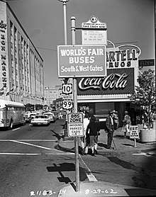
Within Downtown Seattle, US 99 was routed along 4th Avenue, connecting to the north with the Aurora Avenue expressway via 7th Avenue and to the south with East Marginal Way near Boeing Field.[51][52] An alternate route was designated in the early 1950s along 1st Avenue, rejoining the highway in Georgetown.[51] Congestion and difficulty in directing freight trucks through downtown led to proposals for a bypass route for US 99 as early as 1928 along Railroad Avenue on the city's waterfront.[46] Railroad Avenue, later renamed Alaskan Way, was rebuilt in the 1930s as part of the federal government's improvements to the city seawall and became the primary bypass route for through traffic, experiencing major congestion as a result.[46]
Formal proposals to build "motor viaducts" bypassing the city along Alaskan Way were submitted by the city engineering department in 1937 and supported by automobile and traffic safety groups.[53][54] The bypass viaduct gained popularity following the end of World War II and engineering work was approved in 1947, with construction funds sourced from the city and the Federal-Aid Highway Act of 1944.[55] A double-deck elevated design was chosen to accommodate the six lanes that would displace railroads along the east side of Alaskan Way.[55][56] Construction on the Alaskan Way Viaduct began on February 6, 1950, and the first section between Railroad Way and Elliott Avenue opened to traffic on April 4, 1953.[57][58] It cost approximately $8 million to construct, using pile-driven columns and a pair of moving gantry cranes to lift sections of the roadway from street level.[58][59]
The Battery Street Tunnel, connecting the viaduct with the Aurora Avenue expressway, was opened to traffic on July 24, 1954, and cost $2.8 million to construct.[60] A 2.3 miles (3.7 km) extension of the viaduct, linking south to a surface freeway and US 99 at East Marginal Way, cost $7.6 million to construct and opened on September 3, 1959.[61] The southern extension eased congestion at the Railroad Way terminus and was used by a daily average of 25,000 vehicles within days of opening and 37,000 vehicles by the end of the year.[57][62] A series of ramps connecting the viaduct to the Spokane Street Viaduct were completed in January 1960,[63] followed by a downtown offramp to Seneca Street in November 1961 and onramp from Columbia Street in February 1966.[64][65] The state government had prepared to build a set of ramps from the viaduct to US 10 (later part of I-90) near Connecticut Street,[66] but plans for the freeway were delayed in the 1960s and eventually abandoned,[67][68] leaving the ramps unused.[69][70]
The viaduct was initially signed as part of U.S. Route 99 Alternate and US 99 Bypass until 1959, when US 99 was formally switched to the viaduct after the completion of the southern extension.[71][72] 4th Avenue was signed as a business route of US 99 and also carried a section of US 10 to its terminus at the north end of the Battery Street Tunnel. The East Marginal Way route through the Boeing Field area was heavily congested due to traffic heading to Boeing facilities, leading to proposals in the 1950s to build a new expressway on the west side of the Duwamish River.[73] Construction of the two-lane West Marginal Way expressway began in November 1958 and was completed in July 1959, including grade-separated interchanges and bridges at South 118th Street, 14th Avenue South, and South Cloverdale Street.[74] The expressway split from US 99 at South 118th Street and connected to 1st Avenue at the south end of the viaduct using the First Avenue South Bridge, which opened in 1956 with the intent of becoming part of US 99.[75] In March 1959, the state government approved $3 million in funds for an expansion project that would widen the West Marginal Way expressway to four lanes.[76] The expansion was completed in 1968,[77][78] and was signed as US 99 Temporary and later State Route 99T after the 1964 state highway renumbering.[79]
Replacement and redesignation
The state legislature authorized planning of a tolled expressway from Tacoma to Everett in 1953, with the intent of building a grade-separated bypass of US 99.[80][81] The tollway plan was abandoned three years later in favor of Interstate Highway Program, which was authorized by the federal government and planned to construct a freeway system through the Seattle metropolitan area, including a route replacing US 99.[82] The route was designated as Interstate 5 in 1957 and planning for the Seattle Freeway began at the same time using federal funds.[83][84]
The first section of the Tacoma–Seattle–Everett freeway to be built was in southern Tacoma and was opened to traffic in October 1959. The Tacoma sections opened in October 1962 from the Puyallup River to the Kent–Des Moines Road in Midway,[85] and in October 1964 in downtown Tacoma.[86] Construction of the Seattle section began in 1958 with work on the Ship Canal Bridge, which was opened to traffic on December 18, 1962.[87] The northern approach to Downtown Seattle was opened the following August to coincide with the completion of the Evergreen Point Floating Bridge and SR 520. A 20-mile (32 km) section of the freeway traveling from North Seattle to southern Snohomish County and Everett was opened to traffic on February 3, 1965.[88] The freeway connecting Midway to the south side of Downtown Seattle was opened on January 31, 1967, completing the final section of the urban freeway.[89] I-5 itself was completed two years later with the opening of a section near Marysville on May 14, 1969.[90]
The state government introduced a new highway numbering system in 1964 to align with the Interstates and prepare for the decommissioning of U.S. routes. PSH 1 was replaced with US 99, which remained as a temporary designation on various freeway sections until I-5 was fully completed.[79] US 99 was decommissioned at a meeting of the American Association of State Highway Officials on June 24, 1969, shortly after the full completion of I-5 within Washington state.[91] During the 1970 codification of the new highway system, the state legislature created State Route 99 (SR 99) to delay transferring ownership and maintenance of the highway to local jurisdictions.[92][93] SR 99 was created from a section of US 99 running from Fife to the Broadway Interchange in Everett,[92] and was retained as a permanent addition to the state highway system in 1971.[94] A provision in the 1971 law allows for the abandonment of the Fife–Federal Way section of SR 99 after the completion of the SR 509 freeway extension.[94] Instead of continuing north into Everett on Evergreen Way, SR 99 was routed northeasterly on Everett Mall Way, a section of the Broadway Cut-off that opened in 1954,
To this day, an older US 99 sign is still in place on an overhead sign at the Columbia Street onramp to the Alaskan Way Viaduct in downtown Seattle.[95]
In 2004 the state legislature removed the SR 99 designation from the part of the route along Tukwila International Boulevard in Tukwila.[96]
The route is infamous for being lined with drug dealers, prostitutes, and strip clubs,[97] and the stretch of the route through south King County was where Gary Ridgway, aka the Green River Killer, picked up many of his victims.
Names and designations
In 1939, the Washington state legislature proposed naming the road "Jefferson Davis Highway", making it the final component of the Jefferson Davis Memorial Highway, which the United Daughters of the Confederacy intended to travel through the South and up the west coast to Canada, but it was never made official.[98][99] In 2002, the state's House of Representatives unanimously approved a bill that would have removed Davis' name from the road. However, a committee of the state's Senate subsequently killed the proposal.[100][101]
In May 2016, the highway was designated as the William P. Stewart Memorial Highway, named after an African-American Civil War veteran and early settler in Snohomish.[102]
Public transit
SR 99 is a major regional public transit corridor and is served by several bus routes and a light rail line.[103] The highway features bus lanes and business access and transit lanes (BAT lanes) in several locations to speed up bus trips.
Pierce Transit route 500 runs on the SR 99 and Pacific Highway corridor between Tacoma Dome Station and Federal Way Transit Center. Through Federal Way and SeaTac, the highway is served by the RapidRide A Line, which features stations with off-board fare payment. Link light rail trains on the Central Link run along elevated tracks above or near SR 99 from Angle Lake station to Tukwila International Boulevard station at the SR 518 interchange.[103] The Alaskan Way Viaduct carries several non-stop routes connecting Downtown Seattle to West Seattle (including the RapidRide C Line) and Burien.[103]
Aurora Avenue carries the RapidRide E Line, the most popular bus route in the King County Metro system, which debuted in 2014.[104] The E Line terminates near the county line at the Aurora Village Transit Center, where Community Transit's route 101 and Swift Blue Line begins. Swift features off-board fare payment and longer spacing between stops, and runs from Shoreline to Everett Station via Evergreen Way.[105] The Everett Mall Way section of SR 99 is served by Everett Transit route 7, which connects the Everett Mall to Downtown Everett and Everett Station.[103]
On November 27, 1998, a gunman shot and killed bus driver Mark McLaughlin on Seattle's 359 bus route, which ran down Highway 99. Soon after the incident, the route was renamed from 359 to 358.[106] Route 358 was later replaced with the E Line.
Major intersections
| County | Location | mi[1] | km | Destinations | Notes | ||
|---|---|---|---|---|---|---|---|
| Pierce | Fife | 0.00 | 0.00 | ||||
| Milton | 1.62 | 2.61 | Porter Way | Former SR 514 | |||
| King | Federal Way | 4.49 | 7.23 | ||||
| 7.72 | 12.42 | South end of SR 509 concurrency | |||||
| Des Moines | 11.84 | 19.05 | North end of SR 509 concurrency | ||||
| SeaTac | 15.11 | 24.32 | |||||
| SeaTac–Tukwila city line | 16.78 | 27.00 | Interchange | ||||
| Gap in route, continues as Tukwila International Boulevard | |||||||
| Tukwila | 16.79 | 27.02 | Continuation south | ||||
| South 116th Street / Tukwila International Boulevard | Interchange; south end of freeway section | ||||||
| 17.61 | 28.34 | West Marginal Place South | Northbound exit and entrance | ||||
| Seattle | 18.63 | 29.98 | Des Moines Memorial Drive / 14th Avenue South | ||||
| 19.22 | 30.93 | South Cloverdale Street | Northbound entrance only | ||||
| 19.56 | 31.48 | South Kenyon Street – South Park | Southbound exit and entrance | ||||
| 20.27 | 32.62 | Interchange; north end of freeway section | |||||
| Duwamish River | 20.27– 20.82 | 32.62– 33.51 | First Avenue South Bridge | ||||
| Seattle | 20.60 | 33.15 | |||||
| 22.65 | 36.45 | Spokane Street – West Seattle | Northbound exit and southbound entrance | ||||
| South end of Alaskan Way Viaduct | |||||||
| 22.74 | 36.60 | West Seattle Bridge – Harbor Island | Southbound exit and northbound entrance | ||||
| 24.24 | 39.01 | Southbound exit and northbound entrance | |||||
| Alaskan Way Tunnel north | Future south portal | ||||||
| 25.03 | 40.28 | Columbia Street | Southbound entrance only | ||||
| 25.04 | 40.30 | Seneca Street | Northbound exit only | ||||
| 25.69 | 41.34 | Western Avenue | |||||
| 25.78– 26.18 | 41.49– 42.13 | Battery Street Tunnel North end of Alaskan Way Viaduct | |||||
| 26.30 | 42.33 | Denny Way – Downtown Seattle | Southbound exit and northbound entrance | ||||
| 26.47 | 42.60 | Alaskan Way Tunnel south | Future north portal | ||||
| Lake Union | 27.91– 28.47 | 44.92– 45.82 | George Washington Memorial Bridge | ||||
| Seattle | 28.57 | 45.98 | North 38th Street | Interchange | |||
| 29.21 | 47.01 | North 46th Street | Interchange | ||||
| 30.04 | 48.34 | North 63rd Street / Green Lake Way | Interchange | ||||
| Seattle–Shoreline city line | 34.21 | 55.06 | |||||
| King–Snohomish county line | Shoreline–Edmonds city line | 37.23 | 59.92 | ||||
| Snohomish | Edmonds | 37.34 | 60.09 | Interchange | |||
| Lynnwood | 40.58 | 65.31 | |||||
| | 44.36 | 71.39 | Interchange | ||||
| Everett | 48.96– 49.13 | 78.79– 79.07 | |||||
| 49.13 | 79.07 | Continues north as Broadway | |||||
1.000 mi = 1.609 km; 1.000 km = 0.621 mi
| |||||||
References
- 1 2 3 Multimodal Planning Division (January 3, 2018). State Highway Log Planning Report 2017, SR 2 to SR 971 (PDF) (Report). Washington State Department of Transportation. pp. 761–793. Retrieved September 18, 2018.
- 1 2 Muhlstein, Julie (May 21, 2016). "Highway 99 renamed in honor of Snohomish settler William P. Stewart". The Everett Herald. Retrieved September 18, 2018.
- ↑ "State Highway National Highway System Routes in Washington" (PDF). Washington State Department of Transportation. 2017. Retrieved September 18, 2018.
- ↑ "What is the National Highway System?". Federal Highway Administration. January 31, 2017. Retrieved September 18, 2018.
- ↑ "Transportation Commission List of Highways of Statewide Significance" (PDF). Washington State Transportation Commission. July 26, 2009. Retrieved September 18, 2018.
- ↑ 2016 Annual Traffic Report (PDF) (Report). Washington State Department of Transportation. 2017. pp. 126–128. Retrieved September 18, 2018.
- ↑ McDonalds, Cathy (December 24, 2009). "History and a rare peat bog at West Hylebos Wetlands Park". The Seattle Times. p. D6. Retrieved September 18, 2018.
- 1 2 3 Google (September 25, 2017). "State Route 99 (southern segment)" (Map). Google Maps. Google. Retrieved September 25, 2017.
- 1 2 3 4 5 6 Washington State Department of Transportation (2014). Washington State Highways, 2014–2015 (PDF) (Map). Olympia, Washington: Washington State Department of Transportation. Puget Sound inset. Retrieved September 25, 2017.
- ↑ "House Bill Report: SB 5376" (PDF). Washington State Legislature. March 1, 2004. Retrieved September 18, 2018.
- 1 2 3 4 5 6 7 Google (September 27, 2017). "State Route 99 (northern segment)" (Map). Google Maps. Google. Retrieved September 27, 2017.
- ↑ Beers, Carole (February 2, 1997). "New Duwamish span opens while old one is fixed". The Seattle Times. p. B1.
- ↑ Lindblom, Mike (February 19, 2011). "The beginning of the end for the viaduct". The Seattle Times. p. B6. Retrieved September 18, 2018.
- ↑ "Tunnel closed after cement falls". The Seattle Times. October 27, 1995. p. B2.
- ↑ Lindblom, Mike (September 17, 2018). "Permanent closure of Alaskan Way Viaduct delayed until January". The Seattle Times. Retrieved September 18, 2018.
- ↑ Beason, Tyrone (November 25, 2015). "Seattle's gritty bridges are built for function, not beauty". The Seattle Times. Retrieved September 18, 2018.
- ↑ Lindblom, Mike (June 19, 2018). "Would the Golden Gate's 'Road Zipper' make Seattle's Aurora Bridge safer?". The Seattle Times. p. A1. Retrieved September 18, 2018.
- ↑ Dorpat, Paul (December 26, 2008). "Pedestrian overpass on Seattle's busy Aurora Avenue saves lives". The Seattle Times. Retrieved September 18, 2018.
- ↑ Broom, Jack (May 25, 1986). "The land of the hereafter: A cemetery has a life of its own". The Seattle Times. p. 12.
- ↑ Bock, Paula (December 9, 2007). "On the edge of opportunity: A community stretches for the buzz". The Seattle Times. p. 12. Retrieved September 18, 2018.
- ↑ Salyer, Sharon (August 28, 2017). "Edmonds has big plans for its Highway 99 improvements". The Everett Herald. Retrieved September 18, 2018.
- ↑ Smith, Evan (April 14, 2009). "A compromise for the 'Red Brick Road'". The Everett Herald. Retrieved September 18, 2018.
- ↑ Watkins, Amy (October 29, 2013). "New shopping center opens in Lynnwood". The Everett Herald. Retrieved September 18, 2018.
- ↑ Kugiya, Hugo (May 5, 2011). "Bibimbap's on the map in Koreatown North". Crosscut.com. Retrieved September 18, 2018.
- ↑ Flood, Chuck (2013). Washington's Highway 99. Charleston, South Carolina: Arcadia Publishing. p. 8. ISBN 978-0-7385-9618-1. OCLC 811603138. Retrieved October 6, 2018 – via Google Books.
- ↑ Meador, Karen (November 13, 2017). "Military Road: South King County's link to the Civil War". Federal Way Mirror. Retrieved October 7, 2018.
- ↑ "State Route 99 North/Aurora Avenue North Route Development Plan" (PDF). Washington State Department of Transportation. March 2003. p. 1. Archived from the original (PDF) on January 23, 2018. Retrieved October 7, 2018.
- ↑ "This Month in Edmonds History: North Trunk Road". My Edmonds News. October 1, 2013. Retrieved September 19, 2018.
- ↑ Crowley, Walt (September 19, 2000). "Interurban rail service between Everett and Seattle ends February 20, 1939". HistoryLink. Retrieved October 4, 2018.
- ↑ "Autoists Organize Highway Association". The Seattle Times. September 20, 1910. p. 9.
- 1 2 "Chapter 65: Classifying Public Highways" (PDF). Session Laws of the State of Washington, 1913. Washington State Legislature. March 12, 1913. p. 221. Retrieved October 4, 2018.
- ↑ Map of Washington State Highways Authorized by Legislative Acts of 1913, with 1915 changes (Map). 1 inch = 18 miles. Washington State Highway Commission. Retrieved October 7, 2018 – via Washington State University Libraries Digital Collection.
- ↑ "Chapter 185: Primary and Secondary State Highways" (PDF). Session Laws of the State of Washington, 1923. Washington State Legislature. March 19, 1923. pp. 627–628. Retrieved October 7, 2018.
- ↑ "Chapter 190: Establishment of Primary State Highways" (PDF). Session Laws of the State of Washington, Twenty-Fifth Session. Washington State Legislature. March 17, 1937. p. 933–943. Retrieved October 8, 2018.
- ↑ American Association of State Highway Officials (November 11, 1926). United States System of Highways Adopted for Uniform Marking by the American Association of State Highway Officials (Map). 1:7,000,000. Washington, D.C.: Bureau of Public Roads. OCLC 32889555. Retrieved October 7, 2018 – via University of North Texas Libraries.
- ↑ Cloud, Ray V. (1953). Edmonds, the Gem of Puget Sound. Edmonds Tribune-Review Press. p. 96. OCLC 26225475.
- ↑ "New Highway Shortens Trip; Everett Road Open Oct. 15". The Seattle Times. August 29, 1927. p. 20.
- ↑ "Washington" (Map). Rand McNally Junior Auto Road Atlas. 1:1,500,000. Rand McNally. 1927. pp. 82–83. OCLC 921180471. Retrieved October 7, 2018 – via David Rumsey Historical Map Collection.
- ↑ "New Highway To Tacoma To Clip Off Miles". The Seattle Times. January 15, 1928. p. 1.
- ↑ "One Side of New Highway To Tacoma To Be Paved". The Seattle Times. March 27, 1927. p. 14.
- ↑ "Bridge Traffic Is Problem; Two New Structures Favored". The Seattle Times. September 21, 1924. p. 1.
- ↑ Ross Gardner, James (June 29, 2011). "The Girl on the Bridge". Seattle Met. Retrieved October 8, 2018.
- ↑ "$1,500,000 State Aid Is Asked For Stone Way Span". The Seattle Times. January 26, 1927. p. 4.
- ↑ "New Bridge To Relieve Traffic on Fremont Span". The Seattle Times. March 6, 1928. p. 2.
- ↑ "Huge Crowd At Rites As Bridge Opens" (PDF). Seattle Post-Intelligencer. February 23, 1932. p. 13. Retrieved October 8, 2018.
- 1 2 3 Ott, Jennifer (September 13, 2011). "Alaskan Way Viaduct, Part 1: Early Transportation Planning". HistoryLink. Retrieved October 8, 2018.
- ↑ "Denny Regrade Intersections Draws Realty Interest". The Seattle Times. November 24, 1929. p. 32.
- ↑ "Aurora Avenue Will Be Thrown Wide Open Today". The Seattle Times. May 14, 1933. p. 3.
- ↑ "Map Shows Adequate Arteries To Aurora Span". The Seattle Times. October 5, 1930. p. 10.
- ↑ Oldham, Kit (February 17, 2007). "Seattle City Council votes to build Aurora Avenue through Woodland Park on June 30, 1930". HistoryLink. Retrieved October 8, 2018.
- 1 2 Rand McNally (1950). State of Washington Highway Map (Map). Washington State Highway Commission. Retrieved October 8, 2018 – via WSDOT Library Digital Collections.
- ↑ H.M. Gousha Company (1947). Street Map of Seattle (Map). 1 inch = 0.7 mi. Standard Oil of California.
- ↑ "Traffic Survey Urges Viaducts". The Seattle Times. December 2, 1937. p. 3.
- ↑ "Alaskan Way By-Pass Asked". The Seattle Times. June 30, 1938. p. 36.
- 1 2 Ott, Jennifer (October 27, 2011). "Alaskan Way Viaduct, Part 2: Planning and Design". HistoryLink. Retrieved October 8, 2018.
- ↑ Willix, Doug (May 11, 1947). "Alaskan Way Viaduct May Be 2-Decked". The Seattle Times. p. 17.
- 1 2 Ott, Jennifer (December 19, 2011). "First section of Seattle's Alaskan Way Viaduct opens on April 4, 1953". HistoryLink. Retrieved October 8, 2018.
- 1 2 "Alaskan Way Viaduct Opened To Traffic". The Seattle Times. April 5, 1953. p. 1.
- ↑ "Waterfront Viaduct To Be Finished in Fall". The Seattle Times. February 24, 1951. p. 2.
- ↑ Heilman, Robert (July 25, 1954). "Battery St. Subway Opened as Sefair Lane". The Seattle Times. p. 1.
- ↑ "Viaduct Extension Opened Officially". The Seattle Times. September 3, 1959. p. 1.
- ↑ "Congestion In Extension Of Viaduct Eased". The Seattle Times. September 9, 1959. p. 47.
- ↑ Ott, Jennifer (December 3, 2011). "Alaskan Way Viaduct, Part 3: Building the Viaduct". HistoryLink. Retrieved October 8, 2018.
- ↑ "Traffic Moves Smoothly in New Seneca St. Ramp". The Seattle Times. November 28, 1961. p. 4.
- ↑ Willix, Douglas (January 27, 1966). "Columbia St. Viaduct Ramp To Be Opened". The Seattle Times. p. 55.
- ↑ "Progress In Traffic-Relief Projects Told". The Seattle Times. December 19, 1955. p. 22.
- ↑ "Expressway-Link Need Cited". The Seattle Times. March 6, 1967. p. 24.
- ↑ Wilson, John; Wilson, Marshall (June 11, 1970). "Taxpayers Ante $4 Million For Abandoned Expressway". The Seattle Times. p. A1.
- ↑ Kelly, Tom (February 19, 1984). "Did voters kill solution to snarls?". The Seattle Times. p. D8.
- ↑ Ott, Jennifer (December 26, 2011). "Seattle's Columbia Street on-ramp to the Alaskan Way Viaduct opens to traffic on February 1, 1966". HistoryLink. Retrieved October 8, 2018.
- ↑ H.M. Gousha Company (1956). Shell Street Guide of Seattle and Tacoma (Map). 1 inch = 0.7 mi. Shell Oil Company. Retrieved October 8, 2018 – via David Rumsey Historical Map Collection.
- ↑ "Viaduct's Traffic Flow Changed". The Seattle Times. September 3, 1959. p. 21.
- ↑ "W. Marginal Way Expressway Changes O.K'd". The Seattle Times. July 10, 1957. p. 11.
- ↑ "Construction To Bypass Heavy Boeing Traffic To Be Completed Soon in South Seattle". Washington Highway News. 8 (7). August 1959. p. 19. OCLC 29654162. Retrieved October 9, 2018 – via WSDOT Library Digital Collections.
- ↑ Schear, Dwight (September 23, 1956). "Long-Awaited First Avenue South Bridge Opened". The Seattle Times. p. 4.
- ↑ Cunningham, Ross (March 22, 1959). "$160,000,000 State Highway Program Is Given Approval". The Seattle Times. p. 8.
- ↑ "Full Speed Ahead at Duwamish". Washington Highway News. 13 (2). July 1966. p. 15. OCLC 29654162. Retrieved October 9, 2018 – via WSDOT Library Digital Collections.
- ↑ "Construction Roundup". Washington Highway News. 15 (1). January 1968. p. 16. OCLC 29654162. Retrieved October 9, 2018 – via WSDOT Library Digital Collections.
- 1 2 C. G. Prahl (December 1, 1965). "Identification of State Highways" (PDF). Washington State Highway Commission. Retrieved October 9, 2018.
- ↑ Cunningham, Ross (February 3, 1952). "Knotty Financial, Traffic Problems Face Building Freeway Through Seattle". The Seattle Times. p. 12.
- ↑ Dugovich, William (May 1967). "Seattle's Superfreeway". Washington Highways. 14 (2). Washington State Department of Highways. pp. 2–5. OCLC 29654162. Retrieved October 9, 2018 – via WSDOT Library Digital Collections.
- ↑ Cunningham, Ross (December 5, 1956). "State High Court's Decision Means No Expressway Tolls". The Seattle Times. p. 15.
- ↑ Hittle, Leroy (October 9, 1957). "State's Two Major Highways To Be Renumbered In Defense System". Port Angeles Evening News. Associated Press. p. 1. Retrieved October 9, 2018 – via Newspapers.com.

- ↑ Becker, Paula (April 30, 2003). "First part of Seattle Freeway (Interstate 5) route receives federal funding on October 1, 1957". HistoryLink. Retrieved October 9, 2018.
- ↑ "Tacoma-Midway Link In Freeway Opened". The Seattle Times. October 10, 1962. p. 1.
- ↑ "Tacoma Freeway Section Dedicated". The Seattle Times. Associated Press. October 30, 1964. p. 26.
- ↑ Long, Priscilla (May 27, 2001). "Lake Washington Ship Canal Bridge (Interstate 5) opens to traffic in December 1962". HistoryLink. Retrieved October 10, 2018.
- ↑ Davis, Don (February 3, 1965). "New Freeway Now Open". The Everett Herald. p. A1.
- ↑ Heilman, Robert (January 31, 1967). "Ceremony Opens Final Freeway Link". The Seattle Times. p. 1.
- ↑ Mansfield, Tom (May 14, 1969). "I-5 Opened Today". The Everett Herald. p. A1.
- ↑ U.S. Route Numbering Subcommittee (June 24, 1969). "U.S. Route Numbering Subcommittee Agenda Showing Action Taken by the Executive Committee" (PDF) (Report). Washington, DC: American Association of State Highway Officials. p. 8. Retrieved September 16, 2018 – via Wikimedia Commons.
- 1 2 "Chapter 51: State Highways—Route Numbers" (PDF). Session Laws of the State of Washington, 1970 1st extraordinary session. Washington State Legislature. February 24, 1970. p. 356. Retrieved October 9, 2018.
- ↑ Burt, Lyle (May 23, 1969). "New Force Develops Against Highway Construction". The Seattle Times. p. 14.
- 1 2 "Chapter 73: State Highway Routes Numbers" (PDF). Session Laws of the State of Washington, 1971 1st extraordinary session. Washington State Legislature. May 18, 1971. p. 524. Retrieved October 9, 2018.
- ↑ Banel, Feliks (August 15, 2018). "Searching for 'ghost signs' in Seattle". KIRO Radio. Retrieved October 8, 2018.
- ↑ "47.17.160: State route No. 99". Revised Code of Washington. Washington State Legislature. 1970. Retrieved April 17, 2014.
revised 1971, 1979, 2004
- ↑ Sullivan, Jennifer (2008-01-17). "Prostitutes, drugs chased from Aurora corridor by group's patrols". Seattle Times.
- ↑ Berger, Knute (June 22, 2015). "Confederate symbols also blight the Northwest". Crosscut. Retrieved August 20, 2017.
- ↑ Ray, Susanna (January 24, 2002). "Jefferson Davis Highway here? Legislator outraged". The Everett Herald. Retrieved November 8, 2013.
- ↑ Verhovek, Sam Howe (February 14, 2002). "Road Named for Jefferson Davis Stirs Spirited Debate". The New York Times. Retrieved October 13, 2013.
- ↑ "Senate Committee Kills Plan To Rename Jefferson Davis Highway". KOMO News. Seattle, Washington: Sinclair Interactive Media. August 30, 2006. Retrieved July 21, 2016.
- ↑ Cornfield, Jerry (May 18, 2016). "SR 99 to be renamed for Snohomish black Civil War soldier". The Everett Herald. Retrieved May 18, 2016.
- 1 2 3 4 Regional Transit Map Book (PDF) (Map). Sound Transit. February 2014. pp. 8–11. Archived from the original (PDF) on July 28, 2017. Retrieved September 21, 2018.
- ↑ Lindblom, Mike (February 15, 2014). "Aurora Avenue North bus now RapidRide". The Seattle Times. Retrieved September 24, 2015.
- ↑ Lindblom, Mike (November 30, 2009). "Bus rapid transit launches today from Everett to Shoreline". The Seattle Times. Retrieved September 24, 2015.
- ↑ Argo, Jason (May 12, 2010). "In defense of the 358". Seattle Post-Intelligencer. Retrieved September 24, 2015.
External links
Route map: