SoDo, Seattle
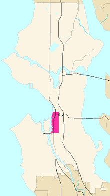
SoDo, alternatively SODO, is a neighborhood in Seattle, Washington, that makes up part of the city's Industrial District. It is bounded on the north by South King Street, beyond which is Pioneer Square; on the south by South Spokane Street, beyond which is more of the Industrial District; on the west by the Duwamish Waterway, across which is West Seattle; and on the east by Metro Transit's Downtown Seattle Transit Tunnel and SoDo Busway, beyond which is the International District and the rest of the Industrial District.
SoDo was originally named for being located south of the (King)dome, but since the stadium's demolition in 2000, the name has been taken to mean south of downtown.[1] The moniker was adopted in the 1990s after the renaming of the Sears building to the SODO Center (later Starbucks Center, the world headquarters of Starbucks at First Avenue S. and S. Lander Street).[2] It includes Seattle's downtown stadium district of Safeco Field (where Major League Baseball's Seattle Mariners play their home baseball games) and CenturyLink Field (built on the former Kingdome site; where the NFL's Seattle Seahawks play their home football games and Major League Soccer's Seattle Sounders FC play their home soccer matches).[3] The Mariners' popular marketing campaign in the early 2000s used the SoDo moniker in the catchphrase "SoDo Mojo".[4]
SoDo deliberately echoes SoHo in New York City, where, during the 1970s, cheap spaces vacated by departing factories were converted by artists into lofts and studios.[5] SoDo has undergone a similar process but has not experienced much of the gentrification experienced by its putative model. Some of SoDo's warehouse buildings remain in their original use; others have been carved up for artists' lofts, art galleries, and an assortment of other businesses. One building directly across from Safeco Field houses Pyramid Breweries, Inc. downstairs and a variety of small offices upstairs. As one travels farther south along First Avenue S., these conversions peter out, and light manufacturing, warehouses, and warehouse-style retail stores predominate.
Demographics
According to the 2000 U.S. Census, SoDo has a population of 2,602,[6] with a median age of 41.2; 458 residences are owner-occupied and 536 are rented. (This probably slightly understates the population, because there are a certain number of artists living illegally in studio spaces that are not zoned residential, plus a resident homeless population.) The average annual household income is given as $42,208; the racial breakdown is 41% White, 28% Asian, 14% Black, 9% Hispanic/Latino, 3% American Indian/Alaska Native, and 5% other.
Transportation
SoDo main thoroughfares are First and Fourth Avenues S. and Alaskan Way S. (north- and south-bound) and S. Lander and Holgate Streets, Edgar Martínez Drive S., and S. Royal Brougham Way (east- and west-bound). The western terminus of Interstate 90 is in SoDo, which travels 3,101 miles (4,991 km) east towards Boston, Massachusetts.
The neighborhood is also served by public transit service. Sound Transit operates Central Link light rail service through the neighborhood, stopping at two stations: SODO at Lander Street, and Stadium at Royal Brougham Way. The SODO Busway runs along 5th Avenue South and carries bus routes from King County Metro and Sound Transit Express.
References
- ↑ Moriwaki, Lee (June 21, 1997). "Starbucks, developer help boost SoDo area". The Seattle Times. p. C1. Retrieved January 16, 2017.
- ↑ "Yo, SODO". The Seattle Times. March 13, 1995. p. C1.
- ↑ Baker, Geoff (March 30, 2016). "Stadium officials ask for event-scheduling deal before upcoming Sodo arena vote". The Seattle Times. Retrieved January 16, 2017.
- ↑ Reader, Bill (October 3, 2000). "M's try to get their SoDo Mojo working". The Seattle Times. p. C8. Retrieved January 16, 2017.
- ↑ "Tacoma wants its own SoDo district". Seattle Daily Journal of Commerce. Associated Press. December 10, 1999. Retrieved January 16, 2017.
- ↑ "SoDo: 2012 Neighborhood Profile" (PDF). Downtown Seattle Association. September 2012. Archived from the original (PDF) on 2014-03-17. Retrieved January 16, 2017.
External links

- "SoDo rezone pits industry against developers", Seattle Daily Journal of Commerce, September 26, 2002.
- "It's gritty, blue-collar and sometimes home" Seattle Post-Intelligencer, April 11, 1998
- The proposed SODO Urban Art Corridor
- The SODO Business Association
| Wikimedia Commons has media related to SoDo, Seattle, Washington. |
Coordinates: 47°35′20″N 122°19′57″W / 47.58889°N 122.33250°W