Mercer Street
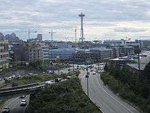 Mercer Street at Interstate 5 in 2014, looking west into South Lake Union offices | |
| Other name(s) | Mercer Place |
|---|---|
| Namesake | Thomas Mercer |
| Type | Arterial street |
| Maintained by | Seattle Department of Transportation |
| Length | 1.9 mi[1] (3.1 km) |
| Location | Seattle |
| West end | Elliot Avenue West in Interbay |
| Major junctions | Westlake Avenue in South Lake Union |
| East end |
|
Mercer Street is a major east–west thoroughfare in the Lower Queen Anne and South Lake Union neighborhoods of Seattle, Washington.
Route
Mercer Street begins as Mercer Place, at an intersection with Elliot Avenue West between the Elliott Bay waterfront and Kinnear Park on Queen Anne Hill. The narrow road travels southeast up a short hill to 5th Avenue West, where it turns due east onto West Mercer Street. The street passes through the built-up Lower Queen Anne neighborhood and widens to four lanes at Queen Anne Avenue.[1] Mercer Street continues east through the north part of the Seattle Center, passing the Seattle Repertory Theatre, McCaw Hall, and Memorial Stadium.[2] The street passes the headquarters of the Bill and Melinda Gates Foundation and gains a protected bike lane on its north side as it passes under Aurora Avenue North (State Route 99).[3] Mercer Street travels east through South Lake Union as a landscaped boulevard with six lanes,[4] passing between the campuses of Amazon.com and Google, to the south and north respectively.[5] The street crosses the path of the South Lake Union Streetcar at Westlake and Terry avenues, just south of Lake Union Park and the Museum of History and Industry.[6] After Fairview Avenue, Mercer enters an interchange with Interstate 5, with direct ramps to the freeway and its reversible express lanes.[1][7]
History
Mercer Street, named for settler Thomas Mercer, was planned in the early 1860s as part of the initial street grid of Lower Queen Anne. A wagon road along what is now Mercer Street was constructed between Lower Queen Anne and Farm Street (later Aurora Avenue) in 1885.[8]
References
- 1 2 3 Google (September 9, 2017). "Mercer Street" (Map). Google Maps. Google. Retrieved September 9, 2017.
- ↑ Seattle Center Campus Map (PDF) (Map). Seattle Center. July 18, 2017. Retrieved September 9, 2017.
- ↑ Mercer West and North Portal (SR 99 Tunnel) Improvements (PDF) (Map). Seattle Department of Transportation. 2013. Retrieved September 9, 2017.
- ↑ Lindblom, Mike (August 23, 2012). "Mercer gets 6 lanes, two-way traffic Monday". The Seattle Times. Retrieved September 9, 2017.
- ↑ Lerman, Rachel (March 24, 2016). "Google plans big expansion in South Lake Union". The Seattle Times. Retrieved September 9, 2017.
- ↑ Corr, O. Casey (August 17, 2007). "The $29.6 million semi-secret on the shores of Seattle's Lake Union". Crosscut.com. Retrieved September 9, 2017.
- ↑ "SR 5 - Exit 167: Mercer St/Lakeview Blvd" (PDF). Washington State Department of Transportation. February 29, 2012. Retrieved September 9, 2017.
- ↑ Lentz, Florence K.; Sheridan, Mimi (October 2005). "Queen Anne Historic Context Statement" (PDF). Seattle Department of Neighborhoods. pp. 4–6. Archived from the original (PDF) on July 14, 2016. Retrieved September 9, 2017.
External links
| Wikimedia Commons has media related to Mercer Street, Seattle. |