Wallingford, Pennsylvania
| Wallingford, Pennsylvania | |
| Settlement | |
 Wallingford post office | |
| Country | United States |
|---|---|
| State | Pennsylvania |
| County | Delaware |
| Township | Nether Providence |
| Elevation | 131 ft (39.9 m) |
| Coordinates | 39°53′27″N 75°21′47″W / 39.89083°N 75.36306°WCoordinates: 39°53′27″N 75°21′47″W / 39.89083°N 75.36306°W |
| Timezone | EST (UTC-5) |
| - summer (DST) | EDT (UTC-4) |
| ZIP code | 19086 |
| Area code | 484, 610 |
 Location of Wallingford in Pennsylvania  Wallingford, Pennsylvania (the US) | |
| Website: www | |
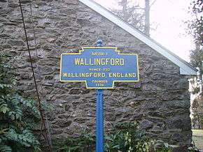
Wallingford is an unincorporated community in Nether Providence Township, Delaware County in Pennsylvania, United States. Founded in 1687, it is named for Wallingford, England. In 2007, Wallingford was named by Money Magazine as the 9th best place to live in the United States; two other towns in the area made the top 15.[1] Most locations in Nether Providence use Wallingford's zip code.
It is west of Interstate 476 (known locally as the "Blue Route") and east of S. Providence Road, PA 252. Crum Creek forms the township's eastern border with the borough of Swarthmore. Wallingford lies north of Chester on the southwest edge of the Philadelphia urban area. Wallingford is about 9 miles from Philadelphia proper.
The first area school started in 1810 and was built on a portion of a 78-acre (32 ha) land grant of farmer and friend of William Penn. Nether Providence School District was formed in 1856; it merged with the Swarthmore School District in 1984, creating the Wallingford Swarthmore School District. The Helen Kate Furness Library was founded in 1902.
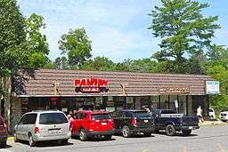
Located in Wallingford is the Helen Kate Furness Free Library,[2] which was renovated in 2006. There is a dry cleaning shop and a post office. Various doctors, dentists and lawyers are also located in Wallingford.
About half a dozen churches and chapels of several denominations are located in Wallingford, including Wallingford Presbyterian Church,[3] St. John Chrysostom Catholic Church on Providence Road and the Foundry Church,[4] near Media Parkway. Wallingford is also home to Congregation Ohev Shalom,[5] a conservative synagogue located at the corner of Rt. 252 and Rt. 320.

The local school district is the Wallingford-Swarthmore School District, which serves Wallingford, Swarthmore, Rutledge, and parts of Media, Morton and Rose Valley.
Wallingford is located along SEPTA's Media/Elwyn Line, and has a station whose design is attributed to the well-known Victorian architect Frank Furness. Wallingford is about 30 minutes from center city Philadelphia by rail. Effective July 1, 2013, the one-way ticketed fares are $5.75 weekdays and $5.00 evenings and weekends. On-board cash fares are $7.00 at all times.
The township's municipal offices are located at 214 Sykes Lane.
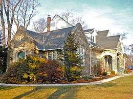
The Thomas Leiper Estate, Westlawn and Wolley Stille are listed on the National Register of Historic Places.[6]
Demographics
As of the census of 2010, there were 11,420 people residing in Zip Code Tabulation Area 19086. The population density was 3,095 people per square mile. There were 4,487 housing units. The racial makeup of the community was 90.03% White, 4.57% African American, 0.55% Native American, 5.07% Asian, 0.09% Pacific Islander. 1.95% of the population were Hispanic or Latino of any race. The median age was 44.5 years. The median income for a household in the town was $100,660.[7]
Points of interest
- Pendle Hill Quaker Center for Study and Contemplation
- Taylor Memorial Arboretum
- Community Arts Center
- Saint John Chrysostom R.C.
Notable residents
- Edward Potts Cheyney (1861-1947), American historical and economic writer
- Jay Clayton (attorney) Chairman of the SEC
- Dan Connor (born 1985), former American football linebacker
- Ida Dixon (1854-1916), American golf course architect
- Horace Howard Furness (1833-1912), Shakespearean scholar
Neighborhoods
- Pendlehill
- Avonbrook
- Ridgewood
- South Summit
- Wallingford
- South Wallingford
- East Wallingford
- Bowling Green
- Pine Ridge
- Heatherwold
References
- ↑ Three Local Towns Make Top 15 Places To Live, Wallingford Makes Top 10
- ↑
- ↑ Wallingford Presbyterian Church
- ↑ The Foundry Church
- ↑ Congregation Ohev Shalom
- ↑ National Park Service (2010-07-09). "National Register Information System". National Register of Historic Places. National Park Service.
- ↑ "American FactFinder". United States Census Bureau. Retrieved August 17, 2015.
External links
| Wikimedia Commons has media related to Wallingford, Pennsylvania. |
Municipalities and communities of Delaware County, Pennsylvania, United States | ||
|---|---|---|
| City | 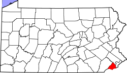 | |
| Boroughs | ||
| Townships | ||
| CDPs | ||
| Unincorporated communities |
| |
| Ghost town | ||
| Footnotes | ‡This populated place also has portions in an adjacent county or counties | |