Ville-Marie, Montreal
| Ville-Marie | ||
|---|---|---|
| Borough of Montreal | ||
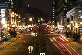 A view of McGill College Avenue in December. | ||
| ||
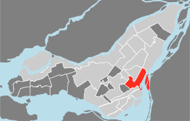 Location of Ville-Marie on the Island of Montreal. (Grey areas indicate demerged municipalities). | ||
| Country |
| |
| Province |
| |
| Region |
| |
| Established | January 01, 2002 | |
| Electoral Districts Federal |
Ville-Marie—Le Sud-Ouest—Île-des-Sœurs Laurier—Sainte-Marie Outremont | |
| Provincial |
Westmount–Saint-Louis Sainte-Marie–Saint-Jacques Hochelaga-Maisonneuve Saint-Henri–Sainte-Anne | |
| Government[1][2][3] | ||
| • Type | Borough | |
| • Mayor | Valérie Plante | |
| • Federal MP(s) |
Marc Miller (LIB) Hélène Laverdière (NDP) Thomas Mulcair (NDP) | |
| • Quebec MNA(s) |
Jacques Chagnon (PLQ) Manon Massé (QS) Carole Poirier (PQ) Marguerite Blais (PLQ) | |
| Area[4] | ||
| • Total | 16.5 km2 (6.4 sq mi) | |
| Population (2011)[4] | ||
| • Total | 84,013 | |
| • Density | 5,085.5/km2 (13,171/sq mi) | |
| Time zone | UTC-5 (EST) | |
| • Summer (DST) | UTC-4 (EDT) | |
| Area code(s) | (514) and (438) | |
| Access Routes[5] |
| |
| Website | www.ville.montreal.qc.ca/villemarie | |
Ville-Marie is the name of a borough (arrondissement) in the centre of the city of Montreal, Quebec. The borough is named after Fort Ville-Marie, the French settlement that would later become Montreal (now Old Montreal), which was located within the present-day borough. Old Montreal is a National Historic Site of Canada.
The borough comprises all of downtown Montreal, including the Quartier des spectacles; Old Montreal and the Old Port; the Centre-Sud area; most of Mount Royal Park as well as Saint Helen's Island and Île Notre-Dame.
In 2011, it had a population of 84,013 and an area of 16.5 square kilometres (6.4 sq mi).[4]
Geography
It is bordered by the city of Westmount (along Atwater Street) to the west and the boroughs of Le Sud-Ouest (along the Ville-Marie Autoroute, Guy and Notre-Dame streets, and the Bonaventure Autoroute) to the southwest, Mercier–Hochelaga-Maisonneuve (along the CP rail lines) to the east, Le Plateau-Mont-Royal (along Sherbrooke, University streets, and Pine and Park avenues) to the northeast, and Outremont and Côte-des-Neiges—Notre-Dame-de-Grâce (along the border of Mount Royal Park) to the north. It is bounded on the south by the Saint Lawrence River.
Government
Borough council
The borough council of Ville-Marie differs from other borough councils in two important respects. The office of borough mayor, rather than being elected by the borough's citizens, is held ex officio by the mayor of Montreal. Also, two of the members of the borough council are city councillors from other boroughs, chosen by the mayor. This governing structure is due to the unique status of Ville-Marie as the centre of Montreal.
Following the 2017 Montreal municipal election, the Ville-Marie borough council contains the following members:
| District | Position | Name | Party | |
|---|---|---|---|---|
| — | Borough mayor (as mayor of Montreal) |
Valérie Plante | Projet Montréal | |
| Peter-McGill | City councillor | Cathy Wong | Équipe Coderre | |
| Saint-Jacques | City councillor | Robert Beaudry | Projet Montréal | |
| Sainte-Marie | City councillor | Sophie Mauzerolle | Projet Montréal | |
| — | Borough councillors (appointed by the mayor from Montreal City Council) |
Anne-Marie Sigouin (City councillor for Saint-Paul–Émard–Saint-Henri-Ouest, Le Sud-Ouest) |
Projet Montréal | |
| Richard Ryan (City councillor for Mile End, Le Plateau-Mont-Royal) |
Projet Montréal |
Rather than a dedicated borough hall, the borough's offices and council chambers are located in the Place Dupuis office tower at 800 De Maisonneuve Boulevard East.
Former council composition
Up until the 2009 municipal election, Ville-Marie's borough council had a structure more similar to other boroughs, consisting of a borough mayor, two city councillors, and two borough councillors, all of whom were elected by residents of the borough.
When the 2009 election was called, the borough council consisted of the following councillors:
- Borough mayor: Benoit Labonté (Vision Montreal)
- Sainte-Marie—Saint-Jacques: City Councillor: Sammy Forcillo (Union Montreal); Borough Councillor: Pierre Mainville (Projet Montréal)
- Peter-McGill: City Councillor: Catherine Sévigny (Union Montreal); Borough Councillor: Karim Boulos (Independent)
The 2009 election saw the coming into force of Bill 22 (2008), An Act to amend various legislative provisions concerning Montréal. As a result, the borough council now consists of the mayor of Montreal; three elected city councillors representing the districts of Peter-McGill, Sainte-Marie, and Saint-Jacques; and two city councillors representing other districts in Montreal, chosen by the mayor.
Federal and provincial
The borough is divided among the following federal ridings:
It is divided among the following provincial electoral districts:
- Westmount–Saint-Louis
- Sainte-Marie–Saint-Jacques
- Hochelaga-Maisonneuve
- Saint-Henri–Sainte-Anne
- Outremont (three small corners of Mount Royal Park to the borough's northeast)
Demographics
| Historical populations | ||
|---|---|---|
| Year | Pop. | ±% |
| 1966 | 110,988 | — |
| 1971 | 93,735 | −15.5% |
| 1976 | 77,409 | −17.4% |
| 1981 | 70,669 | −8.7% |
| 1986 | 69,159 | −2.1% |
| 1991 | 68,894 | −0.4% |
| 1996 | 71,788 | +4.2% |
| 2001 | 74,832 | +4.2% |
| 2006 | 78,876 | +5.4% |
| 2011 | 84,013 | +6.5% |
| [6] | ||
| Language | Population | Percentage (%) |
|---|---|---|
| French | 42,350 | 54% |
| English | 20,735 | 27% |
| Other languages | 14,865 | 19% |
Neighbourhoods
Ville-Marie includes the city's downtown, the historical district of Old Montreal, Le Quartier Chinois, the Gay Village, the Latin Quarter, the recently gentrified Quartier international and Cité Multimédia as well as the Quartier des Spectacles which is currently under development. Other neighbourhoods of interest in the borough include the affluent Golden Square Mile and Îlot-Trafalgar-Gleneagles at the foot of Mount Royal and the Shaughnessy Village/Quartier Concordia area home to thousands of students at Concordia University. The borough also comprises most of Mount Royal Park, Cité du Havre, Saint Helen's Island, and Île Notre-Dame.
Transportation
Montreal's interurban rail and bus terminals, and its two commuter rail terminals (Central Station, Lucien-L'Allier and the Downtown Terminus) are in the borough. It is served by the Orange, Green, and Yellow Lines of the Montreal Metro. The Metro's central station, Berri-UQAM (which is a terminus of the Yellow Line), and the Central Bus Station, are also located in Ville-Marie.
Two autoroutes serve the area: Autoroute Bonaventure and the partly underground Autoroute Ville-Marie. Two bridges — the Victoria Bridge and Jacques-Cartier Bridge — provide access to the South Shore, while the Pont de la Concorde provides access to Saint Helen's Island and Notre Dame Island (Parc Jean-Drapeau). The Jacques-Cartier Bridge also provides access to Saint Helen's Island and Notre Dame Island.
Attractions
Many of Montreal's most famous attractions are situated in Ville-Marie. Most of its office towers, including 1000 de La Gauchetière, 1250 René-Lévesque, the Tour de la Bourse, Place Ville-Marie, the Sun Life Building, the Maison Radio-Canada, and many others are located here.
Three of Montreal's four universities — McGill, Concordia, and UQAM — are located in Ville-Marie, as are three of its four basilicas — Mary, Queen of the World Cathedral, Notre-Dame Basilica, and St. Patrick's Basilica. Cultural infrastructure includes Grande Bibliothèque du Québec, Place des Arts, the Montreal Museum of Fine Arts, the Quartier des spectacles, the Montreal Science Centre, Pointe-à-Callière Museum, Musée Grévin Montreal, and numerous other important venues.
Sports complexes include the Bell Centre, home of the Montreal Canadiens; the Percival Molson Stadium, home of the Montreal Alouettes; and the Circuit Gilles Villeneuve on Île Notre-Dame, site of the Canadian Grand Prix.
Hospitals include the Centre hospitalier de l'Université de Montréal (CHUM) megahospital, opened in 2017, as well as the Montreal General Hospital and Hôpital Notre-Dame.
Major parks and recreation areas include Mount Royal and its park, Parc Jean-Drapeau (the site of Expo 67), Dorchester Square and Place du Canada, and the Old Port.
Economy
As Ville-Marie contains Montreal's central business district, numerous companies are headquartered or have major regional offices in the borough, including Bombardier Aerospace.[8]
Education
The Commission scolaire de Montréal (CSDM) operates French-language public schools.
The English Montreal School Board (EMSB) operates English-language schools.
The Montreal Public Libraries Network operates the Frontenac and Père-Ambroise libraries.
Climate
| Climate data for Ville-Marie, Montreal | |||||||||||||
|---|---|---|---|---|---|---|---|---|---|---|---|---|---|
| Month | Jan | Feb | Mar | Apr | May | Jun | Jul | Aug | Sep | Oct | Nov | Dec | Year |
| Average high °C (°F) | −4.9 (23.2) |
−3.7 (25.3) |
2.6 (36.7) |
11.1 (52) |
19.2 (66.6) |
23.8 (74.8) |
26.8 (80.2) |
25.2 (77.4) |
19.9 (67.8) |
12.7 (54.9) |
5.4 (41.7) |
−1.9 (28.6) |
11.4 (52.4) |
| Daily mean °C (°F) | −8.8 (16.2) |
−7.4 (18.7) |
−1.3 (29.7) |
6.8 (44.2) |
14.4 (57.9) |
18.8 (65.8) |
22.4 (72.3) |
20.8 (69.4) |
15.7 (60.3) |
9.1 (48.4) |
2.5 (36.5) |
−5.5 (22.1) |
7.3 (45.1) |
| Average low °C (°F) | −12.6 (9.3) |
−11.1 (12) |
−5.1 (22.8) |
2.5 (36.5) |
9.6 (49.3) |
14.7 (58.5) |
17.8 (64) |
16.4 (61.5) |
11.6 (52.9) |
5.5 (41.9) |
−0.6 (30.9) |
−9.1 (15.6) |
3.3 (37.9) |
| Average precipitation mm (inches) | 77.7 (3.059) |
64.2 (2.528) |
78.8 (3.102) |
76.6 (3.016) |
88.6 (3.488) |
94.7 (3.728) |
97.6 (3.843) |
107.8 (4.244) |
90.1 (3.547) |
83.5 (3.287) |
90.9 (3.579) |
102.9 (4.051) |
1,053.4 (41.472) |
| Source: Environment Canada (normals, 1971-2000) [9] | |||||||||||||
See also
| Wikimedia Commons has media related to Ville-Marie. |
Places adjacent to Ville-Marie, Montreal | |
|---|---|
References
- ↑ "Ministère des Affaires Municipales et Régions: Ville-Marie (Montreal)". gouv.qc.ca. Retrieved 13 April 2018.
- ↑ "History of Federal Ridings since 1867". www2.parl.gc.ca. Retrieved 13 April 2018.
- ↑ "Chief Electoral Officer of Québec - 40th General Election Riding Results: WESTMOUNT--SAINT-LOUIS]
[http://www.electionsquebec.qc.ca/en/resultats_gen.asp?bsq=Sainte-Marie-Saint-Jacques§ion=resultats_gen&even='2008'&mode='n3'#resul Chief Electoral Officer of Québec - 40th General Election Riding Results: SAINTE-MARIE--SAINT-JACQUES]
[http://www.electionsquebec.qc.ca/en/resultats_gen.asp?bsq=Hochelaga-Maisonneuve§ion=resultats_gen&even='2008'&mode='n3'#resul Chief Electoral Officer of Québec - 40th General Election Riding Results: HOCHELOGA-MAISONNEUVE]
[http://www.electionsquebec.qc.ca/en/resultats_gen.asp?bsq=Saint-Henri-Sainte-Anne§ion=resultats_gen&even='2008'&mode='n3'#resul Chief Electoral Officer of Québec - 40th General Election Riding Results: SAINT-HENRI--SAINTE-ANNE". electionsquebec.qc.ca. Retrieved 13 April 2018. External link in|title=(help) - 1 2 3 "Population totale en 2006 et en 2011 - Variation — Densité" (PDF). Canada 2011 Census (in French). Ville de Montréal. 2012. Retrieved 5 June 2012.
- ↑ transports, Gouvernement du Québec, Ministère des Transports, de la Mobilité durable et de lÉlectrification des. "Québec 511 - Carte routière". www.quebec511.gouv.qc.ca. Retrieved 13 April 2018. C1 control character in
|first=at position 81 (help) - ↑ "Profil sociodéographique: Arrondissement de Ville-Marie" (PDF) (in French). Ville de Montréal. 2013. Retrieved 28 October 2013.
- ↑ "Ville de Montréal - Montréal en statistiques - Ville-Marie". ville.montreal.qc.ca. Retrieved 13 April 2018.
- ↑ "Contacts." Bombardier Aerospace. Retrieved on September 14, 2009.
- ↑ "Canadian Climate Normals 1971-2000 Station Data". Environment Canada. Retrieved June 7, 2014.
External links
- Borough's website (in French for now)
- All Ville-Marie skyscrapers on IMTL website
Coordinates: 45°30′31″N 73°33′46″W / 45.508556°N 73.562846°W