Snowdon, Montreal
| Snowdon | |
|---|---|
| Neighbourhood | |
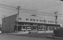
.jpg) The Snowdon Theatre is an art deco landmark in the Snowdon neighbourhood. | |
|
Snowdon Location of Snowdon in Montreal | |
| Coordinates: 45°29′01″N 73°37′45″W / 45.483687°N 73.629107°WCoordinates: 45°29′01″N 73°37′45″W / 45.483687°N 73.629107°W | |
| Country | Canada |
| Province | Quebec |
| City | Montreal |
| Borough | Côte-des-Neiges–Notre-Dame-de-Grâce |
| Population (2006)[1] | |
| • Total | 32,160 |
Snowdon is a neighbourhood located in Montreal, Quebec, Canada. It is part of the Côte-des-Neiges–Notre-Dame-de-Grâce borough. The area is centred on the intersection of the Décarie Expressway and Queen Mary Road.
Snowdon is bordered by Macdonald Street (Hampstead) in the west, Victoria Avenue (Côte-des-Neiges) in the east, Côte-Saint-Luc Road (Notre-Dame-de-Grâce) to the south and Vezina Street and the railway tracks (Le Triangle) to the north.[2] Furthermore, the northwest end borders Côte Saint-Luc and the southeast end borders Westmount.
The neighbourhood is served by the Snowdon Metro, which has access to the Metro's Orange Line and Blue Line[3]. Notable buildings in the neighbourhood include the former Snowdon Theatre.
The district was named for James Snowdon, who owned a farm where the neighbourhood now stands.[4][5]
References
- ↑ "Snowdon" (PDF). Profil de district électoral. Retrieved 9 May 2013.
- ↑ "Snowdon en photos" (in French). GrandQuebec.com. Retrieved 1 April 2012.
- ↑ "Snowdon". Société de transport de Montréal. Retrieved 2018-09-22.
- ↑ Rootsweb
- ↑ "Snowdon - Québec". ProvinceQuebec.com. Retrieved 1 April 2012.
Places adjacent to Snowdon, Montreal | |
|---|---|