Centre-Sud
| Centre-Sud | |
|---|---|
| Neighbourhood | |
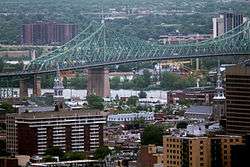 The Centre-Sud neighbourhood around the Jacques Cartier Bridge | |
|
Centre-Sud Location of Centre-Sud in Montreal | |
| Coordinates: 45°31′25″N 73°33′07″W / 45.523565°N 73.55187°WCoordinates: 45°31′25″N 73°33′07″W / 45.523565°N 73.55187°W | |
| Country | Canada |
| Province | Quebec |
| City | Montreal |
| Borough | Ville-Marie |
The Centre-Sud neighbourhood is located at the eastern most edge of the Ville-Marie borough of the city of Montreal, Quebec, Canada. The neighbourhood is bordered by the Saint Lawrence River to the south, Saint Hubert Street to the west, the Canadian Pacific rail line to the east and Sherbrooke Street to the north. The Plateau is located to the north, and Mercier-Hochelaga-Maisonneuve is located to the east.
The Centre-Sud is home to Montreal's Gay Village and to the Sainte-Marie neighbourhood.
Transportation
The neighbourhood is accessible by the following Montreal Metro stations. Frontenac, Papineau, Beaudry and Berri-UQAM.
External links
This article is issued from
Wikipedia.
The text is licensed under Creative Commons - Attribution - Sharealike.
Additional terms may apply for the media files.