Little Burgundy
| Little Burgundy La Petite-Bourgogne | |
|---|---|
| Neighbourhood | |
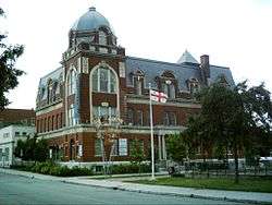 Edifice Georges Vanier | |
|
Little Burgundy Location of Little Burgundy in Montreal | |
| Coordinates: 45°29′07″N 73°34′33″W / 45.485209°N 73.575954°WCoordinates: 45°29′07″N 73°34′33″W / 45.485209°N 73.575954°W | |
| Country | Canada |
| Province | Quebec |
| City | Montreal |
| Borough | Le Sud-Ouest |
| Established | 1864 |
| Population (2011)[1] | |
| • Total | 10,046 |
_22-09-2006.JPG)
Little Burgundy (French: La Petite-Bourgogne) is a neighbourhood in the Sud-Ouest borough of the city of Montreal, Quebec, Canada.
Geography
Its approximate boundaries are Atwater Street to the west, Saint-Antoine to the north, Guy Street to the east, and the Lachine Canal to the south.
The adjacent neighbourhoods are the borough of Ville-Marie and downtown Montreal to the north and northeast, Griffintown to the southeast, Pointe-Saint-Charles to the south, and Saint-Henri to the west.
The neighborhood comprises the former city of Sainte-Cunégonde and Saint-Joseph's ward.
Name
There are differing accounts of the origin of the name Little Burgundy (Petite-Bourgogne). A surveyor's map of 1855 identifies a property called Bourgogne, owned by the heirs of the Hon. Louis Guy (brother of Étienne Guy, for whom Guy Street was named). The property corresponds to the areas bounded today by Rue des Seigneurs, Rue Notre-Dame, Rue Saint-Martin, and Rue Saint-Antoine.[2].
Official use of the name "Petite Bourgogne" originates from the 1965 preliminary study for the urban renewal program to refer to the area between the Lachine Canal, the CN railway (today the Ville-Marie Expressway), Atwater street and Guy Street in the 1965 preliminary study for the urban renewal program.[3] The report takes inspiration from the writing of E.Z. Massicotte, archivist of the City of Montreal and resident of Sainte-Cunégonde, who described the area as a meadow known as "la petite Bourgogne."[4] The authors of the urban renewal study "kept this name, full as it is of poetry and nostalgia for another landscape,"[3] and this name was retained as the name of the neighborhood after the renewal program ended.
In the early 1980s, the City of Montreal renamed Little Burgundy to Quartier Georges-Vanier, after the Governor General Georges Vanier, in an attempt to remove the stigma of the low-income area which public officials believed was deterring investment from private developers.[5] During the public consultations for the City of Montreal's Master Plan (Plan d'urbanisme) in 1990, residents requested that the name Petite Bourgogne/Little Burgundy be reinstated.[6]
History
Pre-industrial history
Essentially agricultural until 1810, today's Little Burgundy began to be built up the ward of St. Joseph, a faubourg spreading outside the city walls. The area around Richmond Square was built up in 1819.[7]
Early industrial period
Development accelerated in the mid-19th century with the construction of the Lachine Canal attracted many so-called "smokestack" industries, most notably the Canadian Pacific Railway yards, and the Steel Company of Canada (or Stelco) plant, among others. A residential sector was built north of the factories between 1857 and 1864. Originally part of the parish of Saint-Henri-des-Tanneries, it was set up as the village of Delisle in 1864,[8] then Sainte-Cunégonde in 1876, becoming a town in 1884.[9] The name derived from St. Cunigunde of Luxembourg, wife of St. Henry II, Holy Roman Emperor, a reference to the neighbouring parish.[10]
The industrial development along the Lachine Canal attracted many prestigious businesses to set up in the Ward of St. Joseph along Rue Notre-Dame, resulting in the construction of many handsome buildings which are the mainstay of today's antiques district.[11]
Sainte-Cunégonde was absorbed into the city of Montreal in 1906; the former town hall is now a public library and community centre, located on Vinet Street. Sainte-Cunégonde was bounded by the Lachine Canal, Atwater Avenue, Dorchester Street (now Boul. René-Lévesque), and a straight line from the corner of Atwater and Tupper streets to the basin of the Lachine Canal just west of the St. Gabriel locks. Saint-Joseph Ward was bordered by that line, St. Antoine Street, Victoria Square, McGill Street, and Notre-Dame Street. At this time, the Grand Trunk Railway ran directly through the area, terminating at St. Bonaventure Station.[12]
Deindustrialization and urban renewal
Already hurt by the Great Depression before the war,[11] like the rest of the area around the Lachine Canal Little Burgundy was hit hard by the opening of the St. Lawrence Seaway in 1956 and the closure of the Lachine Canal in 1970; numerous industries left for the suburbs, leaving the area in a state of decay.
In 1966, the City of Montreal launched a large urban renewal project in Little Burgundy,demolishing countless condemned dwellings and replacing them with public housing developments,[8] while revitalizing other parts of the neighbourhood.[9] In addition to the demolitions for the municipal urban renewal program, the part of the neighbourhood north of Rue Saint-Antoine were demolished in 1970 to make room for the Ville-Marie Expressway, a provincial project.[7] Between Little Burgundy and Saint-Henri, 1160 households were evicted for the expressway.[13] The demolitions resulted in a dramatic displacement of the residents.[14] [15]
Between 1968 and 1978, 1441 units of low-income public housing were constructed in Little Burgundy,[16] beginning with Habitations Îlots Saint-Martin (Saint Martin's Blocks). Although Habitations Jeanne-Mance was the first public housing project in Montreal, Îlots Saint-Martin was the first public housing under Quebec's provincial housing authority (Société d'habitation du Québec), and managed by the municipal housing office (Office municipal d'habitation de Montréal).[17]
In 1991 public housing comprised 39.3% of all housing in Little Burgundy, and nearly 55% of rental housing.[16]
Post-renewal and gentrification
Today, the neighbourhood has endured several phases of gentrification. The sociodemographic profile of the neighbourhood has changed substantially. In the 1960s, 90% of Little Burgundy residents were renters.[3] By 1991, 30% of dwellings were owner occupied.[18] Devertreuil writes that "Petite Bourgogne saw a 200% increase in administrators and professionals between 1981 and 1986, compared to a 39% increase in St. Henri and a 16% increase in Cote St. Paul."[13]
By the end of the 1970s, Little Burgundy's urban renewal program had failed to attract the levels of private development anticipated. As much as one third of the land was vacant by the end of the 1970s.[13] In the 1980s, Little Burgundy became one of the targets of the programs Opération 10,000 and 20,000 Logements (Operation 10,00/20,000 Homes), which aimed to increase property tax revenue by bringing a stable homeowner population back to the city.[19] The Logements programs auctioned lots from the public land bank, much of which had been acquired through the renewal program, to private developers at below-market rates.[19] The land acquired from the removal of the CN railyards in 1982 also figured in the new construction. Between 1980 and 1986, 1179 housing units were constructed through the Logements programs, of which 233 were non-profit or cooperative housing.[20] Many of the townhouses in Little Burgundy were constructed through the Logements programs, as well as the Foyer Hongrois home for the elderly.[20]
The redevelopment of the Lachine Canal into a linear recreational park during the 1980s and 1990s and the conversion of industrial buildings along its shores into condominiums also contributed to the shifting socio-demographi profile of the neighbourhood. Other factors contributing to the gentrification of the neighbourhood include the 2002 reopening of the Lachine Canal to boat traffic, the revitalization of the Atwater Market, and towards its eastern boundary, the continued expansion of Université du Québec's Ecole de Technologie Supérieure and the intense redevelopment of Griffintown.
Black Community
Starting in 1887, Little Burgundy came to acquire a unique niche as the home of Montreal's working-class English-speaking Black community. Being located near Montreal's train stations, among the most important sites for the nascent trans-Canadian railway industry, Sainte-Cunégonde became home to a great many African-American workers from the United States and Black Canadians from other provinces, as well as Caribbeans, who came to make up the majority of Montreal's Black population.
To combat poverty and social exclusion, the nascent Black community founded numerous social organizations: the Women’s Coloured Club of Montreal in 1902, the Union United Congregational Church in 1907, and the Negro Community Center in 1927.[21]
The neighbourhood became famous for producing several talented jazz musicians. During Prohibition and the later pre-Jean Drapeau years as an 'open city,' Little Burgundy was home to many lively nightclubs featuring homegrown and international performers; one of them was Rockhead's Paradise, owned by Rufus Rockhead, after whom a street is named. Oscar Peterson and Oliver Jones are the two best-known musicians who emerged from the bebop and post-bop era.[21]
The profile of the neighbourhood has changed significantly in recent years. In the 2006 census, Black Canadians still constituted the largest visible minority population in the census tracts of Little Burgundy west of Rue Guy; but they constituted only 19% of the population of Little Burgundy. 49% did not identify as members of a visible minority.[22]
Infrastructure
Transportation
This neighbourhood is served by the Georges-Vanier station and the Lionel-Groulx station on the Montreal Metro. Major thoroughfares are Atwater Avenue, Georges Vanier Boulevard, Guy Street, Saint Antoine Street, Saint Jacques Street, and Notre Dame Street. The Ville-Marie Expressway bounds the neighbourhood to the north.
Institutions
The École de technologie supérieure is located in the eastern end of the neighborhood. Many young Francophone teens from the area attend Polyvalente St-Henri which is located in the adjacent neighborhood of St-Henri, while the Anglophone teens depending on religion attended James Lyng (Catholic) & Westmount High School (Protestant).
Recreation and culture
Sporting facilities include the Centre sportif Georges-Vanier, Parc Oscar-Peterson, and Parc Vinet, and the green spaces along the Lachine Canal. A library and cultural centre is located at the corner of Workman and Vinet. Several historic sites and buildings are located in the neighbourhood, including the Lachine Canal Natural Historic Site of Canada and its Pointe-des-Seigneurs archeological site and the Negro Community Centre.
Commerce
The Atwater Market is located at the southwestern corner of the neighbourhood. Little Burgundy is home to the North American arm of Ninja Tune records, many architecture and design offices, new restaurants, as well a longstanding antiques row along Notre-Dame West, formally organized as the "Quartier des Antiquaires".
Demographics
Home language (2006)
| Language | Population | Pct (%) |
|---|---|---|
| French | 3,600 | 36% |
| English | 3,365 | 34% |
| Both English and French | 230 | 2% |
| Other languages | 2,665 | 27% |
Points of interest
- Union United Church
- Oscar Peterson Park
- Youth In Motion Community Centre
- Tyndale St. George's Community Centre
- Lili et Oli Cafe
- Burgundy Lion
- Vinet Parc
- Campbell Parc
- Le Bon Vivant
- Le Salon 1861 / Le Salon Richmond, located in the former St-Joseph parish church
- Le Théâtre Corona
Notable people
- P Reign, hip hop artist (born in Little Burgundy)
- Georges Vanier, soldier, diplomat, and Governor General of Canada (born near the street now named for him)
- Aegidius Fauteux, journalist and historian
- Michaëlle Jean, journalist, broadcaster, and Governor General of Canada
- Oliver Jones, jazz pianist and composer
- Oscar Peterson, jazz pianist and composer
- Tyrone Benskin, former member of Parliament for Jeanne-Le Ber
- Alexsandra Wright, actress
See also
Gallery
_-_sign.JPG) Descriptive name plate of Parc des Meubliers
Descriptive name plate of Parc des Meubliers.JPG) Parc des meubliers
Parc des meubliers
References
- ↑ 2011 Canadian census tracts 4620067, 4620068, 4620077 and 4620078
- ↑ Perrault, Henri-Maurice. "Plan of Part of Property Called Bourgogne Belonging to the Heirs of the Late Hon. Louis Guy Situate in the St. Antoine Ward City of Montreal to Accompany Report of the Undersigned" (Digitized map). Bibliothèque et Archives nationales du Québec. Retrieved 27 June 2016.
- 1 2 3 Montréal : Service d’urbanisme. La Petite Bourgogne: Bulletin Spécial no. 1. Montréal: Ville de Montréal, 1965. Archives de la Ville de Montréal VM097-Z_025op, p. 1.
- ↑ Massicotte, E.Z.La cité de Sainte-Cunégonde de Montréal: notes et souvenirs, 1893. The reference is on page 4.
- ↑
Yvon, Laberge (1981-01-07). "Montréal entend changer l'image et le nom de la Petite Bourgogne" (PDF). La Presse (in French). p. 3.
Cette changement de toponyme est devenue nécessaire parce qu’il identifie une zone rénovation urbaine où la ville de Montréal a construit une forte proportion de logements à loyer modique et cette ‘débaptisation’ cadre mieux avec l’opération de construction de logements pour ménages a revenu moyens.
- ↑ Consultation de l'arrondissement Sud-Ouest, 1990, Plan d'urbanisme,Fonds Bureau de consultation Montréal CA M001 VM049-12-D08, Archives de la Ville de Montréal.}
- 1 2 "Fiche de secteur: Place Richmond." Grand répertoire du patrimoine bâti de Montréal. Accessed July 4, 2011.
- 1 2 "De Sainte-Cunégonde à la Petite Bourgogne." iMTL. Accessed 4 July 2011.
- 1 2 "Fiche de secteur: Coursol." Grand répertoire du patrimoine bâti de Montréal. Accessed July 4, 2011.
- ↑ "Rue Sainte-Cunégonde." Commission de toponymie du Québec. Accessed July 4, 2011.
- 1 2 "Fiche de secteur: Notre Dame et Des Seigneurs." Grand répertoire du patrimoine bâti de Montréal. Accessed July 4, 2011.
- ↑ Pinsoneault, Adolphe Rodrigue. "Plate 23" of Atlas of the island and city of Montreal and Ile Bizard : a compilation of the most recent cadastral plans from the book of reference. Atlas Publishing Co. Ltd: 1907. "Available online" from Bibliothèque et Archives nationales du Québec; consulted July 5, 2011.
- 1 2 3 DeVerteuil, Geoffrey Paul (1993). Evolution and Impacts of Public Policy on the Changing Canadian Inner City: Case Study of Southwest Montreal 1960-90 (Master’s thesis). McGill University. p. 44.
- ↑ Bednarz, Nicolas (2014-12-18). "Les quartiers disparus de Montréal : la Petite-Bourgogne. 1965-1967". Archives de Montréal. Retrieved 2017-10-17.
- ↑ Bednarz, Nicolas (2013-10-23). "Les quartiers disparus de Montréal : le secteur de l'autoroute Ville-Marie. 13 décembre 1963". Archives de Montreal. Retrieved 2017-10-17.
- 1 2 Reed, Éléni (1994). Remodelage des Ilots Saint-Martin : problématique et principes d'intervention (Master's thesis). School of Urban Planning, McGill University.
- ↑ Office municipal d'habitation de Montréal (2011). Mieux loger les Montréalais: 40 ans de logement social public (in French). Montréal: Office municipal d'habitation de Montréal.
- ↑ Statistics Canada, "Occupied dwellings," 1991 Census, Tracts 4620067.00, 4620068.00, 4620077.00, 4620078.00.
- 1 2 MacBurnie, Ian (1988). Inner-city housing through the partnership approach: an evaluation of three initiatives (Report). Montreal.
- 1 2 Montréal : Service d’urbanisme (1986). Opération 20,000 logements, Phase XVIII (Report)
|format=requires|url=(help). Montréal: Ville de Montréal. p. 33. - 1 2 "Little Burgundy." McGill University Faculty of Architecture. Accessed July 4, 2011.
- ↑ Statistics Canada, 2006 census tract profiles: tracts 4620067.00, 4620068.00,4620077.00, and 4620078.00. Accessed June 4, 2011.