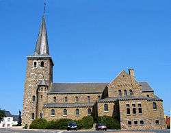
Verlaine
| Verlaine | |
|---|---|
| Municipality | |
 | |
 Verlaine Location in Belgium
Location of Verlaine in the province of Liège 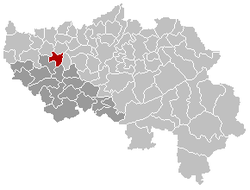 | |
| Coordinates: 50°36′N 05°19′E / 50.600°N 5.317°ECoordinates: 50°36′N 05°19′E / 50.600°N 5.317°E | |
| Country | Belgium |
| Community | French Community |
| Region | Wallonia |
| Province | Liège |
| Arrondissement | Huy |
| Government | |
| • Mayor | Hubert Jonet (IC) |
| • Governing party/ies | IC |
| Area | |
| • Total | 24.21 km2 (9.35 sq mi) |
| Population (1 January 2017)[1] | |
| • Total | 4,155 |
| • Density | 170/km2 (440/sq mi) |
| Postal codes | 4537 |
| Area codes | 04 |
| Website | www.verlaine.be |
Verlaine is a municipality of Belgium. It lies in the country's Walloon Region and Province of Liege. On January 1, 2006, Verlaine had a total population of 3,507. The total area is 24.21 km² which gives a population density of 145 inhabitants per km².
The municipality contains the villages of Verlaine, Chapon-Seraing, Seraing-le-Château and Bodegnée.
See also
References
- ↑ Population per municipality as of 1 January 2017 (XLS; 397 KB)
External links

Places adjacent to Verlaine | |
|---|---|
Municipalities of the Province of Liège | ||
|---|---|---|
| Huy | 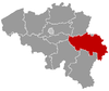 | |
| Liège | ||
| Verviers | ||
| Waremme | ||
This article is issued from
Wikipedia.
The text is licensed under Creative Commons - Attribution - Sharealike.
Additional terms may apply for the media files.