Theux
| Theux | |||
|---|---|---|---|
| Municipality | |||
.JPG) Place du Perron | |||
| |||
 Theux Location in Belgium
Location of Theux in the province of Liège  | |||
| Coordinates: 50°32′N 05°49′E / 50.533°N 5.817°ECoordinates: 50°32′N 05°49′E / 50.533°N 5.817°E | |||
| Country | Belgium | ||
| Community | French Community | ||
| Region | Wallonia | ||
| Province | Liège | ||
| Arrondissement | Verviers | ||
| Government | |||
| • Mayor | Philippe Boury | ||
| Area | |||
| • Total | 83.36 km2 (32.19 sq mi) | ||
| Population (1 January 2017)[1] | |||
| • Total | 12,080 | ||
| • Density | 140/km2 (380/sq mi) | ||
| Postal codes | 4910 | ||
| Area codes | 087 | ||
| Website | www.theux.be | ||


Theux is a Walloon municipality of Belgium in Province of Liège. On 1 January 2006 the municipality had 11,571 inhabitants. The total area is 83.36 km², giving a population density of 139 inhabitants per km².
The municipality consists of the following sub-municipalities: Theux proper, La Reid, and Polleur.
History
In World War II, the 75th Division of the U.S. Army, 575th Signal Co., maintained its command post in the town from January 10–12, 1945, as it counterattacked against the German army in the Battle of the Bulge.
Notable buildings
- Franchimont Castle is located in Theux municipality.
- A Perron, symbol of the town's status.
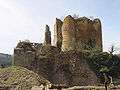 Franchimont Castle
 Theux Perron
.JPG) Town Hall of Theux
Town Hall of Theux
See also
References
- ↑ Population per municipality as of 1 January 2017 (XLS; 397 KB)
External links

Municipalities of the Province of Liège | ||
|---|---|---|
| Huy | 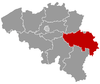 | |
| Liège | ||
| Verviers | ||
| Waremme | ||
This article is issued from
Wikipedia.
The text is licensed under Creative Commons - Attribution - Sharealike.
Additional terms may apply for the media files.