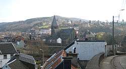
Pepinster
| Pepinster | |
|---|---|
| Municipality | |
 | |
 Pepinster Location in Belgium
Location of Pepinster in the province of Liège 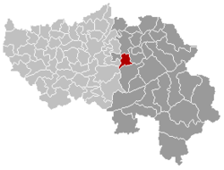 | |
| Coordinates: 50°34′N 05°49′E / 50.567°N 5.817°ECoordinates: 50°34′N 05°49′E / 50.567°N 5.817°E | |
| Country | Belgium |
| Community | French Community |
| Region | Wallonia |
| Province | Liège |
| Arrondissement | Verviers |
| Government | |
| • Mayor | Philippe Godin |
| Area | |
| • Total | 24.79 km2 (9.57 sq mi) |
| Population (1 January 2017)[1] | |
| • Total | 9,807 |
| • Density | 400/km2 (1,000/sq mi) |
| Postal codes | 4860-4861 |
| Area codes | 087 |
| Website | www.pepinster.be |
Pepinster is a Walloon municipality of Belgium in Province of Liège. On 1 January 2006 Pepinster had a total population of 9,560. The total area is 24.79 km² which gives a population density of 386 inhabitants per km². Pepinster is situated at the confluence of the rivers Hoëgne and Vesdre.
The municipality consists of the following sub-municipalities: Pepinster proper, Cornesse, Soiron, and Wegnez.
Image gallery
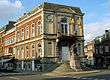 Pepinster town hall
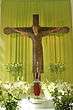 The romanesque Christ (11th century).
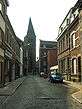
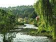 the Vesdre river
See also
- Fort de Tancrémont, a companion to Fort Eben-Emael, located just outside the town
- List of protected heritage sites in Pepinster
References
- ↑ Population per municipality as of 1 January 2017 (XLS; 397 KB)
External links

Municipalities of the Province of Liège | ||
|---|---|---|
| Huy | 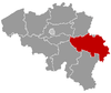 | |
| Liège | ||
| Verviers | ||
| Waremme | ||
This article is issued from
Wikipedia.
The text is licensed under Creative Commons - Attribution - Sharealike.
Additional terms may apply for the media files.