Aywaille
| Aywaille | ||
|---|---|---|
| Municipality | ||
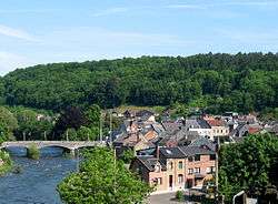 The Amblève in Aywaille | ||
| ||
 Aywaille Location in Belgium
Location of Aywaille in Liège province  | ||
| Coordinates: 50°28′N 05°40′E / 50.467°N 5.667°ECoordinates: 50°28′N 05°40′E / 50.467°N 5.667°E | ||
| Country | Belgium | |
| Community | French Community | |
| Region | Wallonia | |
| Province | Liège | |
| Arrondissement | Liège | |
| Government | ||
| • Mayor | Philippe Dodrimont | |
| • Governing party/ies | EC | |
| Area | ||
| • Total | 79.97 km2 (30.88 sq mi) | |
| Population (1 January 2017)[1] | ||
| • Total | 12,277 | |
| • Density | 150/km2 (400/sq mi) | |
| Postal codes | 4920 | |
| Area codes | 04 | |
| Website | www.aywaille.be | |
Aywaille is a Belgian municipality located in the Walloon province of Liège. On 1 January 2012, Aywaille had a total population of 11,697. The total area is 80.04 km² which gives a population density of 146 inhabitants per km².[2] Its area consists of 45.7% of wooded and wild country, 29.9% of agricultural areas and 24.4% of built-up areas.[3]
The inhabitants of Aywaille are called the "Aqualiens", from the Latin version of Aywaille "Aqualia loca", which means "area full of water" or "muddy land".[3]
The municipality includes not only the entity of Aywaille itself but also the entities of Ernonheid, Harzé, and Sougné-Remouchamps. They include many villages as Aywaille, Awan, Chambralles, Deigné, Ernonheid, Paradis, Houssonloge, Pouhon, Harzé, Havelange, Kin, Stoqueu, Martinrive, Nonceveux, Playe, Quarreux, Sedoz, Septroux, Sougné, Remouchamps, Ville-au-Bois.[3]
See also
References
- ↑ Population per municipality as of 1 January 2017 (XLS; 397 KB)
- ↑ "Commune d'Aywaille: coordonnées, bourgmestre, coalition, population et superficie". www.uvcw.be. Retrieved 2015-11-03.
- 1 2 3 "Commune d'Aywaille ..." www.aywaille.be. Retrieved 2015-11-03.
External links

Municipalities of the Province of Liège | ||
|---|---|---|
| Huy | 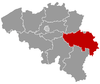 | |
| Liège | ||
| Verviers | ||
| Waremme | ||