Fléron
| Fléron | ||
|---|---|---|
| Municipality | ||
 | ||
| ||
 Fléron Location in Belgium
Location of Fléron in Liège province  | ||
| Coordinates: 50°37′N 05°41′E / 50.617°N 5.683°ECoordinates: 50°37′N 05°41′E / 50.617°N 5.683°E | ||
| Country | Belgium | |
| Community | French Community | |
| Region | Wallonia | |
| Province | Liège | |
| Arrondissement | Liège | |
| Government | ||
| • Mayor | Roger Lespagnard (IC) | |
| • Governing party/ies | IC, Ecolo | |
| Area | ||
| • Total | 13.72 km2 (5.30 sq mi) | |
| Population (1 January 2017)[1] | ||
| • Total | 16,467 | |
| • Density | 1,200/km2 (3,100/sq mi) | |
| Postal codes | 4620-4624 | |
| Area codes | 04 | |
| Website | www.fleron.be | |
Fléron is a Walloon municipality located in the Belgian province of Liège. On January 1, 2006, Fléron had a total population of 16,088. The total area is 13.72 km2 (5 sq mi) which gives a population density of 1,172 inhabitants per km². Fléron is west of the city of Liège.
The municipality of Fléron consists of the village of Fléron and the villages (also subdivisions) of Retinne, Magnée and Romsée.
The reminders of Fort de Fléron are in the center of the village of Fléron.
Image gallery
 Fléron town hall
 Fléron St. Denis
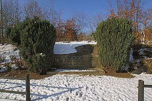 Fort de Fléron
 Retinne
See also
References
- ↑ Population per municipality as of 1 January 2017 (XLS; 397 KB)
External links

Places adjacent to Fléron | ||||||||||
|---|---|---|---|---|---|---|---|---|---|---|
| ||||||||||
Municipalities of the Province of Liège | ||
|---|---|---|
| Huy | 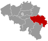 | |
| Liège | ||
| Verviers | ||
| Waremme | ||
This article is issued from
Wikipedia.
The text is licensed under Creative Commons - Attribution - Sharealike.
Additional terms may apply for the media files.