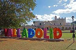
Valladolid, Yucatán
| Valladolid | ||
|---|---|---|
| City | ||
 | ||
| ||
|
Nickname(s): La Sultana del Oriente (The Sultan of the East) | ||
|
Motto(s): Cuatro Veces Heróica (Four Times Heroic) | ||
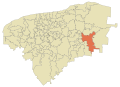
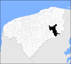 Location of Valladolid within State of Yucatan | ||
|
Valladolid Location of Valladolid within Mexico | ||
| Coordinates: 20°41′22″N 88°12′06″W / 20.68944°N 88.20167°WCoordinates: 20°41′22″N 88°12′06″W / 20.68944°N 88.20167°W | ||
| Country | Mexico | |
| State | Yucatán | |
| Municipality | Valladolid | |
| City Founded | May 28, 1543[1] | |
| Founded by | Francisco de Montejo (the Nephew) | |
| IDH |
| |
| Government | ||
| • Municipal president |
| |
| Area | ||
| • Total | 431.4 sq mi (1,117 km2) | |
| Elevation | 30 ft (9 m) | |
| Population (2010)[3] | ||
| • Total | 48,973 | |
| • Density | 110/sq mi (44/km2) | |
| Demonym(s) | Vallisoletano(a) | |
| Time zone | UTC-6 (Central Standard Time) | |
| • Summer (DST) | UTC-5 (Central Daylight Time) | |
| ZIP | 97780 | |
| Calling Code | 985 | |
| Climate | Aw | |

Valladolid (Saki' in Maya) (Spanish ![]()
As of the 2010 census the population of the city was 45,868 inhabitants (the third-largest community in the state), and that of the municipality was 74,217. The municipality has an areal extent of 945.22 km² (364.95 sq mi) and includes many outlying communities, the largest of which are Popolá, Kanxoc, Yalcobá, and Xocén. Valladolid is located approximately 160 km east of the state capital Mérida, 40 km east of Chichen Itza, and 150 km west of Cancun.
On August 30, 2012, Valladolid became part of the Pueblo Mágico promotional initiative led by the Mexican tourism department.
History
Named after Valladolid, at the time the capital of Spain. The name derives from the Arabic expression Ballad Al-Walid بلد الوليد, which means "city of Al-Walid", referring to Al-Walid I. the first Valladolid in Yucatán was established by Spanish Conquistador Francisco de Montejo's nephew on May 27, 1543 at some distance from the current town, at a lagoon called Chouac-Ha in the municipality of Tizimin. However, early Spanish settlers complained about the mosquitos and humidity at the original location, and petitioned to have the city moved further inland.
On March 24, 1545, Valladolid was relocated to its current location, built atop a Maya town called Zaci or Zaci-Val, whose buildings were dismantled to reuse the stones to build the Spanish colonial town. The following year the Maya people revolted, but were put down with additional Spanish troops coming from Mérida.
Valladolid had a population of 15,000 in 1840. In January 1847, the native Mayans rioted, killing some eighty whites and sacking their houses. After a Mayan noble was shot by firing squad, the riot became a general uprising. It was led by Jacinto Pat, batab of Tihosuco and by Cecilio Chi of nearby Ichmul.[4] The city and the surrounding region was the scene of intense battle during Yucatán's Caste War, and the Ladino forces were forced to abandon Valladolid on March 14, 1848, with half being killed by ambush before they reached Mérida. The city was sacked by the Maya rebels but was recaptured later in the war.
Until the beginning of the 20th century, Valladolid was the third largest and most important city of the Yucatán Peninsula, (after Mérida and Campeche). It had a sizable well-to-do Criollo population, with a number of old Spanish style mansions in the old city. Valladolid was widely known by its nickname The Sultana of the East.
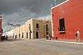
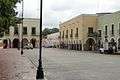
Sights
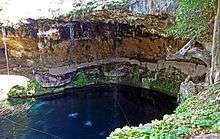
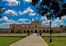
Valladolid is a popular city in which to explore the history and culture of the Yucatan peninsula. From colonial era churches and architecture to natural attractions like cenote, notable sights include the colonial era cathedral Ex-convent and church Convent of San Bernardino de Siena named after saint Bernardino of siena which was built by Franciscan missionaries between 1552 and 1560 in the Sisal neighbourhood. In downtown Valladolid is the cathedral of San Servacio located in the main square of the city. The center of the city's grid-like road structure features a plaza surrounded by restaurants and shops. Located close to the heart of the city is the Cenote Zaci, a landscaped freshwater cenote or underground sinkhole in which visitors can explore and swim. There is also a restaurant in the premises of the Cenote Zaci and artisans selling handcrafts. Valladolid is a popular base for visiting nearby major Mayan ruins such as Chichen Itza and Ek' Balam, as well as Cenote Ik Kil. Many principal sites are marked with bilingual signage to make them more hospitable for English-speaking tourists.
Places of interest
Downtown Valladolid
- Cathedral of "San Servacio o Gervasio"
- Main center park "Francisco Cantón Rosado"
- Municipal Palace (Palacio Municipal)
- Cenote Zaci
- House of the Culture (Casa de la Cultura)
- House of the Deer (Casa de los Venados)
- Mercado de Artesanías (Handcraft Market)
- Centro Artesanal Zaci (Handcraft center Zaci)
- Bazar Municipal
- Museo San Roque
- Parque de los Héroes (Park of the Heroes)
- Las 5 Calles
Sisal Neighbourhood
- Temple and former Convent de "San Bernandino de Siena"
- "Calzada de los Frailes"
- Park of Sisal (parque de Sisal)
Candelaria Neighbourhood
- Church of "Nuestra Señora de la Candelaria"
- Park of "Nuestra Señora de la Candelaria"
- Ex Telar “La Aurora”
- Municipal Market (Mercado Municipal) “Donato Bates Herrera”
Santa Lucia Neighbourhood
- Church de "Santa Lucía"
- Park de Santa Lucía
San Juan Neighbourhood
- Church de San Juan de Dios
- Park de San Juan de Dios
Other locations
Gastronomy
The typical dish of the region is “Lomitos de Valladolid” which is a pork dish in fresh tomato sauce; Cochinita pibil meat marinated in achiote, which comes from the Bixa orellana bitter orange, and spices, wrapped in Banana leaf and barbecued or baked in a pit; "lechon al horno", "bistek de cazuela", "relleno negro" which is turkey cooked with a paste of charred chillies and vegetables with bits of hard-boiled eggs, "frijol con puerco" and chicken in escabeche. Valladolid is also known for its Longaniza which are a type of pork based salami sausage with traditional condiments. Local traditional candies are based on materials from the region such as honey, coconut, corn and others. Traditional ice cream is very popular and a must have on your visit. The most common flavours are coconut, corn and fruits of the region as "guanabana" or Soursop, "mamey" or Pouteria sapota Sapote and others.
Climate
The climate in the Yucatan peninsula is hot and dry. There is also tropical rain with hot and predominate trade winds most times of the year. Valladolid features a tropical wet and dry climate. The city lies in the trade wind belt close to the Tropic of Cancer, with the prevailing wind from the east. Valladolid's climate is hot and humidity is moderate to high, depending on the time of year. The average annual high temperature is 33 °C (91 °F), ranging from 28 °C (82 °F) in January to 36 °C (97 °F) in May, but temperatures often rise above 38 °C (100 °F) in the afternoon in this time. Low temperatures range between 18 °C (64 °F) in January to 23 °C (73 °F) in May and June. It is most often a few degrees hotter in Valladolid than coastal areas due to its inland location and low elevation. The rainy season runs from June through October, associated with the Mexican monsoon which draws warm, moist air landward. Easterly waves and tropical storms also affect the area during this season.
| Climate data for Valladolid, Yucatán (1981–2000) | |||||||||||||
|---|---|---|---|---|---|---|---|---|---|---|---|---|---|
| Month | Jan | Feb | Mar | Apr | May | Jun | Jul | Aug | Sep | Oct | Nov | Dec | Year |
| Record high °C (°F) | 36.3 (97.3) |
36.6 (97.9) |
40.5 (104.9) |
41.6 (106.9) |
42.8 (109) |
40.4 (104.7) |
39.6 (103.3) |
39.5 (103.1) |
38.5 (101.3) |
38.5 (101.3) |
37.5 (99.5) |
34.6 (94.3) |
42.8 (109) |
| Average high °C (°F) | 29.8 (85.6) |
31.3 (88.3) |
33.0 (91.4) |
35.2 (95.4) |
36.2 (97.2) |
34.5 (94.1) |
34.6 (94.3) |
34.6 (94.3) |
33.9 (93) |
32.4 (90.3) |
31.1 (88) |
29.9 (85.8) |
33.0 (91.4) |
| Daily mean °C (°F) | 23.5 (74.3) |
24.4 (75.9) |
25.7 (78.3) |
27.9 (82.2) |
29.1 (84.4) |
28.8 (83.8) |
28.4 (83.1) |
28.4 (83.1) |
28.1 (82.6) |
26.8 (80.2) |
25.0 (77) |
23.8 (74.8) |
26.6 (79.9) |
| Average low °C (°F) | 17.1 (62.8) |
17.5 (63.5) |
18.5 (65.3) |
20.6 (69.1) |
22.1 (71.8) |
23.1 (73.6) |
22.2 (72) |
22.2 (72) |
22.2 (72) |
21.2 (70.2) |
18.9 (66) |
17.6 (63.7) |
20.3 (68.5) |
| Record low °C (°F) | 7.6 (45.7) |
8.4 (47.1) |
8.1 (46.6) |
10.7 (51.3) |
13.4 (56.1) |
19.3 (66.7) |
19.4 (66.9) |
19.4 (66.9) |
19.4 (66.9) |
15.2 (59.4) |
11.2 (52.2) |
9.1 (48.4) |
7.6 (45.7) |
| Average precipitation mm (inches) | 39.0 (1.535) |
56.8 (2.236) |
59.1 (2.327) |
33.8 (1.331) |
74.6 (2.937) |
172.0 (6.772) |
141.9 (5.587) |
141.5 (5.571) |
176.8 (6.961) |
145.9 (5.744) |
46.4 (1.827) |
53.5 (2.106) |
1,141.2 (44.929) |
| Average precipitation days (≥ 0.1 mm) | 6.1 | 4.2 | 3.0 | 3.1 | 7.3 | 12.9 | 15.5 | 17.1 | 18.4 | 14.6 | 5.9 | 5.8 | 113.8 |
| Average relative humidity (%) | 75 | 71 | 69 | 68 | 68 | 75 | 75 | 76 | 78 | 79 | 77 | 76 | 74 |
| Mean monthly sunshine hours | 224 | 242 | 272 | 259 | 251 | 229 | 223 | 223 | 203 | 233 | 209 | 210 | 2,778 |
| Source #1: Servicio Meteorológico National[5] | |||||||||||||
| Source #2: Deutscher Wetterdienst (sun, 1961–1990)[6][lower-alpha 1] | |||||||||||||
Transportation
Valladolid has a structured road service which makes it easy to travel around. Travellers driving through the peninsula have the option of taking the federal road or the toll route and both roads go through Valladolid. In the city there are taxi services at reasonable rates and public transportation which is popular for students and locals but not recommended for tourists. There is an Autobuses de Oriente bus terminal situated in the heart of the city which serves to the travellers going to all mayor cities in the Yucatan peninsula, such as Mérida, Cancun, Playa del Carmen and Tulum as well as archeological sites such as Chichen Itza Coba and Ek' Balam
Sister cities
The city of Valladolid has maintained a sister city relationship with Asheville, North Carolina since 2006.[7]
Gallery

References
- ↑ Casares G. Cantón, Raúl; Duch Colell, Juan; Antochiw Kolpa, Michel; Zavala Vallado, Silvio et ál. Yucatán en el tiempo, 1998 ISBN 970 9071 04 1, Mérida, Yucatán, Mexico
- ↑ "Indicadores de Desarrollo Humano y Género en México 2000-2005" (PDF). Programa de las Naciones Unidas para el Desarrollo. Archived from the original (PDF) on 22 July 2011. Retrieved 16 August 2010.
- ↑ Instituto Nacional de Estadística y Geografía (2005). "Principales resultados por localidad (ITER)". Archived from the original on 2011-07-22.
- ↑ Ronald Wright, 'Stolen Continents, Conquest and resistance in the Americas.' 257
- ↑ "NORMALES CLIMATOLÓGICAS 1981–2000" (PDF) (in Spanish). Servicio Meteorológico Nacional. Archived from the original (PDF) on 15 February 2015. Retrieved 6 May 2015.
- ↑ "Station 76647 Valladolid, YUC". Global station data 1961–1990—Sunshine Duration. Deutscher Wetterdienst. Retrieved 6 May 2015.
- ↑ "Interactive City Directory: Valladolid, Mexico". Sister Cities International. Retrieved July 23, 2016.
- Link to tables of population data from Census of 2005 INEGI: Instituto Nacional de Estadística, Geografía e Informática
- Yucatán Enciclopedia de los Municipios de México
Notes
- ↑ Station ID for Valladolid, YUC. is 76647 Use this station ID to locate the sunshine duration
External links
| Wikivoyage has a travel guide for Valladolid (Yucatan). |

- Valladolid Photo Essay
| Urban areas |
|  |
|---|---|---|
| Demography |
| |
Mérida (capital) | |||||||||||||||
| Topics | 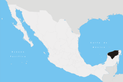 | ||||||||||||||
| Metros | |||||||||||||||
| Larger cities | |||||||||||||||
| Smaller cities |
| ||||||||||||||
| Municipalities |
| ||||||||||||||
| Authority control |
|---|