Chocholá Municipality
| Chocholá | |
|---|---|
| Municipality | |
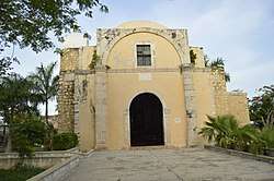 Principal Church of Celestún, Yucatán | |
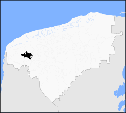 Location of Chochola in Yucatan | |
|
Chocholá Location of the municipality in Mexico | |
| Coordinates: 20°45′03″N 89°49′47″W / 20.7508°N 89.8297°WCoordinates: 20°45′03″N 89°49′47″W / 20.7508°N 89.8297°W | |
| Country | Mexico |
| State | Yucatán |
| Government | |
| • Municipal President | Erwin Obet Martin Alcocer |
| Area[1] | |
| • Total | 99.64 km2 (38.47 sq mi) |
| Population (2010)[1] | |
| • Total | 4,530 |
| • Density | 45/km2 (120/sq mi) |
| Time zone | UTC-6 (Central Standard Time) |
| • Summer (DST) | UTC-5 (Central Daylight Time) |
| INEGI Code | 31011 |
| Municipalities of Yucatán | |
Chocholá Municipality is one of 106 municipalities in the Mexican state of Yucatan. It is located in the western part of the state, about 21 kilometers southwest of the city of Merida. The name is said to mean "brackish water".
- Area: 99. 64 km2.
- Population: 4,339[2]
- Women: 2,135
- Men: 2,205
- Average elevation: 14 meters
Geography
The municipality is bordered on the south by Kopomá, and on the west by Samahil and Maxcanú. To the north and east lies Umán and Samahil also shares a part of the northern boundary.
Water and land
The terrain is flat and rocky. Primary use is for grazing, agriculture and forestry. Water sources are underground and include six cenotes. The climate is sub-humid with rain falling primarily between the months of May and July. The average rainfall is 1200 mm. The average annual temperature is 26.8 °C.
Communities
The primary population centre is the eponymous Chocholá. Among the other communities of the municipality are Pujil, Chablé, San Francisco, Juat, San Matías, Cheneld, and San Pablo.[1]
Points of interest
- The former Chocholá hacienda
- Temple of the Immaculate Conception
- Mayan sites
Events and festivities
- Mexican Independence Day: Sept. 16
- Day of the Mexican Revolution: Nov. 20
- Easter: Thursday and Friday before
- Holy Cross Day, May 3
- Virgin of Guadalupe celebration: Dec. 12
- Day of the Dead: Nov. 2
- Celebration in honor of Christ's Love: Sept. 24-30
Government
Elections are held every three years, when the mayor and his cabinet are chosen. There are fifteen localities in the municipality; the most important are: Chocholá (cabecera municipal), San Antonio Chablé, El Roble, Tch'een-Men, El Limonar, Doroteo Arango, Misko, San Luis Dos, Santa María, Xamán Ek and San Luis Cuatro.
References
- 1 2 3 "Municipios de Yucatán »Chocholá" (in Spanish). Retrieved 16 February 2018.
- ↑ "Preliminary results of the census of 2010. Yucatán" (PDF). INEGI. Retrieved 26 November 2010.
External links
| Wikimedia Commons has media related to Chocholá Municipality. |
- Chocholá, Yucatán in the Enciclopedia de los Municipios y Delegaciones de México.
- Prontuario de Información Geográfica Municipal - Geographical information on the municipality published by INEGI. (in Spanish)
Mérida (capital) | |||||||||||||||
| Topics | 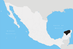 | ||||||||||||||
| Metros | |||||||||||||||
| Larger cities | |||||||||||||||
| Smaller cities |
| ||||||||||||||
| Municipalities |
| ||||||||||||||