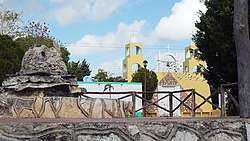
Chankom Municipality
| Chankom | |
|---|---|
| Municipality | |
 | |
 Region 6 Oriente #017 | |
|
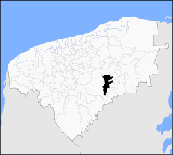
Chankom Location of the municipality in Mexico | |
| Coordinates: 20°34′05″N 88°30′48″W / 20.56806°N 88.51333°WCoordinates: 20°34′05″N 88°30′48″W / 20.56806°N 88.51333°W | |
| Country | Mexico |
| State | Yucatán |
| Government | |
| • Type |
|
| • Municipal President | Benjamín Cime Ek[2] |
| Area | |
| • Total | 137.95 km2 (53.26 sq mi) |
| [2] | |
| Elevation[2] | 27 m (89 ft) |
| Population (2010[3]) | |
| • Total | 4,464 |
| Time zone | UTC-6 (Central Standard Time) |
| • Summer (DST) | UTC-5 (Central Daylight Time) |
| INEGI Code | 009 |
| Major Airport | Merida (Manuel Crescencio Rejón) International Airport |
| IATA Code | MID |
| ICAO Code | MMMD |
| Website | Official Website |
Chankom Municipality (in the Yucatec Maya language: “little ravine”) is one of the 106 municipalities in the Mexican state of Yucatán containing (137.95 km2) of land and located roughly 135 km southeast of the city of Mérida.[2]
History
Before the arrival of the Spanish, the area was populated as evidenced by archeological sites but no specific information is known of the inhabitants nor the encomienda system. The area was depopulated by the Caste War of Yucatán and the inhabitants did not return to the area until the 1890s.[2]
Chankom was established as a ranchería assigned to the Valladolid region in 1928. Seven years later, it was designated as its own municipality.[2]
Governance
The municipal president is elected for a three-year term. The town council has four councilpersons, who serve as Secretary and councilors of policing, public services and ecology.[4]
Communities
The head of the municipality is Chankom, Yucatán. There are 17 populated places in the municipality including Chuntabil, Maykab, Muchucuxca, Nictehá, Sacpasil, San Isidro, San Juan, Santa María Koochilá, Santa Rosa, Ticimul, Tomku, Tzukmuc, Xanla, Xbohon, Xcalakdzonot, X-Cocail, Xhuaymil, Xkatún, Xkopeteil, X-Pamba, Xtamech, Xtohil, Yacbchem, and Yochotún.[4][2] The significant populations are shown below:
| Community | Population |
|---|---|
| Entire Municipality (2010) | 4,464[3] |
| Chankom | 628 in 2005[5] |
| Muchucuxcáh | 314 in 2005[6] |
| Ticimul | 642 in 2005[7] |
| Tzukmuc | 212 in 2005[8] |
| Xanlá | 406 in 2005[9] |
| X-Bohom | 108 in 2005[10] |
| X-Cocail | 161 in 2005[11] |
| Xkalakdzonot | 770 in 2005[12] |
| Xkatún | 130 in 2005[13] |
| Xkopteil | 754 in 2005[14] |
Local festivals
Every year from the 9 to 13 November the town holds a celebration for its patron saint, San Diego.[2]
Tourist attractions
- Cenote Chankom
- Cenote Kochila
- Cenote Muchucuxca
- Cenote Nicte-Ha
- Cenote Santa María
- Archaeological site Cosil
- Archaeological site Cosil
- Archaeological site Kochilá
- Archaeological site Ticimul
- Archaeological site Xcocail
References
- ↑ "Presidentes Municipales" (in Spanish). Mérida, Mexico: PRI yucatan. 23 January 2014. Retrieved 8 July 2015.
- 1 2 3 4 5 6 7 8 "Municipios de Yucatán »Chankom" (in Spanish). Retrieved 8 July 2015.
- 1 2 "Mexico In Figures:Chankom, Yucatán". INEGI (in Spanish and English). Aguascalientes, México: Instituto Nacional de Estadística y Geografía (INEGI). Archived from the original on 6 May 2015. Retrieved 4 July 2015.
- 1 2 "Chankom". inafed (in Spanish). Mérida, Mexico: Enciclopedia de Los Municipios y Delegaciones de México. Retrieved 8 July 2015.
- ↑ "Chankom". PueblosAmerica (in Spanish). PueblosAmerica. 2005. Retrieved 8 July 2015.
- ↑ "Muchucuxcáh". PueblosAmerica (in Spanish). PueblosAmerica. 2005. Retrieved 8 July 2015.
- ↑ "Ticimul". PueblosAmerica (in Spanish). PueblosAmerica. 2005. Retrieved 8 July 2015.
- ↑ "Tzukmuc". PueblosAmerica (in Spanish). PueblosAmerica. 2005. Retrieved 8 July 2015.
- ↑ "Xanlá". PueblosAmerica (in Spanish). PueblosAmerica. 2005. Retrieved 8 July 2015.
- ↑ "X-Bohom". PueblosAmerica (in Spanish). PueblosAmerica. 2005. Retrieved 8 July 2015.
- ↑ "X-Cocail". PueblosAmerica (in Spanish). PueblosAmerica. 2005. Retrieved 8 July 2015.
- ↑ "Xkalakdzonot". PueblosAmerica (in Spanish). PueblosAmerica. 2005. Retrieved 8 July 2015.
- ↑ "Xkatún". PueblosAmerica (in Spanish). PueblosAmerica. 2005. Retrieved 8 July 2015.
- ↑ "Xkopteil". PueblosAmerica (in Spanish). PueblosAmerica. 2005. Retrieved 8 July 2015.
| Wikimedia Commons has media related to Chankom Municipality. |
Mérida (capital) | |||||||||||||||
| Topics | 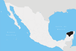 | ||||||||||||||
| Metros | |||||||||||||||
| Larger cities | |||||||||||||||
| Smaller cities |
| ||||||||||||||
| Municipalities |
| ||||||||||||||