Temozón Municipality
| Temozón | |
|---|---|
| Municipality | |
 | |
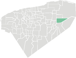 Location of the Municipality | |
|
Temozón Location of the Municipality in Mexico | |
| Coordinates: 20°55′N 87°55′W / 20.917°N 87.917°WCoordinates: 20°55′N 87°55′W / 20.917°N 87.917°W | |
| Country |
|
| State |
|
| Mexico Ind. | 1821 |
| Yucatan Est. | 1824 |
| Municipality Est. | 1915[1] |
| Government | |
| • Type |
PRI |
| • Municipal President | Carlos Manuel Aguilar Loria[1] |
| Area | |
| • Total | 1,087.06 km2 (419.72 sq mi) |
| [1] | |
| Elevation[1] | 22 m (72 ft) |
| Population (2005 [2][3]) | |
| • Total | 14,008 |
| • Demonym | Temozonense |
| Time zone | UTC-6 (Central Standard Time) |
| • Summer (DST) | UTC-5 (Central Daylight Time) |
| INEGI Code | 085 |
| Major Airport | Merida (Manuel Crescencio Rejón) International Airport |
| IATA Code | MID |
| ICAO Code | MMMD |
| Website | Official Website |
Temozón Municipality is one of the 106 subdivisions of the State of Yucatán in Mexico. Its municipal seat is located in the City of Temozón.
Location
This municipality is located in the eastern region of the state. It is between latitudes 20° 48 'and 20° 57' north and longitudes 87° 47' and 88 ° 16' west.[1]
Its northern border is Calotmul - Tizimín, to the south is Valladolid, on the east Chemax and the west Espita and Uayma.[1]
Communities
The municipality is made up of 99 different communities, of which the most important are:[1]
- Temozón (Municipal Center)
- Hunuku
- Nahbalam
- Yokdzonot Presentado
- Santa Rita
Landmarks
Architectural
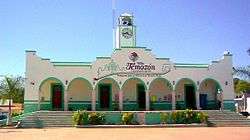
San Roman Church, built during the colonial period (probably in the eighteenth century). The church of San Antonio de Padua, and the municipal building.[1]
Archeological
References
- 1 2 3 4 5 6 7 8 9 "Nuestros municipios - Temozón". Archived from the original on 2009-07-24. Retrieved 2009-11-11.
- ↑ "Encyclopedia of the Municipalities of Mexico: Yucatan". Archived from the original on 2008-11-20. Retrieved 2009-11-01.
- ↑ Census Results by Locality, 2005 Archived 2011-07-22 at the Wayback Machine. INEGI.
Mérida (capital) | |||||||||||||||
| Topics | 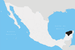 | ||||||||||||||
| Metros | |||||||||||||||
| Larger cities | |||||||||||||||
| Smaller cities |
| ||||||||||||||
| Municipalities |
| ||||||||||||||
This article is issued from
Wikipedia.
The text is licensed under Creative Commons - Attribution - Sharealike.
Additional terms may apply for the media files.