Espita Municipality
| Espita | ||
|---|---|---|
| Municipality | ||
| ||
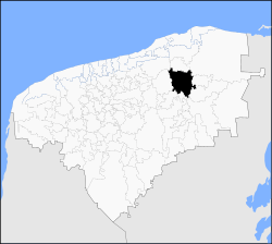 Location of the Municipality | ||
| Country |
| |
| State |
| |
| Mexico Ind. | 1821 | |
| Yucatan Est. | 1824 | |
| Municipality Est. | 1921[1] | |
| Government | ||
| • Municipal President |
José Luis Uc Moo (2010-2012)[2][3] ( | |
| Area | ||
| • Total | 496.91 km2 (191.86 sq mi) | |
| [1] | ||
| Elevation | 15 m (49 ft) | |
| Population (2005 [5][6]) | ||
| • Total | 14,432 | |
| • Demonym | espitan | |
| Time zone | UTC-6 (Central Standard Time) | |
| • Summer (DST) | UTC-5 (Central Daylight Time) | |
| Postal Code | 97730 | |
| Area code(s) | 986 | |
| INEGI Code | 31032 | |
| Website | Official Website | |

Espita Municipality is one of the 106 subdivisions of the State of Yucatán in Mexico.[7] Its municipal seat is located in the City of Espita and is located on the Litoral Oriente (East Coast) or Region 1 of the state.[8] In 2005 was the 77th municipality with the highest HDI in the state with 0.7320,[9] same as obtained Honduras in 2007.[10]
Location
This municipality is located in the eastern part of the state. It is located between latitudes 20° 53' and 21° 08' north and longitudes 88° 16' and 88° 27' west.[1]
It borders the following municipalities: to the north Sucilá to the south Tinum and Uayma, on the east Temozón and Calotmul and the west Dzitas - Cenotillo.[1]
Demography
Education
| Type | Students | Teachers | Schools |
|---|---|---|---|
| Preschool education | 807 | 33 | 12 |
| Primary education | 2 566 | 87 | 16 |
| Secondary education | 808 | 63 | 5 |
| High school | 396 | 25 | 1 |
| Total | 4 577 | 208 | 34 |
| Source: Secretaría de Educación de Yucatán.[11] | |||
Communities
The municipality is responsible Espita 17 commissariats and the municipal seat,[12] in 2005 only 7 of its 17 commissariats exceeded 200 inhabitants and the sum of its population was 3,605 which together with the municipal seat (10,758) the population was of 14,363, i.e. the 99.52% of the municipal population.
| Towns over 200 people and its distance from the municipal seat | ||||
| Code | Commissariat | Coordinates | Population | Distance |
|---|---|---|---|---|
| 310320002[13] | Holcá | 21°05′28″N 88°16′07″W / 21.09111°N 88.26861°W | 501 | 9,95 km |
| 310320003[14] | Kunché | 20°54′35″N 88°18′16″W / 20.90972°N 88.30444°W | 698 | 10,84 km |
| 310320004[15] | Nacuché | 20°55′22″N 88°17′45″W / 20.92278°N 88.29583°W | 1.130 | 9,36 km |
| 310320005[16] | San Pedro Chenchelá | 20°52′29″N 88°18′51″W / 20.87472°N 88.31417°W | 261 | 14,58 km |
| 310320007[17] | Tuzik | 21°06′44″N 88°28′18″W / 21.11222°N 88.47167°W | 384 | 20,91 km |
| 310320008[18] | X-Ualtez | 21°07′20″N 88°28′22″W / 21.12222°N 88.47278°W | 262 | 21,77 km |
| 310320009[19] | Xuilub | 20°55′00″N 88°25′12″W / 20.91667°N 88.42000°W | 369 | 15,72 km |
| Source: INEGI,[6] Archivo Histórico de Localidaes.[20] | ||||
Landmarks
Architectural
St. Joseph's Temple, built in the eighteenth century the former Franciscan convent at the beginning of the sixteenth century, and the Municipal Palace.[1]
Archaeological
The area called Pom.[1]
References
- 1 2 3 4 5 6 "Nuestros municipios - Espita". Retrieved 2009-11-11.
- ↑ PorEsto! (May 20, 2010). "Oficial el triunfo de José Luis Uc Moo". Yucatanalamano.com.
- ↑ IPEPAC. "Directorio de alcaldes electos" (PDF). Archived from the original (PDF) on September 16, 2011. Retrieved July 31, 2010.
- ↑ IPEPAC. "Alcaldías de Yucatán por partido político" (PDF). Retrieved July 31, 2010.
- ↑ "Encyclopedia of the Municipalities of Mexico: Yucatan". Archived from the original on 2008-11-20. Retrieved 2009-11-01.
- 1 2 INEGI (2005). "Census Results by Locality". Archived from the original on 2011-07-22.
- ↑ Instituto Nacional de Estadística y Geografía. "Aspectos geográficos de Yucatán. División Municipal" (in Spanish). Archived from the original on July 22, 2011. Retrieved August 17, 2010.
- ↑ Instituto Nacional para el Federalismo y el Desarrollo Municipal. "Regionalización de Yucatán" (in Spanish). Enciclopedia de los Municipios de México. Archived from the original on June 16, 2011. Retrieved May 10, 2010.
- ↑ United Nations Development Programme. "Indicadores de Desarrollo Humano y Género en México 2000-2005" (PDF) (in Spanish). Archived from the original (PDF) on July 22, 2011. Retrieved August 12, 2010.
- ↑ United Nations Development Programme. "2009 Human Development Report" (PDF). p. 182. Retrieved August 12, 2010.
- ↑ SEEY. "Concentrado estadístico por Municipio". Retrieved November 19, 2010.
- ↑ www.yucatan.gob.mx. "Información del municipio". Retrieved August 18, 2010.
- ↑ INEGI. "Archivo Histórico de Localidades. Holcá". Retrieved August 18, 2010.
- ↑ INEGI. "Archivo Histórico de Localidades. Kunché". Retrieved August 18, 2010.
- ↑ INEGI. "Archivo Histórico de Localidades. Nacuché". Retrieved August 18, 2010.
- ↑ INEGI. "Archivo Histórico de Localidades. San Pedro Chenchelá". Retrieved August 18, 2010.
- ↑ INEGI. "Archivo Histórico de Localidades. Tuzik". Retrieved August 18, 2010.
- ↑ INEGI. "Archivo Histórico de Localidades. X-Ualtez". Retrieved August 18, 2010.
- ↑ INEGI. "Archivo Histórico de Localidades. Xuilub". Retrieved August 18, 2010.
- ↑ INEGI. "Archivo Histórico de Localidades". Archived from the original on August 19, 2010. Retrieved August 18, 2010.
| Urban areas |  | |
|---|---|---|
| Rural areas |
| |
| Demography | ||
Mérida (capital) | |||||||||||||||
| Topics | 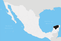 | ||||||||||||||
| Metros | |||||||||||||||
| Larger cities | |||||||||||||||
| Smaller cities |
| ||||||||||||||
| Municipalities |
| ||||||||||||||