Upper Mount Bethel Township, Northampton County, Pennsylvania
| Upper Mount Bethel Township | |
|---|---|
 Rolling hills | |
.svg.png) Location of Pennsylvania in the United States | |
| Coordinates: 40°52′00″N 75°07′59″W / 40.86667°N 75.13306°WCoordinates: 40°52′00″N 75°07′59″W / 40.86667°N 75.13306°W | |
| Country | United States |
| State | Pennsylvania |
| County | Northampton |
| Area[1] | |
| • Total | 43.99 sq mi (113.93 km2) |
| • Land | 42.32 sq mi (109.60 km2) |
| • Water | 1.67 sq mi (4.33 km2) |
| Elevation | 699 ft (213 m) |
| Population (2010) | |
| • Total | 6,706 |
| • Estimate (2016)[2] | 6,859 |
| • Density | 162.08/sq mi (62.58/km2) |
| Time zone | UTC-5 (EST) |
| • Summer (DST) | UTC-4 (EDT) |
| Area code(s) | 570, 610 |
| FIPS code | 42-095-79184 |
| Website |
www |
Upper Mount Bethel Township is a township in Northampton County, Pennsylvania, United States. Upper Mount Bethel Township is located in the Lehigh Valley region of the state. It is part of Pennsylvania's Slate Belt.[3]
The population of Upper Mount Bethel Township was 6,706 at the 2010 census.
Geography
According to the United States Census Bureau, the township has a total area of 44.3 square miles (115 km2). 43.4 square miles (112 km2) of it is land and 0.9 square miles (2.3 km2) of it (2.01%) is water. It is drained by the Delaware River, which forms its eastern boundary separating it from New Jersey. Its natural northwest boundary is Blue Mountain. Its villages include Centerville, Five Points, Hartzells Ferry, Johnsonville, Mount Bethel, North Bangor, and Slateford. Its numbered routes are 191, 512, and 611.
Neighboring municipalities
- Washington Township (southwest)
- East Bangor (southwest)
- Lower Mount Bethel Township (south)
- Belvidere, New Jersey (southeast)
- White Township, New Jersey (east)
- Knowlton Township, New Jersey (east)
- Portland (east)
- Delaware Water Gap, Monroe County (north)
- Stroud Township, Monroe County (north)
- Hamilton Township, Monroe County (northwest)
Demographics
| Historical population | |||
|---|---|---|---|
| Census | Pop. | %± | |
| 2000 | 6,063 | — | |
| 2010 | 6,706 | 10.6% | |
| Est. 2016 | 6,859 | [2] | 2.3% |
| U.S. Decennial Census[4] | |||
As of the census[5] of 2000, there were 6,063 people, 2,363 households, and 1,732 families residing in the township. The population density was 139.7 people per square mile (54.0/km2). There were 2,574 housing units at an average density of 59.3/sq mi (22.9/km2). The racial makeup of the township was 97.89% White, 0.69% African American, 0.13% Native American, 0.49% Asian, 0.21% from other races, and 0.58% from two or more races. Hispanic or Latino of any race were 1.39% of the population.
There were 2,363 households, out of which 28.8% had children under the age of 18 living with them, 63.4% were married couples living together, 6.1% had a female householder with no husband present, and 26.7% were non-families. 21.7% of all households were made up of individuals, and 8.9% had someone living alone who was 65 years of age or older. The average household size was 2.56 and the average family size was 2.96.
In the township the population was spread out, with 22.8% under the age of 18, 6.2% from 18 to 24, 28.3% from 25 to 44, 26.8% from 45 to 64, and 15.9% who were 65 years of age or older. The median age was 41 years. For every 100 females, there were 100.8 males. For every 100 females age 18 and over, there were 100.6 males.
The median income for a household in the township was $45,617, and the median income for a family was $54,692. Males had a median income of $38,914 versus $23,906 for females. The per capita income for the township was $21,116. About 4.6% of families and 6.3% of the population were below the poverty line, including 3.3% of those under age 18 and 15.7% of those age 65 or over.
Public education
The township is served by the Bangor Area School District and is the home to Bangor Area High School.
References
- ↑ "2016 U.S. Gazetteer Files". United States Census Bureau. Retrieved Aug 14, 2017.
- 1 2 "Population and Housing Unit Estimates". Retrieved June 9, 2017.
- ↑ "About Slate Belt Chamber". Slate Belt Chamber of Commerce. Retrieved June 7, 2011.
- ↑ "Census of Population and Housing". Census.gov. Retrieved June 4, 2016.
- ↑ "American FactFinder". United States Census Bureau. Retrieved 2008-01-31.
External links
Municipalities and communities of Northampton County, Pennsylvania, United States | ||
|---|---|---|
| Cities | 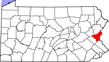 | |
| Boroughs | ||
| Townships | ||
| CDPs | ||
| Unincorporated communities | ||
| Footnotes | ‡This populated place also has portions in an adjacent county or counties | |