Upper Dir District
| Upper Dir District دیر بالا | |
|---|---|
| District | |
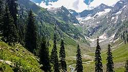 Jahaz Banda in Upper Dir’s Kumrat valley | |
| Country | Pakistan |
| Province | Khyber Pakhtunkhwa |
| Established | 1996 |
| Headquarters | Dir |
| Area | |
| • District | 3,699 km2 (1,428 sq mi) |
| Population (2017)[1] | |
| • District | 946,421 |
| • Density | 260/km2 (660/sq mi) |
| • Urban | 44,165 |
| • Rural | 902,256 |
| Time zone | UTC+5 (PST) |
| Number of Tehsils | 6 |
| Main language |
Pashto (majority) Gawri-Kohistani [2]:21 |
| Website | http://www.upperdir.pk/ |
Upper Dir (Pashto/Urdu: دیر بالا) is one of the 26[3] districts of Khyber Pakhtunkhwa, Pakistan. The town of Dir is the district headquarters.
At the time of independence, Dir was a princely state ruled by Nawab Shah Jehan Khan. It was merged with Pakistan in 1969 and later on declared as a district in 1970. In 1996, it was bifurcated into Upper and Lower Dir districts. This district is situated in the northern part of Pakistan. It borders Chitral district and Afghanistan on the north and north west and Swat district to the east, and on the south by Lower Dir District.[4]
History
The British Raj honored Muhammad sharif Khan as Nawab of Dir in 1898 . By declaring his allegiance to the British Raj, Khan/Nawab, once exiled to Afghanistan by Umara Khan Mastkhel was seated as Nawab of Dir. He was succeed by his son Nawab Aurang Zeb in 1904, who ruled until his death in 1925. His son Sir Shah Jehan succeeded him and ruled the state for 35 long years. He was dethroned and kept in house arrest in Lahore until his death in 1966 . He was succeeded by Mohammad Shah Khisro Khan. He left all the business at the mercy of his advisor, a man deputed by the Govt:of Pakistan to mould the state into a settled district through gradual implementation of laws. In 1969, it was merged as a district with Khyber Pakhtunkhwa. In 1996, Dir District was divided into two districts-Lower and Upper Dir- with Timergara and Dir as their respective headquarters.
Administration
The district of Upper Dir is divided into three tehsils:[5]
National Assembly
This district is represented by one elected MNA (Member of National Assembly) in Pakistan National Assembly. Its constituency is NA-33.[6]
| Member of National Assembly | Party Affiliation | Year |
|---|---|---|
| Molana Asad Ullah | Muttahida Majlis-e-Amal | 2002 |
| Najum-din Khan | Pakistan Peoples Party | 2008 |
| Sahibzada Tariq Ullah | Jamaat-e-Islami Pakistan | 2013 |
Provincial Assembly
The district is represented by three elected MPAs in the provincial assembly who represent the following constituencies:
Towns
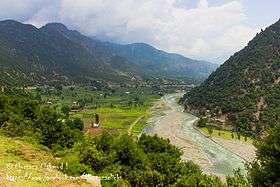
Except for Dir and a number of rapidly growing bazaar towns along the main roads, the population is rural, scattered in more than 1200 villages in the deep narrow valleys of the Panjkora and its tributaries.
Of these, notable villages are
Division of Dir
Dir district was officially split into Upper Dir and Lower Dir in 1996. Until 2000 as funds were not available to provide the accommodation needed at Dir town by government departments at a district headquarters, both districts continued to be administered by a single deputy Commissioner stationed at Timergara in Lower Dir.
Popular places[7]
See also
References
| Wikimedia Commons has media related to Upper Dir district. |
- ↑ "DISTRICT AND TEHSIL LEVEL POPULATION SUMMARY WITH REGION BREAKUP: KHYBER PAKHTUNKHWA" (PDF). Pakistan Bureau of Statistics. 2018-01-03. Retrieved 2018-04-23.
- ↑ 1998 District Census report of Upper Dir. Census publication. 104. Islamabad: Population Census Organization, Statistics Division, Government of Pakistan. 2000.
- ↑ Report, Bureau (16 January 2014). "KP govt creates new Kohistan district". dawn.com.
- ↑ http://paiman.jsi.com/Resources/Docs/district-health-profile-upperdir.pdf
- ↑ http://www.pbscensus.gov.pk/sites/default/files/admin_districts/KPK.pdf
- ↑ "Archived copy". Archived from the original on 2015-11-10. Retrieved 2015-11-06.
- ↑ http://www.pdma.gov.pk/documents/District_Tehsil_and_Union_code_Reference_Map_Upper_Dir.pdf%5Bpermanent+dead+link%5D
Provincial capital: Peshawar | ||
| Divisions | Districts | 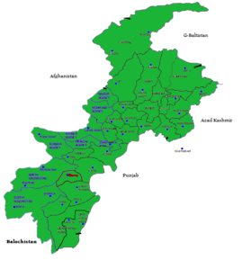 |
| Bannu | ||
| Dera Ismail Khan | ||
| Hazara | ||
| Kohat | ||
| Malakand | ||
| Mardan | ||
| Peshawar | ||
Administrative divisions of Upper Dir District | ||
|---|---|---|
| Capital | ||
| Tehsils | ||
| Union councils | ||
Coordinates: 35°12′15″N 71°52′20″E / 35.20417°N 71.87222°E