Shalkani
Shalkani | |
|---|---|
 | |
| Country | Pakistan |
| Province | Pukhtunkhwa |
| Union Council | Shalpalam |
| Houses | 450 |
| Language | Pashto (100%) |
| Religion | Islam (100%) |
| Area | |
| • Total | 6 km2 (2 sq mi) |
| Population (1998) | |
| • Total | 3,000 |
| Time zone | PST |
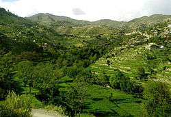
The Shalkani (Urdu: شلکنی) is a village in northern Khyber Pakhtunkhwa, northwestern Pakistan. Shalkani is located approximately at 6 km distance from Peshawar to Dir GT Road.[1]
Location
Shalkani is located on the left side of Panjkoora River, about 26 kilometers from Timergara. To the north side of Shalkani Jelar Dara is located, to the south is Shalpalam, to the east is Akhagram and to the west is Luqman Banda, and Shalkani is located as a small valley in center of them.[2]
Education
Following is the list of schools in Shalkani.
| School | Boys | Girls |
|---|---|---|
| High | 1 | 0 |
| Middle | 1 | 0 |
| Primary | 2 | 1 |
| Maktab | 2 | 2 |
See also
References
- ↑ Fazlul Haq et.al. "Handling The Scarce Mountains' Resources: Role Of Indigenous Tenure Arrangements In Land Management In Roghani Valley Northern Pakistan". University of Peshawar.
- ↑ "Fazli Haq M.Phil Map on Wikimapia".
This article is issued from
Wikipedia.
The text is licensed under Creative Commons - Attribution - Sharealike.
Additional terms may apply for the media files.