Kumrat Valley
| Kumrat Valley کمراٹ | |
|---|---|
| Valley | |
 | |
 Kumrat Valley کمراٹ Location in Pakistan | |
| Coordinates: 35°32′N 72°13′E / 35.533°N 72.217°ECoordinates: 35°32′N 72°13′E / 35.533°N 72.217°E | |
| Country | Pakistan |
| Province | Khyber Pakhtunkhwa |
| District | Upper Dir District |
| Time zone | UTC+5 (PST) |
Kumrat (Urdu: کمراٹ) is a valley in the Upper Dir District of Khyber Pakhtunkhwa the Province of Pakistan.[1] It is one of the scenic valleys of Khyber Pakhtunkhwa and a picturesque spot for travelers. Every summer season thousands of tourists from different areas of the country visit to Kumrat valley and enjoy the greenery and cool weather.[2]
Kumrat is covered with green pastures, snow clad mountains, the river Panjkora, foggy mounds and forests are attractions of the region, which serve as habitats for variety of flora and fauna.[3] It is located in the Upper Dir Kohistan region at the back side of which Swat Kohistan area of Gabral is located.
Flora & Fauna
Deodar forest is fast depleting in Dir kohistan valley and it continues unhindered as the locals claim they have no other source of heating and cooking in the harsh winter season.It is to mention here that the people of Kohistan valley had offered the government a few years back that they were ready stop cutting deodar trees if they were provided with the natural gas facility. However, the government did not pay any heed to their demand.[4]
Gallery
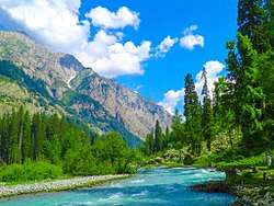
 Kumrat valley upper Dir
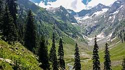 Jahaz Banda in the upper reaches of the valley
 Kumrat valley
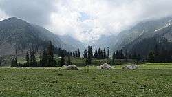
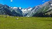
.jpg)
See also
References
- ↑ "Kumrat Valley - 18 Places to See". www.manhoos.com. Retrieved 14 August 2018.
- ↑ https://www.youtube.com/watch?v=yg5lKwdeCMg
- ↑ http://www.dailymotion.com/video/x11tc4p_jahaz-banda-katoora-lake-intro-with-mr-rana-sher-dil_travel
- ↑ Jan, Syed Zahid (2017-12-28). "Deodar forest fast depleting in Dir's Kohistan valley". DAWN.COM. Retrieved 2017-12-28.