U.S. Route 830
| ||||
|---|---|---|---|---|
 | ||||
| Route information | ||||
| Length | 209 mi (336 km) | |||
| Existed | 1926[1]–1968 | |||
| Major junctions | ||||
| West end |
| |||
|
| ||||
| East end |
| |||
| Highway system | ||||
| ||||
.svg.png)
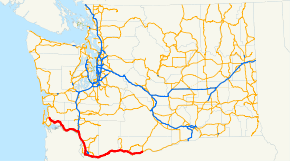
U.S. Route 830, (US 830), was a U.S. Highway which ran between a junction with US 97 near the city of Maryhill, Washington and a junction with US 101 near Ilwaco, Washington. The route still (mostly) exists; however it is currently signed as State Route 14 between Maryhill and Vancouver, Washington, Interstate 5 (I-5) between Vancouver and Longview, State Route 432 for a short stretch through Longview; and State Route 4 from Longview to the western terminus near Ilwaco. The number suggests that US 830 was an auxiliary route of US 30. While US 30 and US 830 never connected, they ran parallel to each other for the entire length of US 830. This route ran on the northern bank of the Columbia River (through Washington) whereas US 30 runs on the river's southern bank, through Oregon.
History
US 830 was created in 1926 as part of the initial set of national numbered highways, running from US 101 at Megler to US 97 near Maryhill.[2] When it existed, US 830 was the highest-numbered route in the U.S. Highway system (and remains the highest U.S. route number ever used). The highest numbered route still in existence is US 730.
The stretch of (former) US 830 which is now I-5 was at one point concurrent with US 99. The stretch of US 830 between Maryhill and Dallesport, Washington was formerly concurrent with US 197 from 1952 onward;[3] now Dallesport is the northern terminus of US 197.
US 830 was decommissioned in 1968 and was replaced by State Route 4, Interstate 5, and State Route 14.[4][5]
Major intersections
| County | Location | mi[6] | km | Destinations[7] | Notes |
|---|---|---|---|---|---|
| Pacific | | 81.82[n 1] | 131.68 | Western terminus | |
| | 87.15 | 140.25 | Connects to US 30 in Astoria. Car & driver toll $1 (1941) ($17 in 2018[8]).[9] | ||
| Wahkiakum | | 97.64 | 157.14 | ||
| | 117.57 | 189.21 | |||
| Cowlitz | Kelso | 145.03 | 233.40 | Western end of US 99 concurrency | |
| Woodland | 21.16[n 2] | 34.05 | |||
| Clark | | 14.17 | 22.80 | ||
| | 9.26 | 14.90 | |||
| Vancouver | 1.52 | 2.45 | |||
| 1.06 | 1.71 | ||||
| 0.00[n 3] | 0.00 | Eastern end of concurrency with US 99 | |||
| Camas | 13.79 | 22.19 | |||
| Washougal | 16.16 | 26.01 | |||
| Skamania | | 25.80 | 41.52 | ||
| | 47.19 | 75.94 | |||
| Klickitat | | 66.06 | 106.31 | ||
| | 83.42 | 134.25 | Western end of US 197 concurrency | ||
| Maryhill | 100.92 | 162.41 | Eastern terminus; eastern end of US 197 concurrency | ||
1.000 mi = 1.609 km; 1.000 km = 0.621 mi
| |||||
See also

- List of United States Numbered Highways
Notes
References
- ↑ Bureau of Public Roads & American Association of State Highway Officials (November 11, 1926). United States System of Highways Adopted for Uniform Marking by the American Association of State Highway Officials (Map). 1:7,000,000. Washington, DC: U.S. Geological Survey. OCLC 32889555. Retrieved November 7, 2013 – via University of North Texas Libraries.
- ↑ Bureau of Public Roads & American Association of State Highway Officials (November 11, 1926). United States System of Highways Adopted for Uniform Marking by the American Association of State Highway Officials (Map). 1:7,000,000. Washington, DC: U.S. Geological Survey. OCLC 32889555. Retrieved October 1, 2017 – via University of North Texas Libraries.
- ↑ Northwest, 1967 (Map). Rand McNally. 1967. Retrieved October 1, 2017.
- ↑ "New Highway 'Most Beautiful'". The Seattle Times. Associated Press. January 16, 1968. p. 14.
- ↑ "Highway 410 Is Now Designated 12". Walla Walla Union-Bulletin. February 12, 1968. p. 11.
- ↑ "Annual Traffic Report" (PDF). Washington Highway Commission. 1960. pp. 37&ndash, 38, 100&ndash, 103, 123&ndash, 124. Retrieved November 21, 2010.
- ↑ Washington State Highways (DjVu) (Map). Washington State Highway Commission. 1950. Retrieved November 21, 2010.
- ↑ Federal Reserve Bank of Minneapolis Community Development Project. "Consumer Price Index (estimate) 1800–". Federal Reserve Bank of Minneapolis. Retrieved January 2, 2018.
- ↑ Federal Writers' Project. Washington: A Guide to the Evergreen State. US History Publishers. p. 413. ISBN 978-1-60354-046-9. Archived from the original on December 3, 2016. Retrieved November 21, 2010.
External links

- Historic endpoints of U.S. Highway 830