Ridgefield, Washington
| Ridgefield, Washington | |
|---|---|
| Town | |
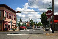 Downtown Ridgefield | |
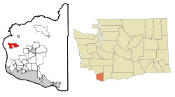 Location of Ridgefield, Washington | |
| Coordinates: 45°48′55″N 122°43′40″W / 45.81528°N 122.72778°WCoordinates: 45°48′55″N 122°43′40″W / 45.81528°N 122.72778°W | |
| Country | United States |
| State | Washington |
| County | Clark |
| Area[1] | |
| • Total | 7.18 sq mi (18.60 km2) |
| • Land | 7.08 sq mi (18.34 km2) |
| • Water | 0.10 sq mi (0.26 km2) |
| Elevation | 112 ft (34 m) |
| Population (2010)[2] | |
| • Total | 4,763 |
| • Estimate (2015)[3] | 6,455 |
| • Density | 672.7/sq mi (259.7/km2) |
| Time zone | UTC-8 (Pacific (PST)) |
| • Summer (DST) | UTC-7 (PDT) |
| ZIP code | 98642 |
| Area code | 360 |
| FIPS code | 53-58410 |
| GNIS feature ID | 1512604[4] |
| Website | www.ci.ridgefield.wa.us |
Ridgefield is a city in the pastoral, rolling-hills countryside of northern Clark County, Washington, in the United States. The population was 4,763 at the 2010 census.[5]
Located within the Portland metropolitan region, Ridgefield is notable for the significant Native American and Lewis and Clark Expedition history of the area, but is also the headquarters of the Ridgefield National Wildlife Refuge, a primary reserve for migrating waterfowl on the Pacific Flyway, and the Ridgefield High School "Spudders" (reflecting the area's potato-farming heritage). The city is home to several annual community events, such as their old-fashioned Fourth of July Celebration, and also holds a bird festival that attracts bird lovers from around the region and beyond.
History
The area has important ties to the Lewis and Clark Expedition of 1804–1806, being close to the Chinookan town of Cathlapotle, then a settlement of 700-800 people, with at least 14 substantial plank houses.[6] The community's ties to the Chinookan people was commemorated by the construction of a replica of a Cathlapotle plank house at the nearby Ridgefield National Wildlife Refuge, which was dedicated March 29, 2005.[7]
The town was formerly known as Union Ridge, named by the many Union veterans among the first large wave of settlers after the Civil War[8] and was renamed Ridgefield in 1890.[9] The town's original name is preserved in the name of Union Ridge Elementary School.[10]
Ridgefield was an important trading center as early as the 1860s with its key location near the mouth of the Columbia River, and the city was officially incorporated on August 26, 1909. U-Haul, an American equipment rental company, had its start in Ridgefield in 1945.[11]
Geography
According to the United States Census Bureau, the city has a total area of 7.18 square miles (18.60 km2), of which, 7.08 square miles (18.34 km2) is land and 0.10 square miles (0.26 km2) is water.[1][12]
Demographics
| Historical population | |||
|---|---|---|---|
| Census | Pop. | %± | |
| 1910 | 297 | — | |
| 1920 | 620 | 108.8% | |
| 1930 | 607 | −2.1% | |
| 1940 | 643 | 5.9% | |
| 1950 | 762 | 18.5% | |
| 1960 | 823 | 8.0% | |
| 1970 | 1,004 | 22.0% | |
| 1980 | 1,062 | 5.8% | |
| 1990 | 1,297 | 22.1% | |
| 2000 | 2,147 | 65.5% | |
| 2010 | 4,763 | 121.8% | |
| Est. 2016 | 7,066 | [13] | 48.4% |
| U.S. Decennial Census[14] 2015 Estimate[3] | |||
2010 census
As of the census[2] of 2010, there were 4,763 people, 1,591 households, and 1,258 families residing in the city. The population density was 672.7 inhabitants per square mile (259.7/km2). There were 1,695 housing units at an average density of 239.4 per square mile (92.4/km2). The racial makeup of the city was 92.4% White, 0.9% African American, 0.8% Native American, 2.0% Asian, 0.1% Pacific Islander, 0.9% from other races, and 2.8% from two or more races. Hispanic or Latino of any race were 5.1% of the population.
There were 1,591 households of which 48.1% had children under the age of 18 living with them, 62.0% were married couples living together, 11.6% had a female householder with no husband present, 5.5% had a male householder with no wife present, and 20.9% were non-families. 16.2% of all households were made up of individuals and 6.1% had someone living alone who was 65 years of age or older. The average household size was 2.99 and the average family size was 3.34.
The median age in the city was 32.4 years. 33.5% of residents were under the age of 18; 6.2% were between the ages of 18 and 24; 29.7% were from 25 to 44; 22.9% were from 45 to 64; and 7.7% were 65 years of age or older. The gender makeup of the city was 49.9% male and 50.1% female.
2000 census
As of the census of 2000, there were 2,147 people, 739 households, and 557 families residing in the city. The population density was 420.8 people per square mile (162.5/km²). There were 777 housing units at an average density of 152.3 per square mile (58.8/km²). The racial makeup of the city was 95.16% White, 0.28% African American, 1.12% Native American, 0.70% Asian, 0.05% Pacific Islander, 0.23% from other races, and 2.47% from two or more races. Hispanic or Latino of any race were 1.77% of the population. 20.4% were of German, 18.9% American, 11.9% English, 6.9% Irish and 6.2% Norwegian ancestry.
There were 739 households out of which 43.8% had children under the age of 18 living with them, 58.6% were married couples living together, 11.8% had a female householder with no husband present, and 24.6% were non-families. 18.8% of all households were made up of individuals and 8.0% had someone living alone who was 65 years of age or older. The average household size was 2.82 and the average family size was 3.18.
In the city, the age distribution of the population shows 29.8% under the age of 18, 7.6% from 18 to 24, 29.6% from 25 to 44, 22.4% from 45 to 64, and 10.7% who were 65 years of age or older. The median age was 36 years. For every 100 females, there were 98.1 males. For every 100 females age 18 and over, there were 94.8 males.
The median income for a household in the city was $46,012, and the median income for a family was $51,121. Males had a median income of $38,125 versus $27,426 for females. The per capita income for the city was $21,696. About 4.4% of families and 6.3% of the population were below the poverty line, including 6.6% of those under age 18 and 9.0% of those age 65 or over.
Education
The Ridgefield school district has four schools: Union Ridge Elementary, South Ridge Elementary, View Ridge Middle School, and Ridgefield High School.
Notable people
- Scott Mosier, film producer and podcaster
- Richie Sexson, former major league baseball player
References
- 1 2 "US Gazetteer files 2010". United States Census Bureau. Archived from the original on 2011-02-20. Retrieved 2012-12-19.
- 1 2 "American FactFinder". United States Census Bureau. Retrieved 2012-12-19.
- 1 2 "Population Estimates". United States Census Bureau. Archived from the original on October 19, 2016. Retrieved July 1, 2016.
- ↑ U.S. Geological Survey Geographic Names Information System: Ridgefield, Washington
- ↑ "2010 Census Redistricting Data (Public Law 94-171) Summary File". American FactFinder. United States Census Bureau. Archived from the original on July 21, 2011. Retrieved 16 September 2012.
- ↑ Ames, Kenneth. "Cathlapotle". The Oregon Encyclopedia. The Oregon Historical Society. Retrieved 3 November 2017.
- ↑ Caldbick, John (January 24, 2010). "Ridgefield — Thumbnail History". History Link.
- ↑ Kirk, Ruth; Alexander, Carmela (995). Exploring Washington's Past: A Road Guide to History. University of Washington Press. p. 405. Retrieved 20 November 2017.
- ↑ Wilhelm, Honor L. (1 January 1908). "The Coast". Coast Publishing Company. Retrieved 5 July 2016 – via Google Books.
- ↑ Caldbick, John (January 24, 2010). "Ridgefield — Thumbnail History". History Link.
- ↑ Caldbick, John (January 24, 2010). "Ridgefield — Thumbnail History". History Link.
- ↑ "US Gazetteer files: 2010, 2000, and 1990". United States Census Bureau. 2011-02-12. Retrieved 2011-04-23.
- ↑ "Population and Housing Unit Estimates". Retrieved June 9, 2017.
- ↑ United States Census Bureau. "Census of Population and Housing". Archived from the original on May 12, 2015. Retrieved September 19, 2013.
External links
| Wikimedia Commons has media related to Ridgefield, Washington. |
Municipalities and communities of Clark County, Washington, United States | ||
|---|---|---|
| Cities |  | |
| Town | ||
| CDPs | ||
| Other unincorporated communities | ||
| Footnotes | ‡This populated place also has portions in an adjacent county or counties | |