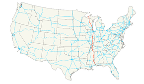
U.S. Route 45
| |
|---|---|
 | |
| Route information | |
| Length | 1,297 mi (2,087 km) |
| Existed | 1926–present |
| Major junctions | |
| South end |
|
|
| |
| North end | Ontonagon and River streets in Ontonagon, MI |
| Location | |
| States | Alabama, Mississippi, Tennessee, Kentucky, Illinois, Wisconsin, Michigan |
| Highway system | |

U.S. Route 45 is a major north–south United States highway and a border-to-border route, from Lake Superior to the Gulf of Mexico. A sign at the highway's northern terminus notes the total distance as 1,300 miles (2,100 km).
US 45 is notable for incorporating, in its maiden alignment, the first paved road in the South, a 49-mile segment in Lee County, Mississippi. Let to contract in July 1914, the concrete highway opened on November 15, 1915.[1]
As of 2006, the highway's northern terminus is in Ontonagon, Michigan, at the corner of Ontonagon and River Streets, a few blocks from Lake Superior. M-64 formerly terminated there as well until its rerouting in October 2006 to use the newly built Ontonagon River Bridge. Its southern terminus is in Mobile, Alabama, at an intersection with U.S. Route 98.
Route description
Alabama
US 45 is concurrent with unsigned SR 17 between Mobile and Vinegar Bend, just north of Deer Park, in Washington County, Alabama. From Vinegar Bend to the Mississippi state line, US 45 is concurrent with unsigned SR 57.
Mississippi

U.S. Highway 45 is part of a designated hurricane evacuation route in Mississippi.[2] It is entirely four-laned from its point of entry from Alabama, at the town of State Line, to the Tennessee line just north of Corinth, along the way serving the towns of (from south to north) Waynesboro, Meridian, Columbus and Tupelo.[3]
At Brooksville, U.S. 45 splits away from U.S. 45 Alternate and serves the towns of Columbus and Aberdeen before rejoining U.S. 45 Alternate south of Tupelo. The alternate roadway provides a more direct and entirely four-laned route between Meridian and Tupelo, bypassing Columbus to the west and, more closely, Starkville to the east.
Major junctions of U.S. 45 in Mississippi include U.S. Route 84 at Waynesboro, Interstate 20/59 at Meridian, U.S. Route 82 at Columbus, Interstate 22/U.S. Route 78 at Tupelo and U.S. Route 72 at Corinth. Each of these junctions is an interchange and, with the exception of Waynesboro, each is part of a freeway segment.
The Mississippi section of U.S. 45 is defined at Mississippi Code Annotated § 65-3-3.
Tennessee
From the Mississippi state line U.S. 45 extends north past Selmer and Henderson and Jackson to Three Way, just north of Jackson. At Three Way, the highway splits into U.S. 45E and U.S. 45W.
From Three Way to the northeast, U.S. 45E extends past Milan and Martin and is concurrent with unsigned State Route 43 for most of the route's length past except for short segments at South Fulton where it is cosigned with State Route 216 and State Route 215 respectively. From Three Way to the northwest, U.S. 45W extends past Humboldt and is concurrent with unsigned State Route 5 to Union City and then with U.S. 51 (unsigned SR 3) to the junction with U.S. 45E less than a quarter mile south of the Kentucky state line. Mainline U.S. 45, concurrent with U.S. 51, continues north into Kentucky.
Kentucky
U.S. 45 enters Kentucky at Fulton then northeast past Mayfield then heads directly north into Paducah as a four-lane highway. In Paducah, U.S. 45 serves as a major artery, intersecting with Interstate 24 at exit 7, and intersecting US 60 and 62. U.S. 45 leaves Kentucky from Paducah's northern border across the two-lane, metal-grate Brookport Bridge to Brookport, Illinois across the Ohio River.
Illinois
In the state of Illinois, U.S. 45 runs from a bridge across the Ohio River from Paducah, Kentucky, through Shawnee National Forest and north to the Wisconsin border east of Antioch, Illinois. With a length of 428.99 miles (690.39 km) in Illinois,[4] U.S. 45 is the longest numbered route in Illinois.
In its progress north from the Ohio River U.S. 45 first joins Interstate 24 as far as Vienna then heads northeast through Harrisburg and north through Fairfield, Flora, Effingham, Mattoon, Champaign, Urbana, Gilman and Kankakee, then straight north through the western suburbs of Chicago in Will County, Cook County and Lake County to the Wisconsin border.
Wisconsin
U.S. 45 enters the state in southeast Wisconsin. It runs concurrent with Interstate 894 and U.S. Route 41 through the west side of metro Milwaukee to form a major artery through the metropolitan area. It runs north to Fond du Lac. The highway routes near the western shore of Lake Winnebago through Oshkosh, Wisconsin. U.S. 45 then travels north through Wittenberg, Antigo, and Eagle River, as well as the state and national forests, until it leaves the state at Land O' Lakes and enters Michigan.
Michigan
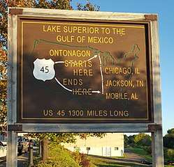
US 45 enters Michigan south of Watersmeet. From there, the highway crosses the Western Upper Peninsula through the Ottawa National Forest running north to Ontonagon. US 45 ends just south of Lake Superior in downtown Ontonagon. The terminus was not changed in 2006 despite realignment then of M-38 and M-64 from the terminus to a crossing 0.7 miles (1.1 km) south.[5]
Historic termini
Until March 1935, US 45's northern terminus was in the Chicago, Illinois area.[6]
Prior to the construction of the Interstate Highway system, US 45 was one of the main routes south out of Chicago toward New Orleans, Louisiana. Much of the traffic left US 45 at Effingham, Illinois, continuing on through Cairo, Illinois along Illinois Route 37.
Major intersections
- Southern segment
- Alabama
- Mississippi
- Tennessee
- Northern segment
- Tennessee


- Kentucky
- Illinois


- Wisconsin


- Michigan

- River Street/Chippewa Street in Ontonagon
See also
- U.S. Route 45 Business in Wittenburg, Wisconsin
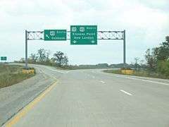
- U.S. Route 45 Business in New London, Wisconsin
- U.S. Route 45 Business in Paducah, Kentucky
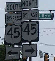
- U.S. Route 45 Bypass in Jackson, Tennessee
- U.S. Route 45W Business in Trenton, Tennessee; decommissioned and re-signed as State Route 367
- U.S. Route 45W Business in Humboldt, Tennessee
- U.S. Route 45E Business in Martin, Tennessee
- U.S. Route 45 Business in Tupelo, Mississippi
- U.S. Route 45 Business in Meridian, Mississippi
References
- ↑ USDOT Federal Highway Administration: The Evolution of Mississippi Highways Archived 2011-06-24 at the Wayback Machine.. Retrieved 15 February 2011.
- ↑ MS Dept. of Transportation's Hurricane Evacuation Map Archived 2011-09-08 at the Wayback Machine., retrieved 30 Aug 2011
- ↑ Official Mississippi Highway Map, pdf version Archived 2012-03-20 at the Wayback Machine., retrieved 30 Aug 2011.
- ↑ Illinois Technology Transfer Center. Called La Grange Road through much of the South Suburbs of Chicago. (2007). "T2 GIS Data". Archived from the original on 2007-08-10. Retrieved November 8, 2007.
- ↑ Bessert, Christopher J. Michigan Highways: Ontonagon State Trunkline Changes 2006 Archived 2007-06-29 at the Wayback Machine.. URL accessed 24 June 2007.
- ↑ "Route 45 Extended". The Daily Herald. December 12, 2016. p. 1. Archived from the original on 2016-12-20. Retrieved December 12, 2016 – via Newspapers.com.

External links
| Wikimedia Commons has media related to U.S. Route 45. |
Routes in italics are no longer a part of the system. Highlighted routes are considered main routes of the system. |
| Browse numbered routes | ||||
|---|---|---|---|---|
| ← | AL | SR 46 | ||
| ← | MS | MS 46 | ||
| ← | TN | SR 45 | ||