Jackson Township, Huntington County, Indiana
| Jackson Township | |
|---|---|
| Township | |
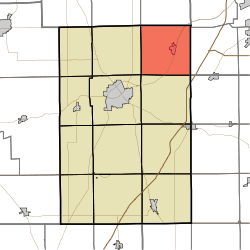 Location in Huntington County | |
| Coordinates: 40°57′38″N 85°23′49″W / 40.96056°N 85.39694°WCoordinates: 40°57′38″N 85°23′49″W / 40.96056°N 85.39694°W | |
| Country | United States |
| State | Indiana |
| County | Huntington |
| Government | |
| • Type | Indiana township |
| Area | |
| • Total | 36.85 sq mi (95.4 km2) |
| • Land | 36.41 sq mi (94.3 km2) |
| • Water | 0.44 sq mi (1.1 km2) 1.19% |
| Elevation | 784 ft (239 m) |
| Population (2010) | |
| • Total | 4,043 |
| • Density | 111/sq mi (43/km2) |
| GNIS feature ID | 0453450 |
Jackson Township is one of twelve townships in Huntington County, Indiana, United States. As of the 2010 census, its population was 4,043 and it contained 1,704 housing units.[1]
History
Jackson Township was organized in 1841.[2]
Geography
According to the 2010 census, the township has a total area of 36.85 square miles (95.4 km2), of which 36.41 square miles (94.3 km2) (or 98.81%) is land and 0.44 square miles (1.1 km2) (or 1.19%) is water.[1]
Cities and towns
Unincorporated towns
Adjacent townships
- Jefferson Township, Whitley County (north)
- Aboite Township, Allen County (northeast)
- Lafayette Township, Allen County (east)
- Union Township, Wells County (southeast)
- Union Township (south)
- Huntington Township (southwest)
- Clear Creek Township (west)
- Washington Township, Whitley County (northwest)
Cemeteries
The township contains two cemeteries: France and Union.
Major highways
Airports and landing strips
- Fisher Farm Airport
- The Wolf Den Airport
References
- "Jackson Township, Huntington County, Indiana". Geographic Names Information System. United States Geological Survey. Retrieved 2009-09-24.
- United States Census Bureau cartographic boundary files
- 1 2 "Population, Housing Units, Area, and Density: 2010 - County -- County Subdivision and Place -- 2010 Census Summary File 1". United States Census. Retrieved 2013-05-10.
- ↑ History of Huntington County, Indiana: From the Earliest Time to the Present. Brant & Fuller. 1887. p. 638.
External links
Municipalities and communities of Huntington County, Indiana, United States | ||
|---|---|---|
| City | ||
| Towns | ||
| Townships | ||
| Unincorporated communities | ||
| Footnotes | ‡This populated place also has portions in an adjacent county or counties | |
This article is issued from
Wikipedia.
The text is licensed under Creative Commons - Attribution - Sharealike.
Additional terms may apply for the media files.