Lees Mill, New Hampshire
| Lees Mill, New Hampshire | |
|---|---|
| Unincorporated community | |
 Lees Mill  Lees Mill | |
| Coordinates: 43°44′21″N 71°23′23″W / 43.73917°N 71.38972°WCoordinates: 43°44′21″N 71°23′23″W / 43.73917°N 71.38972°W | |
| Country | United States |
| State | New Hampshire |
| County | Carroll |
| Town | Moultonborough |
| Elevation | 518 ft (158 m) |
| Time zone | UTC-5 (Eastern (EST)) |
| • Summer (DST) | UTC-4 (EDT) |
| Area code(s) | 603 |
| GNIS feature ID | 871198[1] |
Lees Mill (also Balmoral) is an unincorporated community in the town of Moultonborough, in Carroll County, New Hampshire, United States.[1] It is located adjacent to the outlet of Lees Pond, directly upstream from the northernmost point of Lake Winnipesaukee.
References
Municipalities and communities of Carroll County, New Hampshire, United States | ||
|---|---|---|
| Towns | 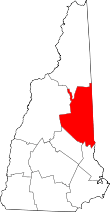 | |
| Township | ||
| CDPs | ||
| Other villages | ||
This article is issued from
Wikipedia.
The text is licensed under Creative Commons - Attribution - Sharealike.
Additional terms may apply for the media files.