Tromelin Island
| Tromelin Island French: L'Île Tromelin | |
|---|---|
 Flag | |
|
Motto: "Liberté, égalité, fraternité" | |
|
Anthem: La Marseillaise | |
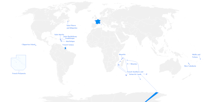
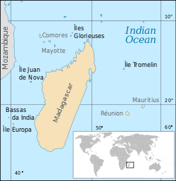 Location of Tromelin and other islands in the Indian Ocean | |
| Official languages | French |
| French overseas territory | |
• Discovery by Jean Marie Briand de la Feuillée | 1722 |
• French claim to sovereignty | 29 november 1776 |
| Currency | Euro (EUR) |
| ISO 3166 code | TF |
| Internet TLD | .tf |
Tromelin Island (/ˌtroʊmlɪn
Tromelin has facilities for scientific expeditions and a weather station.[2] It is a nesting site for birds and green sea turtles.
Etymology
The island is named for the chevalier Bernard Boudin de Tromelin, the captain of the French warship La Dauphine. He arrived at the island on 29 November 1776, and rescued 8 stranded enslaved Africans who had been on the island for 15 years. p
Description


As Tromelin is only 7 metres (23 ft) high, studies could not determine if it is the summit of a volcano or an atoll.
Tromelin is about 1,700 metres (1.1 mi) long and 700 metres (0.43 mi) wide, with an area of 80 ha (200 acres), covered in scrub dominated by octopus bush[3] and surrounded by coral reefs. There are no harbours or anchorages, so that access by sea is quite difficult. A 1,200-metre (3,900 ft) airstrip provides a link with the outside world.[4]
Important Bird Area
The island has been identified as an Important Bird Area (IBA) by BirdLife International because of its significance as a seabird breeding site. Both masked (with up to 250 pairs) and red-footed boobies (up to 180 pairs) nesting there. Sulidae populations have seriously declined in the western Indian Ocean with those on Tromelin among the healthiest remaining.
The island's masked boobies are of the western Indian Ocean subspecies (Sula dactylatra melanops), of which Tromelin is a stronghold.[5] The red-footed boobies constitute the only polymorphic population in the region, indicating its biogeographical isolation. Both great and lesser frigatebirds used to nest on the island. The breeding populations of both birds have since been extirpated, although they continue to use the island for roosting.
There are no resident landbirds.[3]
History

The island was discovered by France in 1720s.[6][7] It was recorded by the French navigator Jean Marie Briand de la Feuillée and named "Île des Sables" ('Island of Sands').[8]
Wreck of the slave ship L'Utile
In 1761 the French ship L'Utile (The Useful), carrying slaves from Madagascar to Mauritius, ran onto the reefs of the island.[9]
On September 27, 1761, the 123 person French contingent, crew and officers, left Tromelin aboard the raft, Providence, which they had built with the available wood from the wreckage of the L'Utile. They left the slaves – sixty Malagasy men and women – on the desert island; promising to return and rescue them.[9][10] When the crew of the ship reached Madagascar they requested that the colonial authorities send a ship to rescue the people on the island.[9] However, they met with a categorical refusal, based on the fact that France was fighting the Seven Years' War and thus no ship could be spared.
The Malagasy people, who had been left on the bleak little island, built a shed with coral stones, for most of the wood had been used in the construction of the raft for the crew, and there were no trees on the island. They also built a lookout on the highest point of the island in order not to miss the ship that would, they hoped, come to their rescue. They were all from the Central Highlands of Madagascar, and had no knowledge of how to produce food in the marine environment. Most died within the first few months.[8]
Fifteen years later, in 1776, the French warship La Dauphine, arrived at the island. They rescued the survivors – seven women and an eight-month-old child.[11][10]
Sovereignty claims
The French claim to sovereignty dates from 29 November 1776,[12] the date that the ship La Dauphine arrived.
The Mauritian claim to sovereignty is based on the fact that the island was not ceded to France by the treaty of Paris in 1814.
The United Nations never recognized the Mauritian sovereignty over Tromelin. In 1954, France constructed a meteorological station and a landing strip on the island.[13]
It is a matter of dispute whether the building agreement transferred sovereignty of Tromelin from one to the other, and Mauritius claims the island as part of its territory, on the grounds that sovereignty was not transferred to France in 1814, and the island was thus part of the colony of Mauritius at the time of independence.[14] Indeed, as early as 1959, even before independence, Mauritius informed the World Meteorological Organization that it considered Tromelin to be part of its territory.[15] France and Mauritius reached a co-management treaty in 2010.[16]
Tromelin has an Exclusive Economic Zone (EEZ) of 280,000 square kilometres (108,109 square miles), contiguous with that of Réunion. The island's weather station, which warns of cyclones, is still operated by France and is staffed by meteorologists from Réunion.
Climate
| Climate data for Tromelin Island (1981–2010 averages, records 1955–present) | |||||||||||||
|---|---|---|---|---|---|---|---|---|---|---|---|---|---|
| Month | Jan | Feb | Mar | Apr | May | Jun | Jul | Aug | Sep | Oct | Nov | Dec | Year |
| Record high °C (°F) | 36.3 (97.3) |
34.9 (94.8) |
34.4 (93.9) |
33.3 (91.9) |
31.6 (88.9) |
30.0 (86) |
28.5 (83.3) |
28.8 (83.8) |
29.2 (84.6) |
30.4 (86.7) |
33.8 (92.8) |
33.9 (93) |
36.3 (97.3) |
| Average high °C (°F) | 31.0 (87.8) |
31.0 (87.8) |
30.8 (87.4) |
30.0 (86) |
28.8 (83.8) |
27.2 (81) |
26.2 (79.2) |
26.3 (79.3) |
26.8 (80.2) |
27.9 (82.2) |
29.1 (84.4) |
30.3 (86.5) |
28.8 (83.8) |
| Daily mean °C (°F) | 28.4 (83.1) |
28.5 (83.3) |
28.3 (82.9) |
27.7 (81.9) |
26.6 (79.9) |
25.0 (77) |
24.0 (75.2) |
24.0 (75.2) |
24.4 (75.9) |
25.4 (77.7) |
26.5 (79.7) |
27.8 (82) |
26.4 (79.5) |
| Average low °C (°F) | 25.8 (78.4) |
26.0 (78.8) |
25.9 (78.6) |
25.4 (77.7) |
24.4 (75.9) |
22.8 (73) |
21.8 (71.2) |
21.6 (70.9) |
22.0 (71.6) |
22.9 (73.2) |
23.9 (75) |
25.2 (77.4) |
24.0 (75.2) |
| Record low °C (°F) | 20.5 (68.9) |
22.3 (72.1) |
20.9 (69.6) |
20.8 (69.4) |
19.5 (67.1) |
18.1 (64.6) |
17.4 (63.3) |
17.8 (64) |
18.0 (64.4) |
18.2 (64.8) |
19.6 (67.3) |
20.5 (68.9) |
17.4 (63.3) |
| Average precipitation mm (inches) | 137.4 (5.409) |
187.8 (7.394) |
156.0 (6.142) |
128.7 (5.067) |
69.1 (2.72) |
66.9 (2.634) |
65.2 (2.567) |
51.9 (2.043) |
47.4 (1.866) |
30.9 (1.217) |
33.9 (1.335) |
99.1 (3.902) |
1,074.3 (42.295) |
| Average precipitation days (≥ 1.0 mm) | 12.1 | 13.8 | 14.7 | 12.3 | 10.2 | 11.3 | 12.9 | 11.6 | 9.1 | 7.6 | 6.3 | 9.6 | 131.4 |
| Source: Météo France[17] | |||||||||||||
References
- ↑ "CHAGOS ARCHIPELAGO AND TROMELIN ISLAND – MAURITIUS SOVEREIGNTY" (PDF). National Assembly (Mauritius). Retrieved 6 September 2015.
- ↑ New Scientist. New Science Publications. January 1995.
- 1 2 BirdLife International. (2012). Important Bird Areas factsheet: Tromelin. Downloaded from http://www.birdlife.org on 2012-01-07.
- ↑ Atoll Research Bulletin. Smithsonian Institution. 1951.
- ↑ African Wildlife. Wildlife Society of Southern Africa. 1974.
- ↑ Russell, James; Russell, James (11 April 2016). "The Recovery of Tromelin Island". National Geographic Society (blogs). Retrieved 26 August 2017.
- ↑ United States. Central Intelligence Agency; Government Publications Office (18 August 2016). The World Factbook 2016-17. Government Printing Office. pp. 269–. ISBN 978-0-16-093327-1.
- 1 2 "La Revue Maritime N° 477. Décembre 2006 Institut Français de la Mer - 47, rue de Monceau - 75008 Paris" (PDF). Ifm.free.fr. Retrieved 26 August 2017.
- 1 2 3 "Lèse humanité". The Economist. Retrieved 26 August 2017.
- 1 2 "Shipwrecked and abandoned: the story of the slave Crusoes". Independent.co.uk. 5 February 2007. Retrieved 26 August 2017.
- ↑ Marriner, N.; Guérout, M.; Romon, T. (2010). "The Forgotten Slaves of Tromelin (Indian Ocean): New Geoarchaeological Data". Journal of Archaeological Science. 37 (6): 1293–1304. doi:10.1016/j.jas.2009.12.032.
- ↑ "Ce n'est que quinze ans plus tard, le 29 novembre 1776, que le chevalier de Tromelin récupérera huit esclaves survivants : sept femmes et un enfant de huit mois. Le pavillon français fut planté sur l'île qui fut ainsi nommée Tromelin en hommage à ce chevalier.". Web.archive.org. Archived from the original on 2012-01-31. Retrieved 2017-08-26.
- ↑ Charney, Jonathan I.; Colson, David A.; Alexander, Lewis M. (2005). International Maritime Boundaries. p. 3463. ISBN 9004144617.
- ↑ Forbes, Vivian Louis (1995). The maritime boundaries of the Indian Ocean region. Singapore University Press. p. 110. ISBN 9971691892.
- ↑ Rumley, Dennis; Chaturvedi, Sanjay; Sakhuja, Vijay (2010). Fisheries Exploitation in the Indian Ocean: Threats and Opportunities. p. 123. ISBN 9789812309860.
- ↑ "Tromelin : La Réunion, spectatrice et spoliée". Lequotidien.re.
- ↑ "Tromelin (984)" (PDF). Fiche Climatologique: Statistiques 1981–2010 et records (in French). Meteo France. Archived from the original (PDF) on 27 February 2018. Retrieved 26 February 2018.
External links
| Wikimedia Commons has media related to Tromelin. |
- "Shipwrecked and abandoned: the story of the slave Crusoes" by John Lichfield, The Independent 5 February 2007
- Lèse humanité: What happened when slaves and free men were shipwrecked together, The Economist 19 December 2015
- Tromelin, la isla de los malgaches resilentes (in Spanish)
Coordinates: 15°53′32″S 54°31′29″E / 15.89222°S 54.52472°E
| |||||||||||||
| |||||||||||||
| |||||||||||||