Juan de Nova Island
| Juan de Nova Island Île Juan de Nova | |
|---|---|
 Flag | |
|
Motto: "Liberté, égalité, fraternité" | |
|
Anthem: La Marseillaise | |
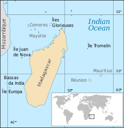 Locations of some of the scattered islands in the Indian Ocean, including Juan de Nova. |
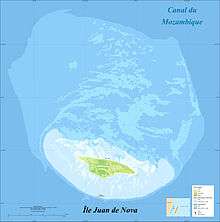
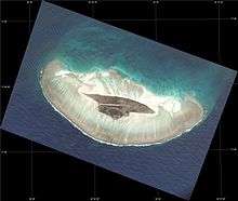
Juan de Nova Island (French: Île Juan da Nova (official), Île Juan de Nova (local)), also known as Saint-Christophe, is a French 4.4 square kilometres (1.7 sq mi) low, flat, tropical island in the narrowest part of the Mozambique Channel, about one-third of the way between Madagascar and Mozambique. Anchorage is possible off the northeast of the island which also has a 1,300 metres (4,300 ft) airstrip. Administratively, the island is one of the Scattered islands in the Indian Ocean, a district of the French Southern and Antarctic Lands. The island is garrisoned by French troops from Réunion and has a weather station.[1]
Description
Juan de Nova, about 6 kilometres (3.7 mi) long and 1.6 kilometres (0.99 mi) at its widest, is a nature reserve surrounded by reefs which enclose an area (not a true lagoon like in an atoll) of roughly 40 square kilometres (15 sq mi). Forests, mainly of Casuarinaceae, cover about half the island. Sea turtles nest on the beaches around the island.
Important Bird Area
The island has been identified as an Important Bird Area (IBA) by BirdLife International because it supports a very large colony of sooty terns, with up to 100,000 breeding pairs. It also has a much smaller colony of greater crested terns (with at least 50 breeding pairs recorded in 1994). Of at least seven species of landbirds present, most are probably introduced.[2]
History
The island is named after the Spanish version of a Galician admiral in the service of Portugal (Xoán da Nova or de Novoa in Galician; João da Nova in Portuguese) who came across the island in 1501. The island had never been inhabited when it became a possession of France in 1897.[3] In 1921, France decided to transfer the administration of Juan de Nova from Paris to Tananarive in its colony of Madagascar and Dependencies. Before the independence of Madagascar, France transferred the administration to Saint-Pierre on Réunion Island. Madagascar became independent in 1960 and claims sovereignty over the island since 1972. Guano (phosphate) deposits were exploited from the start of the 20th century until 1970. The island was abandoned during World War II and was visited by German submariners. Installations, including a hangar, rail lines, houses and a jetty are in ruins.
Wrecks
The island lies on the sea route between South Africa and the northern tip of Madagascar. It is affected by strong currents, and has become the site of numerous wrecks. Most visible are the remains of the SS Tottenham which ran onto the southern fringing reef in 1911.
Climate
| Climate data for Juan de Nova Island | |||||||||||||
|---|---|---|---|---|---|---|---|---|---|---|---|---|---|
| Month | Jan | Feb | Mar | Apr | May | Jun | Jul | Aug | Sep | Oct | Nov | Dec | Year |
| Record high °C (°F) | 34 (93) |
33 (91) |
33 (91) |
33 (91) |
33 (91) |
33 (91) |
32 (90) |
33 (91) |
33 (91) |
32 (90) |
34 (93) |
35 (95) |
35 (95) |
| Average high °C (°F) | 30.1 (86.2) |
30.0 (86) |
30.4 (86.7) |
30.2 (86.4) |
28.9 (84) |
27.4 (81.3) |
26.8 (80.2) |
26.9 (80.4) |
27.7 (81.9) |
28.8 (83.8) |
29.9 (85.8) |
30.4 (86.7) |
28.9 (84) |
| Daily mean °C (°F) | 28.3 (82.9) |
28.2 (82.8) |
28.6 (83.5) |
28.3 (82.9) |
27.2 (81) |
25.7 (78.3) |
24.9 (76.8) |
25.0 (77) |
25.6 (78.1) |
26.7 (80.1) |
27.8 (82) |
28.4 (83.1) |
27.1 (80.8) |
| Average low °C (°F) | 26.6 (79.9) |
26.5 (79.7) |
26.8 (80.2) |
26.8 (80.2) |
25.8 (78.4) |
24.3 (75.7) |
23.4 (74.1) |
23.3 (73.9) |
23.7 (74.7) |
24.7 (76.5) |
25.8 (78.4) |
26.4 (79.5) |
25.3 (77.5) |
| Record low °C (°F) | 20 (68) |
16 (61) |
20 (68) |
21 (70) |
20 (68) |
19 (66) |
18 (64) |
17 (63) |
19 (66) |
19 (66) |
19 (66) |
22 (72) |
16 (61) |
| Average precipitation mm (inches) | 324 (12.76) |
289 (11.38) |
140 (5.51) |
21 (0.83) |
18 (0.71) |
9 (0.35) |
11 (0.43) |
4 (0.16) |
1 (0.04) |
8 (0.31) |
22 (0.87) |
139 (5.47) |
986 (38.82) |
| Average precipitation days (≥ 0.1 mm) | 13 | 13 | 9 | 5 | 3 | 3 | 2 | 1 | 1 | 2 | 3 | 10 | 65 |
| Average relative humidity (%) | 80 | 81 | 78 | 74 | 71 | 70 | 71 | 72 | 74 | 75 | 75 | 77 | 75 |
| Mean monthly sunshine hours | 229.4 | 203.4 | 257.3 | 276.0 | 282.1 | 273.0 | 275.9 | 285.2 | 282.0 | 313.1 | 300.0 | 251.1 | 3,228.5 |
| Mean daily sunshine hours | 7.4 | 7.2 | 8.3 | 9.2 | 9.1 | 9.1 | 8.9 | 9.2 | 9.4 | 10.1 | 10.0 | 8.1 | 8.8 |
| Source: Deutscher Wetterdienst[4] | |||||||||||||
References
- ↑ http://www.ethnia.org/ethnia-fiche.php?ask=FR-DT-DM-RE-XL-JU
- ↑ BirdLife International. (2012). Important Bird Areas factsheet: Juan de Nova. Downloaded from http://www.birdlife.org on 2012-01-07.
- ↑ "Archived copy". Archived from the original on 29 January 2012. Retrieved 2011-12-15.
- ↑ "Klimatafel von Juan de Nova (Insel), Iles Desirades / Indischer Ozean / Frankreich" (PDF). Baseline climate means (1961-1990) from stations all over the world (in German). Deutscher Wetterdienst. Retrieved 5 April 2017.
| Wikivoyage has a travel guide for Juan de Nova Island. |
| |||||||||||||
| |||||||||||||
| |||||||||||||
Coordinates: 17°03′16″S 42°43′30″E / 17.05444°S 42.72500°E