Pantelleria
| Pantelleria | ||
|---|---|---|
| Comune | ||
| Comune di Pantelleria | ||
 Panorama of Pantelleria | ||
| ||
 Pantelleria Location of Pantelleria in Sicily  Pantelleria Pantelleria (Italy) | ||
| Coordinates: 36°50′N 11°57′E / 36.833°N 11.950°ECoordinates: 36°50′N 11°57′E / 36.833°N 11.950°E | ||
| Country | Italy | |
| Region | Sicily | |
| Province | Trapani (TP) | |
| Government | ||
| • Mayor | Vincenzo Vittorio Campo | |
| Area | ||
| • Total | 83 km2 (32 sq mi) | |
| Elevation | 836 m (2,743 ft) | |
| Population (31 December 2017) | ||
| • Total | 7,759 | |
| • Density | 93/km2 (240/sq mi) | |
| Demonym(s) | Panteschi | |
| Time zone | UTC+1 (CET) | |
| • Summer (DST) | UTC+2 (CEST) | |
| Postal code | 91017 | |
| Dialing code | 0923 | |
| Patron saint | St. Fortunatus | |
| Website | Official website | |
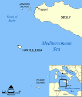
Pantelleria (Sicilian: Pantiddirìa), the ancient Cossyra (Arabic: قوصرة Qawṣirah, Maltese: Qawsra, now Pantellerija, Ancient Greek Kossyra, Κοσσύρα), is an Italian island and comune in the Strait of Sicily in the Mediterranean Sea, 100 kilometres (62 mi) southwest of Sicily and 60 km (37 miles) east of the Tunisian coast. Tunisia is visible on clear days. Administratively Pantelleria is a comune belonging to the Sicilian province of Trapani.
With an area of 83 square kilometres (32 sq mi), it is the largest volcanic satellite island of Sicily. The last eruption occurred in 1891, below sea level, and today phenomena related to volcanic activity can be observed, such as hot springs and fumaroles.
The highest peak, called Montagna Grande, reaches 836 metres (2,743 ft) above sea level.
History
.jpg)
Archaeological exploration has unearthed dwellings and artifacts 35,000 years old.
The original population of Pantelleria did not come from Sicily, but were of Iberian or Ibero-Ligurian stock. After a considerable interval, during which the island probably remained uninhabited, the Carthaginians took possession of it (no doubt owing to its importance as a station on the way to Sicily) probably around the beginning of the 7th century BC, occupying as their acropolis the twin hill of San Marco and Santa Teresa, 2 km (1.2 mi) south of the town of Pantelleria. The town has considerable remains of walls made of rectangular blocks of masonry, and also of a number of cisterns. Punic tombs have been discovered, and the votive terra-cottas of a small sanctuary of the Punic period were found near the north coast.
The Romans occupied the island as the Fasti Triumphales record in 255 BC, lost it again the next year, and recovered it in 217 BC. Under the Empire it served as a place of banishment for prominent persons and members of the imperial family. The town enjoyed municipal rights.
In 700 AD, Arabs conquered the island and named it بنت الرياح Bint al-Riyāḥ 'the daughter of the winds', which represents the strong winds that arise off the north coast of Africa. In 1123 Roger II of Sicily took the island, and in 1311 an Aragonese fleet, under the command of Lluís de Requesens, won a considerable victory here. Requesens's family became princes of Pantelleria until 1553, when the Turks captured the island. A naval battle took place near the island in July 1586 when an armed English merchant fleet of five ships managed to repel an attack by eleven Spanish and Maltese galleys.
A Siculo-Arabic dialect similar to Maltese was the vernacular of the island until the late 18th century, when the Romance Sicilian superseded it. The modern Sicilian language in Pantelleria contains many Arabic loanwords, and most of the island's place names are of Semitic origin.
During the Napoleonic Wars, the British considered the possibility of taking over Pantelleria (together with Lampedusa and Linosa) so as to be able to supply Malta, but a Royal Commission stated in an 1812 report that there would be considerable difficulties in this venture.[1]
Pantelleria's capture was regarded as crucial to Operation Husky, the Allied invasion of Sicily in 1943 as planes based on Pantelleria could readily reach Sicily. In Operation Corkscrew the Allies bombarded Pantelleria heavily from air and sea in the days before the invasion. The garrison surrendered as the landing troops approached. Pantelleria then became a vital base for Allied aircraft during the assault on Sicily.
Geology
The island of Pantelleria is located above a drowned continental rift in the Strait of Sicily and has been the focus of intensive volcano-tectonic activity. The 15 kilometre-long (9.3 mi) island is the emergent summit of a largely submarine edifice.[2] Two large Pleistocene calderas dominate the island, the older of the two formed about 114,000 years ago and the younger Cinque Denti caldera formed about 45,000 years ago.[3] The eruption that formed the Cinque Denti caldera produced the distinctive Green Tuff deposit that covers much of the island, and is found across the Mediterranean, as far away as the island of Lesbos in the Aegean.[4] Holocene eruptions have constructed pumice cones, lava domes, and short, blocky lava flows.[5]
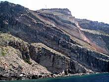
Post Green Tuff activity constructed the cone of Monte Gibele, part of which was subsequently uplifted to form Montagna Grande. Several vents are located on three sides of the uplifted Montagna Grande block on the southeast side of the island. A submarine eruption in 1891 from a vent off the northwest coast is the only confirmed historical activity.[6]
Currently the island is subsiding, and Montagna Grande is slowly sinking. This is thought to be caused by the magma beneath the volcano cooling and degassing.[7] There are numerous hot springs and fumaroles on the island due to an active hydrothermal system. Favara Grande, in the south east of the island, is one of the best examples. The island is releasing a small amount of CO2 through passive degassing.[8] Total carbon stock in the first 30 cm (11.8 in) of soil of Pantelleria is about 230,000 Mg.[9] The island is the type locality for peralkaline rhyolitic rocks, pantellerites.
Climate
| Climate data for Pantelleria 1971-2000 | |||||||||||||
|---|---|---|---|---|---|---|---|---|---|---|---|---|---|
| Month | Jan | Feb | Mar | Apr | May | Jun | Jul | Aug | Sep | Oct | Nov | Dec | Year |
| Record high °C (°F) | 21.6 (70.9) |
23.8 (74.8) |
27.8 (82) |
31.8 (89.2) |
36.6 (97.9) |
41.2 (106.2) |
41.4 (106.5) |
41.8 (107.2) |
40.5 (104.9) |
34.0 (93.2) |
25.8 (78.4) |
23.0 (73.4) |
41.8 (107.2) |
| Average high °C (°F) | 13.9 (57) |
14.0 (57.2) |
15.2 (59.4) |
17.7 (63.9) |
21.9 (71.4) |
25.7 (78.3) |
28.2 (82.8) |
29.0 (84.2) |
26.5 (79.7) |
22.6 (72.7) |
18.1 (64.6) |
15.1 (59.2) |
20.7 (69.2) |
| Daily mean °C (°F) | 11.9 (53.4) |
11.8 (53.2) |
12.8 (55) |
14.8 (58.6) |
18.6 (65.5) |
22.2 (72) |
24.7 (76.5) |
25.7 (78.3) |
23.4 (74.1) |
20.1 (68.2) |
15.9 (60.6) |
13.1 (55.6) |
17.9 (64.3) |
| Average low °C (°F) | 10.0 (50) |
9.6 (49.3) |
10.3 (50.5) |
11.9 (53.4) |
15.2 (59.4) |
18.7 (65.7) |
21.3 (70.3) |
22.4 (72.3) |
20.4 (68.7) |
17.5 (63.5) |
13.8 (56.8) |
11.1 (52) |
15.2 (59.3) |
| Record low °C (°F) | 1.0 (33.8) |
2.0 (35.6) |
1.8 (35.2) |
4.6 (40.3) |
9.4 (48.9) |
11.0 (51.8) |
15.2 (59.4) |
15.0 (59) |
13.4 (56.1) |
9.0 (48.2) |
5.0 (41) |
2.6 (36.7) |
1 (33.8) |
| Average rainfall mm (inches) | 76.3 (3.004) |
51.3 (2.02) |
37.5 (1.476) |
32.9 (1.295) |
15.1 (0.594) |
4.2 (0.165) |
1.9 (0.075) |
3.7 (0.146) |
49.9 (1.965) |
72.1 (2.839) |
89.0 (3.504) |
67.8 (2.669) |
501.7 (19.752) |
| Average rainy days (≥ 1.0 mm) | 8.7 | 7.9 | 6.0 | 5.4 | 2.5 | 0.9 | 0.2 | 0.6 | 3.4 | 6.6 | 8.3 | 8.2 | 58.7 |
| Mean monthly sunshine hours | 124.0 | 138.4 | 186.0 | 207.0 | 257.3 | 282.0 | 322.4 | 310.0 | 237.0 | 201.5 | 156.0 | 124.0 | 2,545.6 |
| Source: Atlante climatico frommeteoam.it | |||||||||||||
Main sights
Natural areas
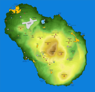
A large nature reserve is on the island, and a natural lake, called Specchio di Venere (Venus' mirror). It formed in an extinct volcanic crater, and is fed by rain and hot springs. The lake is 12 m (39 ft) deep and is popular for swimming, hot springs, and mud bathing. Other natural attractions are paths to the sea, a large network of trekking paths, hot springs, and a popular natural sauna fed by vapours filtering through rocks in a small cave.
Archaeological sites
A Middle Bronze Age village was on the west coast, 3 km (1.9 mi) southeast of the harbour, with a rampart of small blocks of lava, about 7.5 m (25 ft) high, 10 m (33 ft) wide at the base and 5 m (16 ft) at the top, upon the undefended eastern side. Remains of huts were found there, with pottery, tools of obsidian, and other artifacts. These objects are in the museum at Syracuse.
To the southeast, in the district known as the Cunelie, are many tombs, known as sesi. They are similar in character to the nuraghe of Sardinia, though of smaller size, and consist of round or elliptical towers with sepulchral chambers in them, built of rough blocks of lava. Fifty-seven of them can still be traced. The largest is an ellipse of about 18 by 20 m (59 by 66 ft), but most of the sesi have a diameter of only 6 to 7 m (20 to 23 ft). The identical character of the pottery found in the sesi with that found in the prehistoric village proves that the former are the tombs of the inhabitants of the latter.
Monuments and other buildings
The island has scattered typical one-level buildings called dammuso of unknown but probably remote origins. A dammuso is a dry stone building with thick walls that usually appear black due to the extensive use of volcanic rock. They have characteristic domes on top painted white to avoid overheating. The domes collect rainwater that is directed to a large tank (usually below the building) or to the nearby soil for use in the dry season.
Most of the other constructions were destroyed during the Second World War. One notable exception is the castle Barbacane, a renaissance building formed by an irregularly quadrangular plan with internal court joined to a squared base tower.
Wine
Pantelleria is noted for its sweet wines, Moscato di Pantelleria and Moscato Passito di Pantelleria, both made from the local Zibibbo grape.[11] In 2014, the traditional agricultural practice of cultivating the 'vite ad alberello' (head-trained bush vines) of the community of Pantelleria was inscribed on the Representative List of the Intangible Cultural Heritage of Humanity of Unesco (see ).
Transport
The island is served by Pantelleria Airport,[12] which is served by Alitalia, connecting Trapani and Palermo and other companies in summer, connecting the island with Italian cities such as Milan, Rome, Venice and others. Ferries reach the island from Trapani, and it is near the main east-west route through the Mediterranean.
See also
References

- ↑ Ganado, Albert (10 November 2013). "Lampedusa's strong and long-standing relationships with Malta". Times of Malta. Archived from the original on 21 September 2017.
- ↑ http://www.volcano.si.edu/world/volcano.cfm?vnum=0101-071
- ↑ Mahood, G.A.; W. Hildreth (1986). "Geology of the peralkaline volcano at Pantelleria, Strait of Sicily". Bulletin of Volcanology. 48 (2–3): 143–172. Bibcode:1986BVol...48..143M. doi:10.1007/BF01046548. Retrieved 2009-07-08.
- ↑ Margari, V.; D.M. Pyle; C. Bryant; P.L. Gibbard (1 June 2007). "Mediterranean tephra stratigraphy revisited: Results from a long terrestrial sequence on Lesvos Island, Greece". Journal of Volcanology and Geothermal Research. 163 (1–4): 34–54. Bibcode:2007JVGR..163...34M. doi:10.1016/j.jvolgeores.2007.02.002. ISSN 0377-0273. Retrieved 2009-09-20.
- ↑ http://www.volcano.si.edu/world/volcano.cfm?vnum=0101-071&volpage=synsub
- ↑ http://www.volcano.si.edu/world/volcano.cfm?vnum=0101-071&volpage=erupt
- ↑ Mattia, M.; A. Bonaccorso; F. Guglielmino (30 November 2007). "Ground deformations in the Island of Pantelleria (Italy): Insights into the dynamic of the current intereruptive period". Journal of Geophysical Research. 112: B11406. Bibcode:2007JGRB..11211406M. doi:10.1029/2006jb004781. Retrieved 2009-09-12.
- ↑ D'Alessandro, W. (2007). Final report of Research Unit V3_7/02. Palermo, Italy: Istituto Nazionale di Geofisica e Vulcanologia, Sezione Palermo. hdl:2122/4911.
- ↑ Saiano, F., Oddo, G., Scalenghe, R., La Mantia, T., Ajmone-Marsan, F. (2013). "DRIFTS sensor: soil carbon validation at large scale (Pantelleria, Italy)". Sensors. 13: 5603–5613. doi:10.3390/s130505603.
- ↑ http://clima.meteoam.it/AtlanteClim2/pdf/(470)Pantelleria.pdf
- ↑ "Moscato di Pantelleria (DOC)". Italian Trade Commission (ITC). 11 October 2011. Archived from the original on 24 April 2012.
- ↑ "Archived copy". Archived from the original on 3 September 2011. Retrieved 3 September 2011.
External links
 | ||