Treffurt
| Treffurt | ||
|---|---|---|
| ||
 Treffurt Location of Treffurt within Wartburgkreis district 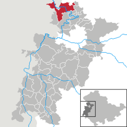 | ||
| Coordinates: 51°8′12″N 10°14′15″E / 51.13667°N 10.23750°ECoordinates: 51°8′12″N 10°14′15″E / 51.13667°N 10.23750°E | ||
| Country | Germany | |
| State | Thuringia | |
| District | Wartburgkreis | |
| Government | ||
| • Mayor | Michael Reinz (Ind.) | |
| Area | ||
| • Total | 54.76 km2 (21.14 sq mi) | |
| Elevation | 190 m (620 ft) | |
| Population (2017-12-31)[1] | ||
| • Total | 5,058 | |
| • Density | 92/km2 (240/sq mi) | |
| Time zone | CET/CEST (UTC+1/+2) | |
| Postal codes | 99830 | |
| Dialling codes | 036923 | |
| Vehicle registration | WAK | |
| Website | www.treffurt.de | |

Treffurt is a small town in the western region of the Wartburgkreis district which belongs to the federal state of Thuringia. The town lies near the Werra and is surrounded by the rivers beautiful valley, the Werratal. Treffurt is located next to the hessian border and was a former part of the Sperrzone. Today is Treffurt a popular tourist destination, especially due to its idyllic town centre with many restored half-timbered houses and its landmark - the Normannstein castle.
Notable residents

Egon Bahr in 1978
- Egon Bahr (1922-2015), German SPD politician
- Christian Mengis (flourished c.1745 – c.1766), composer and horn player
References
External links

Treffurt

This article is issued from
Wikipedia.
The text is licensed under Creative Commons - Attribution - Sharealike.
Additional terms may apply for the media files.