Stadtlengsfeld
| Stadtlengsfeld | ||
|---|---|---|
| ||
 Stadtlengsfeld Location of Stadtlengsfeld within Wartburgkreis district 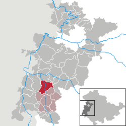 | ||
| Coordinates: 50°46′59″N 10°7′59″E / 50.78306°N 10.13306°ECoordinates: 50°46′59″N 10°7′59″E / 50.78306°N 10.13306°E | ||
| Country | Germany | |
| State | Thuringia | |
| District | Wartburgkreis | |
| Municipal assoc. | Dermbach | |
| Government | ||
| • Mayor | Ralf Adam | |
| Area | ||
| • Total | 27.61 km2 (10.66 sq mi) | |
| Elevation | 272 m (892 ft) | |
| Population (2017-12-31)[1] | ||
| • Total | 2,356 | |
| • Density | 85/km2 (220/sq mi) | |
| Time zone | CET/CEST (UTC+1/+2) | |
| Postal codes | 36457 | |
| Dialling codes | 036965 | |
| Vehicle registration | WAK | |
| Website | www.stadt-stadtlengsfeld.eu | |

Stadtlengsfeld is a town in the Wartburgkreis district of Thuringia, Germany. It is situated in the Rhön Mountains, 8 km southwest of Bad Salzungen.
History
Within the German Empire (1871-1918), Stadtlengsfeld was part of the Grand Duchy of Saxe-Weimar-Eisenach.
It was the site of the Menzengraben mining accident in 1953.
Sister cities
External links
![]()
References
- ↑ "Bevölkerung der Gemeinden, Gemeinschaftsfreie Gemeinde, erfüllende/beauftragende Gemeinden, Verwaltungsgemeinschaft/Mitgliedsgemeinden in Thüringen". Thüringer Landesamt für Statistik (in German). September 2018.
- ↑ "Testvértelepülések". Retrieved 30 April 2014.

This article is issued from
Wikipedia.
The text is licensed under Creative Commons - Attribution - Sharealike.
Additional terms may apply for the media files.