Kaltennordheim
| Kaltennordheim | ||
|---|---|---|
| ||
 Kaltennordheim Location of Kaltennordheim within Wartburgkreis district 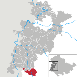 | ||
| Coordinates: 50°38′N 10°10′E / 50.633°N 10.167°ECoordinates: 50°38′N 10°10′E / 50.633°N 10.167°E | ||
| Country | Germany | |
| State | Thuringia | |
| District | Wartburgkreis | |
| Government | ||
| • Mayor | Frank Kampf (Ind.) | |
| Area | ||
| • Total | 40.41 km2 (15.60 sq mi) | |
| Elevation | 440 m (1,440 ft) | |
| Population (2017-12-31)[1] | ||
| • Total | 3,326 | |
| • Density | 82/km2 (210/sq mi) | |
| Time zone | CET/CEST (UTC+1/+2) | |
| Postal codes | 36452 | |
| Dialling codes | 036966 | |
| Vehicle registration | WAK | |

Kaltennordheim is a town in the Wartburgkreis district, in Thuringia, Germany. It is situated in the Rhön Mountains, 22 km southwest of Bad Salzungen, and 35 km east of Fulda.
History
Within the German Empire (1871-1918), Kaltennordheim was part of the Grand Duchy of Saxe-Weimar-Eisenach.
References
This article is issued from
Wikipedia.
The text is licensed under Creative Commons - Attribution - Sharealike.
Additional terms may apply for the media files.