Larue, Arkansas
| Larue, Arkansas | |
|---|---|
| Unincorporated community | |
 Larue, Arkansas  Larue, Arkansas | |
| Coordinates: 36°20′30″N 93°56′46″W / 36.34167°N 93.94611°WCoordinates: 36°20′30″N 93°56′46″W / 36.34167°N 93.94611°W | |
| Country | United States |
| State | Arkansas |
| County | Benton |
| Elevation | 1,161 ft (354 m) |
| Time zone | UTC-6 (Central (CST)) |
| • Summer (DST) | UTC-5 (CDT) |
| Area code(s) | 479 |
| GNIS feature ID | 77452[1] |
Larue is an unincorporated community in Benton County, Arkansas, United States. Larue was established in the late 19th century as a community for orchard workers. In the 1920s, the community transitioned to an economy based on animal husbandry and grain farming as orchard production declined in the area.[2]
The Coal Gap School, which is listed on the National Register of Historic Places, was built in 1928 to serve the Larue area.[3] The creation of Beaver Lake in the 1960s separated the school from Larue.[2]
References
- ↑ "Larue". Geographic Names Information System. United States Geological Survey.
- 1 2 "Coal Gap School, Larue, Benton County". Arkansas Historic Preservation Program. Archived from the original on April 7, 2013. Retrieved February 15, 2013.
- ↑ National Park Service (2010-07-09). "National Register Information System". National Register of Historic Places. National Park Service.
Municipalities and communities of Benton County, Arkansas, United States | ||
|---|---|---|
| Cities | 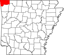 | |
| Towns | ||
| Townships | ||
| CDPs | ||
| Other communities |
| |
| Ghost towns | ||
| Footnotes | ‡This populated place also has portions in an adjacent county or counties | |
This article is issued from
Wikipedia.
The text is licensed under Creative Commons - Attribution - Sharealike.
Additional terms may apply for the media files.