Tonovay, Kansas
| Tonovay, Kansas | |
|---|---|
| Unincorporated community | |
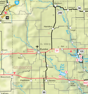 KDOT map of Greenwood County (legend) | |
 Tonovay  Tonovay | |
| Coordinates: 37°51′8″N 96°10′41″W / 37.85222°N 96.17806°WCoordinates: 37°51′8″N 96°10′41″W / 37.85222°N 96.17806°W[1] | |
| Country | United States |
| State | Kansas |
| County | Greenwood |
| Elevation[1] | 1,060 ft (320 m) |
| Time zone | UTC-6 (CST) |
| • Summer (DST) | UTC-5 (CDT) |
| Area code | 620 |
| FIPS code | 20-70850 [1] |
| GNIS ID | 474649 [1] |
Tonovay (also Ton of Hay) is an unincorporated community in Greenwood County, Kansas, United States.[1][2]
References
Municipalities and communities of Greenwood County, Kansas, United States | ||
|---|---|---|
| Cities | 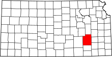 | |
| Unincorporated communities | ||
| Ghost towns | ||
| Townships | ||
This article is issued from
Wikipedia.
The text is licensed under Creative Commons - Attribution - Sharealike.
Additional terms may apply for the media files.