Salt Springs Township, Greenwood County, Kansas
| Salt Springs Township | |
|---|---|
| Township | |
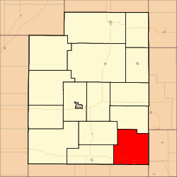 Location in Greenwood County | |
| Coordinates: 37°40′15″N 096°02′31″W / 37.67083°N 96.04194°WCoordinates: 37°40′15″N 096°02′31″W / 37.67083°N 96.04194°W | |
| Country | United States |
| State | Kansas |
| County | Greenwood |
| Area | |
| • Total | 74.22 sq mi (192.22 km2) |
| • Land | 70.39 sq mi (182.3 km2) |
| • Water | 3.83 sq mi (9.92 km2) 5.16% |
| Elevation | 1,053 ft (321 m) |
| Population (2000) | |
| • Total | 463 |
| • Density | 6.6/sq mi (2.5/km2) |
| GNIS feature ID | 0474887 |
Salt Springs Township is a township in Greenwood County, Kansas, USA. As of the 2000 census, its population was 463.
Geography
Salt Springs Township covers an area of 74.22 square miles (192.2 km2) and contains one incorporated settlement, Fall River. According to the USGS, it contains four cemeteries: Browns Chapel, Charleston, Pike (historical) and Township.
The streams of Badger Creek, Casner Creek, Crain Creek, Little Salt Creek, Salt Creek and Shawnee Creek run through this township.
Transportation
Salt Springs Township contains one airport or landing strip, Heir Airport.
References
External links
Municipalities and communities of Greenwood County, Kansas, United States | ||
|---|---|---|
| Cities | 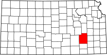 | |
| Unincorporated communities | ||
| Ghost towns | ||
| Townships | ||
This article is issued from
Wikipedia.
The text is licensed under Creative Commons - Attribution - Sharealike.
Additional terms may apply for the media files.