South Salem Township, Greenwood County, Kansas
| South Salem Township | |
|---|---|
| Township | |
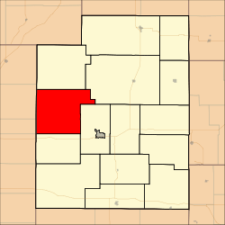 Location in Greenwood County | |
| Coordinates: 37°53′30″N 096°26′06″W / 37.89167°N 96.43500°WCoordinates: 37°53′30″N 096°26′06″W / 37.89167°N 96.43500°W | |
| Country | United States |
| State | Kansas |
| County | Greenwood |
| Area | |
| • Total | 87.61 sq mi (226.9 km2) |
| • Land | 86.61 sq mi (224.32 km2) |
| • Water | 0.99 sq mi (2.57 km2) 1.13% |
| Elevation | 1,273 ft (388 m) |
| Population (2000) | |
| • Total | 127 |
| • Density | 1.5/sq mi (0.6/km2) |
| GNIS feature ID | 0474420 |
South Salem Township is a township in Greenwood County, Kansas, USA. As of the 2000 census, its population was 127.
Geography
South Salem Township covers an area of 87.61 square miles (226.9 km2) and contains no incorporated settlements. According to the USGS, it contains two cemeteries: Highland and Ladd.
The streams of Cat Creek, Coon Creek, Hog Creek, Ivanpah Creek, Oleson Creek and Otis Creek run through this township.
References
External links
Municipalities and communities of Greenwood County, Kansas, United States | ||
|---|---|---|
| Cities | 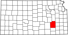 | |
| Unincorporated communities | ||
| Ghost towns | ||
| Townships | ||
This article is issued from
Wikipedia.
The text is licensed under Creative Commons - Attribution - Sharealike.
Additional terms may apply for the media files.