Tištín
| Tištín | |||
|---|---|---|---|
| Městys | |||
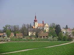 Saints Peter and Paul Church | |||
| |||
 Tištín | |||
| Coordinates: 49°18′17″N 17°10′10″E / 49.30472°N 17.16944°ECoordinates: 49°18′17″N 17°10′10″E / 49.30472°N 17.16944°E | |||
| Country |
| ||
| Region | Olomouc | ||
| District | Prostějov | ||
| Area | |||
| • Total | 8.25 km2 (3.19 sq mi) | ||
| Elevation | 220 m (720 ft) | ||
| Population (2006) | |||
| • Total | 529 | ||
| • Density | 64/km2 (170/sq mi) | ||
| Postal code | 798 29 | ||
| Website | http://www.tistin.cz | ||


Tištín is a market town (městys) in Prostějov District in the Olomouc Region of the Czech Republic.
The town covers an area of 8.25 square kilometres (3.19 sq mi), and has a population of 529 (as at 28 August 2006).
Tištín lies approximately 20 kilometres (12 mi) south of Prostějov, 33 km (21 mi) south of Olomouc, and 217 km (135 mi) south-east of Prague.
References
| Wikimedia Commons has media related to Tištín. |
This article is issued from
Wikipedia.
The text is licensed under Creative Commons - Attribution - Sharealike.
Additional terms may apply for the media files.