Brodek u Konice
| Brodek u Konice | |||
|---|---|---|---|
| Municipality | |||
 | |||
| |||
 Brodek u Konice | |||
| Coordinates: 49°32′56″N 16°49′52″E / 49.54889°N 16.83111°ECoordinates: 49°32′56″N 16°49′52″E / 49.54889°N 16.83111°E | |||
| Country |
| ||
| Region | Olomouc | ||
| District | Prostějov | ||
| Area | |||
| • Total | 14.15 km2 (5.46 sq mi) | ||
| Elevation | 595 m (1,952 ft) | ||
| Population (2006) | |||
| • Total | 943 | ||
| • Density | 67/km2 (170/sq mi) | ||
| Postal code | 798 46 | ||
| Website | http://www.brodek-u-konice.cz | ||
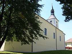
Brodek u Konice is a village and municipality (obec) in Prostějov District in the Olomouc Region of the Czech Republic.
The municipality covers an area of 14.15 square kilometres (5.46 sq mi), and has a population of 943 (as at 28 August 2006).
Brodek u Konice lies approximately 22 kilometres (14 mi) north-west of Prostějov, 31 km (19 mi) west of Olomouc, and 184 km (114 mi) east of Prague.
References
| Wikimedia Commons has media related to Brodek u Konice. |
This article is issued from
Wikipedia.
The text is licensed under Creative Commons - Attribution - Sharealike.
Additional terms may apply for the media files.