Klenovice na Hané
| Klenovice na Hané | |||
|---|---|---|---|
| Municipality | |||
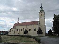 Church of Saint Bartholomew | |||
| |||
 Klenovice na Hané | |||
| Coordinates: 49°24′15″N 17°12′56″E / 49.40417°N 17.21556°ECoordinates: 49°24′15″N 17°12′56″E / 49.40417°N 17.21556°E | |||
| Country |
| ||
| Region | Olomouc | ||
| District | Prostějov | ||
| Area | |||
| • Total | 8.01 km2 (3.09 sq mi) | ||
| Elevation | 227 m (745 ft) | ||
| Population (2006) | |||
| • Total | 843 | ||
| • Density | 110/km2 (270/sq mi) | ||
| Postal code | 798 23 | ||
| Website | http://www.klenovicenahane.cz | ||


Klenovice na Hané is a village and municipality (obec) in Prostějov District in the Olomouc Region of the Czech Republic.
The municipality covers an area of 8.01 square kilometres (3.09 sq mi), and has a population of 843 (as at 28 August 2006).
Klenovice na Hané lies approximately 11 kilometres (7 mi) south-east of Prostějov, 22 km (14 mi) south of Olomouc, and 215 km (134 mi) east of Prague.
References
| Wikimedia Commons has media related to Klenovice na Hané. |
This article is issued from
Wikipedia.
The text is licensed under Creative Commons - Attribution - Sharealike.
Additional terms may apply for the media files.