Territorial evolution of New Mexico
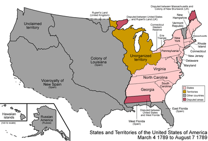
An enlargeable map of the United States after the Treaty of Paris in 1789
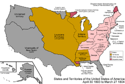
An enlargeable map of the United States after the Louisiana Purchase in 1803

An enlargeable map of the United States after the Adams-Onís Treaty took effect in 1821
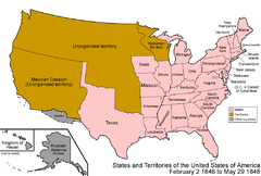
An enlargeable map of the United States after the Treaty of Guadalupe Hidalgo in 1848

Proposed boundaries for State of New Mexico, 1850
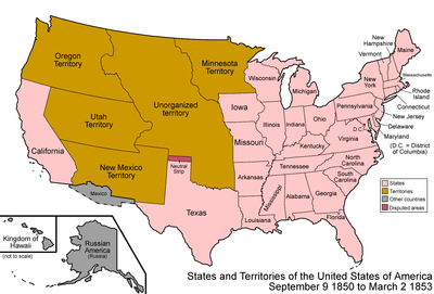
An enlargeable map of the United States after the Compromise of 1850

An enlargeable map of the United States after the Gadsden Purchase in 1853
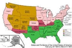
An enlargeable map of the United States after the Arizona Organic Act in 1863
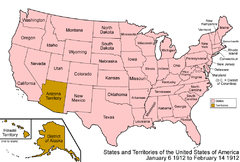
An enlargeable map of the United States after New Mexico Statehood in 1912
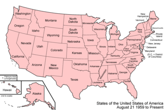
An enlargeable map of the United States as it has been since 1959
The following timeline traces the territorial evolution of the U.S. State of New Mexico.
Timeline
- Historical territorial claims of Spain in the present State of New Mexico:
- Nueva Vizcaya, 1562–1821
- Santa Fé de Nuevo Méjico, 1598–1821
- Treaty of Córdoba of 1821
- Historical territorial claims of France in the present State of New Mexico:
- Louisiane, 1682–1764
- Historical territorial claims of Spain in the present State of New Mexico:
- Luisiana, 1764–1803
- Third Treaty of San Ildefonso of 1800
- Luisiana, 1764–1803
- Historical territorial claims of France in the present State of New Mexico:
- Louisiane, 1803
- Vente de la Louisiane of 1803
- Louisiane, 1803
- Historical territorial claims of Mexico in the present State of New Mexico:
- Santa Fé de Nuevo México, 1821–1848
- Treaty of Guadalupe Hidalgo of 1848
- Santa Fé de Nuevo México, 1821–1848
- Historical territorial claims of the Republic of Texas in the present State of New Mexico:
- Disputed territory east of the Rio Grande, 1836–1845
- Texas Annexation of 1845
- Disputed territory east of the Rio Grande, 1836–1845
- Historical political divisions of the United States in the present State of New Mexico:
- Unorganized territory created by the Louisiana Purchase, 1803–1804
- District of Louisiana, 1804–1805
- Territory of Louisiana, 1805–1812
- Territory of Missouri, 1812–1821
- Territory of Arkansaw, 1819–1836
- Adams–Onís Treaty of 1819
- Disputed territory created by the Texas Annexation, 1845–1850
- MexicanvAmerican War, 1846–1848
- U.S. Military Province of New Mexico, 1846
- U.S. Provisional Government of New Mexico 1846–1850
- Unorganized territory created by the Treaty of Guadalupe Hidalgo, 1848–1850
- State of Deseret (extralegal), 1849–1850
- Proposed state of New Mexico, 1850
- Territory of New Mexico, 1850–1912[1]
- Gadsden Purchase of 1853
- American Civil War, 1861–1865
- Arizona Territory (CSA), 1861–1865
- State of New Mexico since 1912[2]
See also


References
- ↑ Thirty-First United States Congress (September 9, 1850). "An Act proposing to the State of Texas the Establishment of her Northern and Western Boundaries, the Relinquishment by the said State of all Territory claimed by her exterior to said Boundaries, and of all her Claims upon the United States, and to establish a territorial Government for New Mexico" (cgi-bin). Retrieved June 4, 2009.
- ↑ William Howard Taft (January 6, 1912). "By the President of the United States of America, A Proclamation Admitting the State of New Mexico to the Union". Retrieved June 4, 2009.
External links
Santa Fe (capital) | ||
| Topics |
| |
| Society | ||
| Regions |
| |
| Cities | ||
| Counties | ||

This article is issued from
Wikipedia.
The text is licensed under Creative Commons - Attribution - Sharealike.
Additional terms may apply for the media files.